Weston, North Yorkshire
Weston is a village and civil parish in the Harrogate district of North Yorkshire, England. It is 1.2 miles (2 km) north west of Otley and near to the River Wharfe which forms the boundary between North and West Yorkshire in the area.[2] The name is from Old English and means western enclosure, farmstead or village.[3]
| Weston | |
|---|---|
 Weston Location within North Yorkshire | |
| Population | 209 (2011)[1] |
| OS grid reference | SE178470 |
| District | |
| Shire county | |
| Region | |
| Country | England |
| Sovereign state | United Kingdom |
| Post town | OTLEY |
| Postcode district | LS21 |
| Police | North Yorkshire |
| Fire | North Yorkshire |
| Ambulance | Yorkshire |
The village of Weston should not be confused with the nearby Weston Estate, a housing estate between Newall and Weston within Otley and West Yorkshire.[4]
The Weston Estate, still owned by the Vavasour family, encompasses the northern part of the village including commercial premises and farmland whilst to the south Weston Hall is part of the Askwith Estate located south east of the village and adjoining the north bank of the River.
Weston was historically part of the West Riding of Yorkshire until 1974.[5]
History
The church in the village is recorded in the Domesday book, although there is evidence of Christian worship before this time (most notably that of a 9th-century cross that was found in the graveyard).[6] The church is mostly Norman with some 17th and 19th century additions and was Grade I listed in 1966.[7] The church bells were stolen in March 1990 and when they were eventually retrieved, expert analysis revealed them to be amongst the oldest bells in Britain, with one dating from at least the year 1200. Heritage Lottery Funding was successfully applied for and after careful restoration, the bells were re-hung in the church in October 2016.[8]
Weston village is north west of Otley and north of east of Burley-in-Wharfedale, being separated from both by the River Wharfe. Access to the village is on unclassfield roads from Otley and the north, with no direct access across the river to Burley-in-Wharfedale.[9] Drivers have to either go the short distance to Otley and turn west as the next bridge upstream is at Ilkley some 5.6 miles (9 km) further upstream.[2] The Six Dales Trail edges along the woods at the north western end of the village. The trail is 38 miles (61 km) long and runs between Otley and Middleham in North Yorkshire.[10]
Farming has been the main occupation of the inhabitants of Weston for many centuries and the appealing rural nature of the area has been noted as part of the Nidderdale Area of Outstanding Natural Beauty, which was signified in 1994.[11]
Land at the eastern end of the village (known as Gallows Hill) which adjoins the Weston housing estate, was used during the Second World War and beyond until 1948 to house German Prisoners of War. Most of the site was destroyed to make way for the new housing estate.[12]
Lords of the manor
Before the Domesday book was collated, the area was originally part of Otley Manor, but was then separated off north of the river. After Domesday, the estate was granted to Berenger de Tosny.[13] According to the national archives, the archived documents for Weston "relate chiefly to the Yorkshire estates of the Vavasours of Weston from whom they have descended to the present owner. The property was built-up by Sir Brian de Lisle (Latinized as de Insula), who died in 1234, and by his nephew Sir Robert de Stopham (died before 1275). The Stophams seem to have originated in Sussex and Dorset and the Yorkshire branch to have been established by the Lisle inheritance."[14] "Sir Robert de Stopham's daughter Maud married John le Vavasour of Denton, to whose descendents the property passed on the failure of the Stopham line in the middle of the fourteenth century. It then comprised the manors of Weston and Newton (in the parish of Nidd) and other lands at Burley-in-Wharfedale and Baildon. The last of the Baildon property appears to have been sold c.1700 and that at Newton in 1795."
In 1833, William Vavasour died and the estate passed onto his nephew (William Elmsall Carter) who was an attorney from Lincoln. Carter died the following year in 1834 and his daughters (Emma Carter and Susan Carter) inherited the estate. Emma Carter married Christopher Holdsworth Dawson, whose grandfather was one of the founders of the Low Moor Ironworks and Susan Married William Millthorpe Spence M.D. Through these marriages, the estate was split and passed down through the Vavasour Dawson line to Herbrand Vavasour Dawson and the Carter Spence line to Malger Powis Vavasour as joint Lords of the Manor of Weston.[15]
Weston Hall and Weston Manor
Weston Hall is made up of many grand rooms, one of which is called the dragon room due to the plaster sculpting in the ceiling. There is a second building, mainly used by the men of the estate for playing snooker and telling tales. There is also a small church on the property, built in the 1200s and holding many old records.[16]
Weston Manor is a substantial Victorian country house built of stone with a Westmoreland slate roof. Dating from 1899 the present property replaced Deanfield House and was built to the design of Kilnwick Hall in the East Riding of Yorkshire with the addition of the Tower on the front elevation, which emaulated one of the principal features of Deanfield house.
Dob Park Lodge
Dob Park Lodge is a Scheduled Ancient Monument which is located in an isolated position within the Nidderdale AONB overlooking the Linley Wood reservoir. It dates from the early 17th century and was commissioned by Sir Mauger Vavasour as part of a deer park which formed part of the Weston Estate. It may have fallen into disuse fairly quickly, however, and was close to its current ruinous state when it was painted by J M W Turner (“Washburn under Folly Hall”) in around 1815.[18]
Gallery
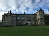 This is the main Weston Hall estate as viewed from the lawn in front.
 More or less a man cave, this is where the men of Weston Hall gathered to play snooker.
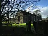 Weston Church, dating to the early 1200s, kept local records for hundreds of years.
 The vicars of Weston Hall dating back to 1240.
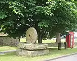 Village green.
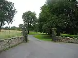 Entrance to Weston Manor , former residence of the Vavasour Family
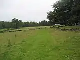 Woodland owned by the Weston Estate, including an award winning Clay Pidgeon shooting ground.
 Dob Park Lodge (Remains) - 17th century hunting lodge built by the Vavasour family.
References
- "Parish population 2011". Neighbourhood Statistics. Office for National Statistics. Retrieved 6 August 2015.
- "104" (Map). Leeds & Bradford. 1:50,000. Landranger. Ordnance Survey. 2016. ISBN 978-0-319-26202-3.
- Ekwall, Eilert (1960). The concise Oxford dictionary of English place-names (4 ed.). Cambridge: Cambridge University Press. p. 508. OCLC 400936.
- Redhead, Jonathan (4 July 2011). "Drugs seized in raids on Otley estate". Bradford Telegraph and Argus. Retrieved 10 January 2017.
- "History of Weston, in Harrogate and West Riding | Map and description". www.visionofbritain.org.uk. Retrieved 24 November 2020.
- "Weston: All Saints, Weston". A Church Near You. Retrieved 10 January 2017.
- Historic England. "Helmsley Castle: Church of All Saints (1150440)". National Heritage List for England. Retrieved 10 January 2017.
- Jack, Jim (13 October 2016). "New lease of life for Wharfedale church's ancient bells". Wharfedale Observer. Retrieved 10 January 2017.
- "Weston Conservation Area Character Appraisal" (PDF). nidderdaleaonb.org.uk. Harrogate Borough Council. 16 November 2011. p. 5. Retrieved 10 January 2017.
- Sparshatt, John. "Six Dales Trail". www.sixdalestrail.org.uk. Retrieved 10 January 2017.
- "Weston Conservation Area Character Appraisal" (PDF). nidderdaleaonb.org.uk. Harrogate Borough Council. 16 November 2011. p. 4. Retrieved 10 January 2017.
- Historic England. "Weston Lane POW camp (1369126)". PastScape. Retrieved 10 January 2017.
- "Weston Conservation Area Character Appraisal" (PDF). nidderdaleaonb.org.uk. Harrogate Borough Council. 16 November 2011. p. 3. Retrieved 10 January 2017.
- "The Discovery Service". discovery.nationalarchives.gov.uk. The National Archives. Retrieved 10 January 2017.
- Baildon, William Paley. "Ebook Baildon and the Baildons; a history of a Yorkshire manor and family (Volume 1)". www.ebooksread.com. Retrieved 24 July 2019.
- Historic England. "Weston Hall and Banqueting House (49798)". PastScape. Retrieved 10 January 2017.
- Historic England. "A 17th century park lodge known as Dobpark Lodge in Dob Park, near Otley, Weston (1015630)". National Heritage List for England. Retrieved 29 July 2019.
- "Dob Park Lodge, Dob Park Lane, Weston - Harrogate | Historic England". historicengland.org.uk. Retrieved 28 July 2019.
External links
| Wikimedia Commons has media related to Weston, North Yorkshire. |