Whitehope Law
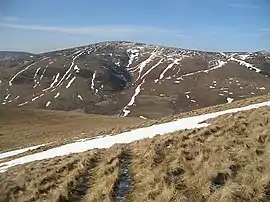
Whitehope Law is a hill in the Moorfoot Hills range, part of the Southern Uplands of Scotland. A relatively isolated hill, it is frequently climbed on its own from the B709 road to its south and east.[4] A farm to the south lends its name to the hill.[5]
| Whitehope Law | |
|---|---|
 | |
| Highest point | |
| Elevation | 623 m (2,044 ft) [1] |
| Prominence | 66 m (217 ft) [2] |
| Listing | Tu,Sim, D,GT,DN[3] |
| Geography | |
| Location | Scottish Borders, Scotland |
| Parent range | Moorfoot Hills, Southern Uplands |
| OS grid | NT 33032 44574 |
| Topo map | OS Landranger 73 |
References
- http://www.hill-bagging.co.uk/mountaindetails.php?qu=S&rf=1804
- http://www.hill-bagging.co.uk/mountaindetails.php?qu=S&rf=1804
- http://www.hills-database.co.uk/database_notes.html#classification
- http://www.hill-bagging.co.uk/mountaindetails.php?qu=S&rf=1804
- https://www.scottish-places.info/parishes/pardetails877.html
This article is issued from Wikipedia. The text is licensed under Creative Commons - Attribution - Sharealike. Additional terms may apply for the media files.