Wigtown Bay
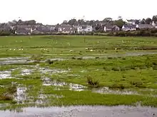
Wigtown Bay is a large inlet of the Irish Sea on the coast of Galloway in southwest Scotland. Its coastline falls entirely within the modern administrative area of Dumfries and Galloway and shared between the historical counties of Wigtownshire and Kirkcudbrightshire.

The bay is broadly triangular in form, widening to the southeast and with the estuary of the River Cree entering from the northwest at its head. The inner parts of the bay are characterized by large expanses of salt marsh and mudflats.[1] The River Bladnoch flows into the estuarial section of the Cree near Wigtown. The Water of Fleet is a third significant river which enters Wigtown Bay via Fleet Bay on its eastern shore. At the mouth of Fleet Bay are the Islands of Fleet include Ardwall Island, Barlocco Isle and Murray’s Isles.[2] The western shore of the bay is formed by The Machars peninsula. This coast is itself indented by Rigg (or Cruggleton) Bay and by Garlieston Bay on which the village of Garlieston sits. The small town of Wigtown also stands on the western shore of the bay whilst the village of Creetown lies at the head of the bay.
Wigtown Bay forms the largest local nature reserve in Britain.[1] It has also been designated as a site of special scientific interest.
A proposal to construct an offshore windfarm in Wigtown Bay was turned down by the Scottish government in early 2011. The potential effect on tourism was cited as a major reason in the decision.[3]
As of 2014, Wigtown Bay is currently under threat from another industrial turbine project, this time by Ecotricity. An application for a met mast was overturned by Dumfries and Galloway Council in August (At the Planning Applications Committee meeting on 27 August 2014 a petition with over 250 signatures of people from The Machars objecting to the met mast was also tabled), but the renewable energy company have appealed directly to the Scottish Government. Should the met mast be erected, it will be a precursor to a 7 x 110m tip height wind turbine site overlooking the bay. This development is called California.
Almost 180 submissions from members of the public were made to the Scottish Government (DPEA) about the proposed met mast. Not one, was in favour.
On 4 November 2014, Ecotricity, submitted a Proposal of Application Notice for 7 x 110m turbines (California) to Dumfries and Galloway Council.
A public meeting was held at the Wigtown County Buildings on Tuesday 16 December 2014. Ecotricity declined to attend, although they decided to hold an invitee only 'Community Liaison Group' at the same venue on 18 December - a date which Save Wigtown Bay offered them as a choice of three dates to attend the public meeting initially.
On 20 February 2015, Ecotricity submitted a full planning application to Dumfries and Galloway Council, this, despite not receiving a decision on its met mast appeal from the Scottish government.
On 9 April 2015, Ecotricity's appeal was successful.
On 10 April 2015, the deadline to object to California (15/P/2/0053) passed. Nearly 1300 individual objections were logged. 6 community councils have also opposed the plans.
Historic Scotland officially object to California on 30 April 2015.
A Dumfries and Galloway Council planning determination deadline for 'California' has now been set at 31 October. As at 28 November 2015, a decision is yet to be made.
On 29 January 2016 Ecotricity lodged a direct planning Appeal with the Scottish Government DPEA for 'California.' (PPA-170-2107). They have done this before the elected representatives on the Dumfries and Galloway Council Planning Applications Committee, have made its decision on the proposed turbine site.
A DPEA decision on the 'California' industrial turbine site will be made by 16 June 2016.
On 19 July 2016 Ecotricity's appeal was dismissed.
Naval connections
The design of the floating Mulberry Harbour used in the successful invasion of Normandy by allied forces during the Second World War was tested in the bay where conditions were felt to be suitably similar to those of the Normandy coast. There was also a World War II Bay class frigate named Wigtown Bay [4]
References
- "DG Community - Business & Commerce Blog For The Digital World". Dgcommunity.net. Retrieved 6 June 2016.
- Ordnance Survey 1:25,000 scale Explorer map sheets 311 and 312
- "Wigtown Bay wind farm bid knocked back by government". Bbc.co.uk. Retrieved 6 June 2016.
- "HMS Wigtown Bay, frigate". Naval-history.net. Retrieved 6 June 2016.