Wisconsin Highway 55
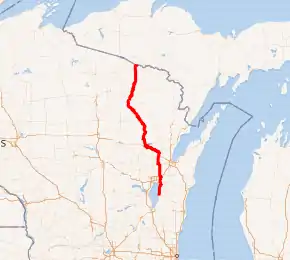
State Trunk Highway 55 (often called Highway 55, STH-55, or WIS 55) is a state highway in Wisconsin, United States. It travels south-to-north in the northeastern part of Wisconsin from an intersection with U.S. Route 151 (US 151) approximately 1.5 miles (2.4 km) north of Brothertown, near the eastern shore of Lake Winnebago in Calumet County, to the Michigan state line at the Brule River approximately one mile (1.6 km) northeast of Nelma in Forest County, where it connects to M-73.
| ||||
|---|---|---|---|---|

WIS 55 highlighted in red | ||||
| Route information | ||||
| Maintained by WisDOT | ||||
| Length | 175.55 mi[1] (282.52 km) | |||
| Major junctions | ||||
| South end | ||||
| North end | ||||
| Location | ||||
| Counties | Calumet, Outagamie, Shawano, Menominee, Langlade, Forest | |||
| Highway system | ||||
| ||||
Route description
Along its route, STH-55 serves Kaukauna, Shawano, the Menominee Indian Reservation, Crandon, and the Nicolet side of the Chequamegon-Nicolet National Forest.
History
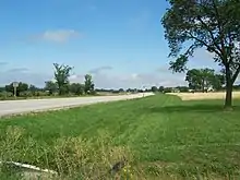
A new roundabout was opened at the intersection of WIS 55 and US 10 between Sherwood and Kaukauna in the autumn of 2009. Another roundabout recently opened at the busy intersection of WIS 55 and WIS 114 approximately one mile (1.6 km) west of Sherwood, Wisconsin.
Over the summer of 2018, a 1 mile (1.6 km) section of the Wisconsin Highway 55 in Kaukauna will be reconstructed and 4 new roundabouts will be added.[2]

Major intersections
| County | Location | mi | km | Destinations | Notes | |
|---|---|---|---|---|---|---|
| Calumet | Town of Chilton | 0.0 | 0.0 | Southern terminus | ||
| Sherwood | 11.9 | 19.2 | Southern end of WIS 114 concurrency | |||
| 14.4 | 23.2 | Northern end of WIS 114 concurrency | ||||
| Town of Harrison | 15.9 | 25.6 | ||||
| Outagamie | Kaukauna | 19.2 | 30.9 | |||
| 21.2 | 34.1 | Western end of WIS 96 concurrency | ||||
| 21.6 | 34.8 | Eastern end of WIS 96 concurrency | ||||
| 22.6 | 36.4 | |||||
| Oneida | 36.8 | 59.2 | Eastern end of WIS 54 concurrency | |||
| Seymour | 38.8 | 62.4 | Western end of WIS 54 concurrency | |||
| Shawano | Rose Lawn | 45.8 | 73.7 | |||
| Angelica | 51.1 | 82.2 | Eastern end of WIS 29 concurrency | |||
| Bonduel | 59.2 | 95.3 | Southern end of WIS 47 concurrency | |||
| Shawano | 65.9 | 106.1 | Western end of WIS 29 concurrency | |||
| 67.7 | 109.0 | Eastern end of WIS 22 concurrency | ||||
| 69.7 | 112.2 | Western end of WIS 22 concurrency | ||||
| Menominee | Keshena | 78.1 | 125.7 | Northern end of WIS 47 concurrency | ||
| Langlade | Langlade | 103.3 | 166.2 | |||
| Lily | 114.8 | 184.8 | Eastern end of WIS 52 concurrency | |||
| 114.9 | 184.9 | Western end of WIS 52 concurrency | ||||
| Forest | Crandon | 139.0 | 223.7 | Southern end of US 8/WIS 32 concurrency | ||
| 139.5 | 224.5 | Northern end of US 8 concurrency | ||||
| Argonne | 146.1 | 235.1 | Northern end of WIS 32 concurrency | |||
| Town of Alvin | 169.4 | 272.6 | ||||
| 175.55 | 282.52 | Continuation into Michigan | ||||
1.000 mi = 1.609 km; 1.000 km = 0.621 mi
| ||||||
See also
 U.S. Roads portal
References
- Bessert, Chris. "Wisconsin Highways: Highways 50-59 (Highway 55)". Wisconsin Highways. Retrieved 2007-03-20.
- "Project Overview – WIS 55 Kaukauna". projects.511wi.gov. Retrieved 2018-03-07.
