Wyoming Highway 375
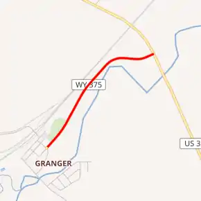
Wyoming Highway 375 (WYO 375) is a short 0.95-mile-long (1.53 km) spur route in Sweetwater County that serves the town of Granger.
| ||||
|---|---|---|---|---|
| Granger Road | ||||

WYO 375 highlighted in red | ||||
| Route information | ||||
| Maintained by WYDOT | ||||
| Length | 0.95 mi[1] (1.53 km) | |||
| Major junctions | ||||
| West end | 3rd Street in Granger | |||
| East end | ||||
| Location | ||||
| Counties | Sweetwater | |||
| Highway system | ||||
State highways in Wyoming
| ||||
Route description
Wyoming Highway 375 begins in the small town of Granger at 3rd Street and Pine Street. WYO 375 travels 0.95 miles, paralleling Blacks Fork, till it reaches U.S. Route 30 where it ends on the northeast edge of Granger. Granger and WYO 375 are located northwest of the Interstate 80/U.S. Route 30 and Wyoming Highway 374 junction.[2][3]
Major intersections
The entire route is in Granger, Sweetwater County.
| mi | km | Destinations | Notes | ||
|---|---|---|---|---|---|
| 0.00 | 0.00 | 3rd Street | Western terminus of WYO 375 | ||
| 0.95 | 1.53 | Eastern terminus of WYO 375 | |||
| 1.000 mi = 1.609 km; 1.000 km = 0.621 mi | |||||
References
- Wyoming Department of Transportation Reference Marker Book - November 2004 (PDF) (Map). WYDOT. Archived from the original (PDF) on July 17, 2011. Retrieved 2011-10-19.
- Google (28 December 2016). "Overview Map of Wyoming Highway 375" (Map). Google Maps. Google. Retrieved 28 December 2016.
- Wyoming @ AARoads.com - Wyoming Routes 300-399
External links
This article is issued from Wikipedia. The text is licensed under Creative Commons - Attribution - Sharealike. Additional terms may apply for the media files.
