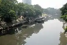
Adi Ganga
Adi Ganga, also known as Gobindapur Creek, Surman's Nullah and Tolly's Nullah, was the main flow of the Hooghly River from the 15th to 17th century but has subsequently virtually dried up.[1]

History
The earlier course of the lower Ganges as it flowed through the Bhagirathi channel was somewhat different from what its flow at the beginning of the 21st century. At Tribeni, near Bandel, it branched into three streams. The Saraswati flowed in a south-westerly direction, past Saptagram. The Jamuna (not the same river as in north India or many streams of that name in eastern Bengal) flowed in a south-easterly direction. The Hooghly flowed in the middle. The Hooghly glided down to near where Kolkata now stands and then flowed through the Adi Ganga, past Kalighat, Baruipur and Magra (of Sagar island) to the sea.[2]
In the 16th century, the main waters of the Bhagirathi, which earlier used to flow through the Saraswati, began to flow through the Hooghly. The upper Saraswati became a dead/dry river and the Hooghly abandoned the Adi Ganga channel and adopted the lower course of the Saraswati to flow to the sea.[2]
In his Manasamangal, Bipradas Pipilai has described the journey path of Chand Saudagor, the merchant, as passing Chitpur, Betore, Kalighat, Churaghat, Boral, Rajpur, Harinavi, Mahinagar, Baruipur, Jaynagar, Majilpur, Chhatrabhog, Badrikunda, Hathiagarh, Choumukhi, Satamukhi and Sagarsangam. The description of Bipradas Piplai tallies to a large extent with Van den Brouck's map of 1660.[3]
Some quarters ascribe the virtual drying up of Adi Ganga to the artificial link to the lower channel of the Saraswati, whereby that became the main channel for oceangoing ships and the Adi Ganga became derelict. This feat is ascribed by some to Nawab Alivardi Khan.[4] Others think that a tidal creek connecting the Saraswati and the Hooghly, near the point where the Adi Ganga branched off was the cause. It is rumoured that Dutch traders re-sectioned this tidal creek to let seagoing vessels come up the Bhagirathi.[5]
In earlier times no stream flowed from Khiderpore to Sankrail.[6] Ain-i-I Akbari[7] of Abul Fazal mentioned this fact. Dutch traders were involved in creating the Hooghly-Saraswati river connection. Documents found in Rotterdam municipality archive indicate the presence of Bank Zoll and Tank Zoll. Zoll is the Dutch word for Toll, implying that they set up a toll collection point along the connected waterway in the middle of the 18th century.
18th century
Adi Ganga was known earlier as Gobindapur Creek and marked the southern boundary of Gobindapur village. It was excavated by Edward Surman, who led a group to Delhi in 1717. The nullah was deepened by Colonel William Tolly in 1773 and connected to the Circular Canal. Thereafter, it bore his name.[8] In 1775, Tolly connected the Adi Ganga to the Vidyadhari.[4]
19th-20th century
Since Tolly's renovation the Adi Ganga has remained navigable. However, the neglect of waterways in general and other factors such as population pressure and unplanned urbanisation caused further silting of Adi Ganga. It ultimately turned into a sewer channel for the south-western part of Kolkata.
21st century

The Adi Ganga flows by Tollygunge and Kudghat, Alipore, Bansdroni, Naktala, Garia, Boral, Mahamayatala, Narendrapur, Rajpur Sonarpur, Harinavi, Kodalia, Changaripota (now Shubhashgram), where it is also known as the "Tolly Nullah", then on to Mahinagar and Baruipur (earlier Atisara village), and gradually reaches Jaynagar and Majilpur. Ultimately, the Adi Ganga flows into the Bay of Bengal.[9]

The Kolkata Metro stretches from Dum Dum to Tollygunge underground, except for the two terminal stations. A decision was made to extend the southern end of the Metro by 8.5 kilometres (5.3 mi) to New Garia with the extension on an elevated track. The Tollygunge-New Garia section runs over elevated track running over and along the Adi Ganga. The railway track is laid over a row of concrete pillars on the bed of Adi Ganga. Except the terminal one, all the five stations on this new stretch are elevated. Social activists believe that Metro railway's construction activity will result destroy the river.[5]
Adi Ganga became the focus of a number of community environmental initiatives. Suggestions have been made for the revival of Adi Ganga.[5]
References
- Roy, Niharranjan, Bangalir Itihas, Adi Parba, (in Bengali), first published 1972, reprint 2005, p. 126, Dey’s Publishing, 13 Bankim Chatterjee Street, Kolkata, ISBN 81-7079-270-3
- Majumdar, Dr. R.C., History of Ancient Bengal, First published 1971, Reprint 2005, pp. 2-3, Tulshi Prakashani, Kolkata, ISBN 81-89118-01-3.
- Roy, Niharranjan, p. 76
- Bandopadhyay, Dilip Kumar, Bharater Nadi (Rivers of India), 2002, (in Bengali), p. 69.
- Chakraborty, Satyesh C. "The Story of River Port". Kolkata Port Trust. Archived from the original on 21 July 2011. Retrieved 10 December 2007.
- Jelar Itihas Sudhir kumar Mitra/ page no 792 (original book) internet page 806.
- Abū al-Faz̤l ibn Mubārak, 1551-1602; Blochmann, H. (Henry) (1873). The Ain I Akbari. Harvard University. Calcutta : Asiatic Society of Bengal.CS1 maint: numeric names: authors list (link)
- Cotton, H.E.A., Calcutta Old and New, 1909/1980, pp.35, 226, General Printers and Publishers Pvt. Ltd.
- Das, Soumitra (5 July 2009). "River of time". The Telegraph. Calcutta, India.