Ambrus, Lot-et-Garonne
Ambrus is a commune in the Lot-et-Garonne department in southwestern France.
Ambrus | |
|---|---|
Location of Ambrus 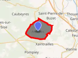
| |
 Ambrus  Ambrus | |
| Coordinates: 44°13′44″N 0°14′38″E | |
| Country | France |
| Region | Nouvelle-Aquitaine |
| Department | Lot-et-Garonne |
| Arrondissement | Nérac |
| Canton | Lavardac |
| Intercommunality | Confluent et Coteaux de Prayssas |
| Government | |
| • Mayor (2014-2020) | Christian Lafougère |
| Area 1 | 12.35 km2 (4.77 sq mi) |
| Population (2017-01-01)[1] | 113 |
| • Density | 9.1/km2 (24/sq mi) |
| Time zone | UTC+01:00 (CET) |
| • Summer (DST) | UTC+02:00 (CEST) |
| INSEE/Postal code | 47008 /47160 |
| Elevation | 68–175 m (223–574 ft) (avg. 120 m or 390 ft) |
| 1 French Land Register data, which excludes lakes, ponds, glaciers > 1 km2 (0.386 sq mi or 247 acres) and river estuaries. | |
Population
| Year | Pop. | ±% |
|---|---|---|
| 1793 | 225 | — |
| 1800 | 120 | −46.7% |
| 1806 | 261 | +117.5% |
| 1821 | 312 | +19.5% |
| 1831 | 326 | +4.5% |
| 1836 | 335 | +2.8% |
| 1841 | 322 | −3.9% |
| 1846 | 320 | −0.6% |
| 1851 | 303 | −5.3% |
| 1856 | 302 | −0.3% |
| 1861 | 290 | −4.0% |
| 1866 | 294 | +1.4% |
| 1872 | 289 | −1.7% |
| 1876 | 257 | −11.1% |
| 1881 | 229 | −10.9% |
| 1886 | 234 | +2.2% |
| 1891 | 214 | −8.5% |
| 1896 | 198 | −7.5% |
| 1901 | 181 | −8.6% |
| 1906 | 192 | +6.1% |
| 1911 | 148 | −22.9% |
| 1921 | 155 | +4.7% |
| 1926 | 133 | −14.2% |
| 1931 | 134 | +0.8% |
| 1936 | 126 | −6.0% |
| 1946 | 110 | −12.7% |
| 1954 | 115 | +4.5% |
| 1962 | 108 | −6.1% |
| 1968 | 92 | −14.8% |
| 1975 | 97 | +5.4% |
| 1982 | 81 | −16.5% |
| 1990 | 78 | −3.7% |
| 1999 | 71 | −9.0% |
| 2006 | 87 | +22.5% |
| 2009 | 97 | +11.5% |
References
- "Populations légales 2017". INSEE. Retrieved 6 January 2020.
| Wikimedia Commons has media related to Ambrus. |
| Authority control |
|---|
This article is issued from Wikipedia. The text is licensed under Creative Commons - Attribution - Sharealike. Additional terms may apply for the media files.