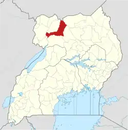
Amuru, Uganda
Amuru is a town in the Northern Region of Uganda. It is the main municipal, administrative, and commercial centre of Amuru District.
Amuru | |
|---|---|
 Amuru Location in Uganda | |
| Coordinates: 02°49′07″N 31°51′51″E | |
| Country | |
| Region | Northern Uganda |
| Sub-region | Acholi sub-region |
| District | Amuru District |
| Elevation | 3,000 ft (1,000 m) |
Location
Amuru is west of the main Gulu–Nimule Road, approximately 55 kilometres (34 mi), by road, west of Gulu, the largest city in the Acholi sub-region.[1] Amuru is located approximately 113 kilometres (70 mi) southwest of the town of Elegu, at the international border with South Sudan.[2]
This is about 352 kilometres (219 mi), by road, northwest of Kampala, Uganda's capital and largest city.[3] The coordinates of the town are 2°49'07.0"N, 31°51'51.0"E (Latitude:2.8186; Longitude:31.8642).[4]
Points of interest
The following additional points of interest lie within the town limits or close to the edges of the town:
- offices of Amuru Town Council
- Amuru central market
References
- Google (31 December 2020). "Road Distance Between Amuru, Uganda And Gulu, Uganda" (Map). Google Maps. Google. Retrieved 31 December 2020.
- Google (31 December 2020). "Road Distance Between Amuru, Uganda And Elegu, Uganda" (Map). Google Maps. Google. Retrieved 31 December 2020.
- Google (31 December 2020). "Road Distance Between Kampala, Uganda And Amuru, Uganda" (Map). Google Maps. Google. Retrieved 31 December 2020.
- Google (22 July 2015). "Location of Amuru Town, Northern Region, Uganda" (Map). Google Maps. Google. Retrieved 22 July 2015.
This article is issued from Wikipedia. The text is licensed under Creative Commons - Attribution - Sharealike. Additional terms may apply for the media files.
