Ariyalur
Ariyalur (Tamil: [aɾijaluːɾ]) is a town and district headquarters of Ariyalur district in the South Indian state of Tamil Nadu and rich limestone and surrounded with seven cement factories and two sugar factories . The town is located at a distance of 310 km (190 mi) from the state capital Chennai.
Ariyalur | |
|---|---|
Town | |
.JPG.webp) | |
| Nickname(s): Mecca for archeologist | |
 Ariyalur Location in Tamil Nadu, India | |
| Coordinates: 11°8′14″N 79°4′40″E | |
| Country | |
| State | Tamil Nadu |
| District | Ariyalur |
| Government | |
| • Type | Second Grade Municipality |
| • Body | Ariyalur Municipality |
| Elevation | 76 m (249 ft) |
| Population (2011) | |
| • Total | 28,902 |
| Languages | |
| • Official | Tamil |
| Time zone | UTC+5:30 (IST) |
| PIN | 621704,621713 |
| Telephone code | 91-4329 |
| Vehicle registration | TN 61 |
| Distance from Chennai | 267 kilometres (166 mi) |
| Distance from Trichy | 65 kilometres (40 mi) |
| Distance from Thanjavur | 42 kilometres (26 mi) |
| Precipitation | 830 millimetres (32.7 in) |
Ariyalur was a part of the erstwhile Trichinopoly District until India's independence in 1947 and Tiruchirappalli district until 1995, Perambalur district until 2007 and subsequently a part of the newly formed Ariyalur district. The town is a part of the fertile Cauvery Delta and the major profession in the town is agriculture.
Ariyalur is administered by a municipality established in 1994. As of 2011, the municipality covered an area of 7.62 km2 (2.94 sq mi) and had a population of 28,902. Ariyalur comes under the Ariyalur assembly constituency which elects a member to the Tamil Nadu Legislative Assembly once every five years and it is a part of the Chidambaram constituency which elects its Member of Parliament (MP) once in five years. Roadways are the major mode of transportation to the town and it also has rail connectivity which acts as a main station after Tiruchirappalli junction. The nearest seaport is Karaikal port, located 95 km (59 mi) away, while the nearest airport is the Tiruchirappalli International Airport, located 76 km (47 mi) away from the town.
History

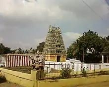
After the Chozha dynasty, Vijayanagar Nayak kings ruled and built many temples in Ariyalur Kothandaramar temple.
In 1741 the Marathas invaded Tiruchirappalli and took Chanda Saheb as captive. Chanda Saheb succeeded in securing freedom in 1748 and soon got involved in a famous war for the Nawabs place in the Carnatic against Anwardeen, the Nawab of Arcot and his son Mohammed Ali.
Mohammed Ali annexed the two palayams of Ariyalur and Udayarpalayam located with troops were in the Ariyalur district on the grounds of default in the payment of Tributes and failure to assist him in quelling the rebellion of Yusuf Khan. In November 1764, Mohammed Ali represented the issue to Madras Council and obtained military assistance on 3 January 1765. The forces led by Umdat-Ul-Umara and Donald Campbell entered Ariyalur and captured it. The young Poligar together with his followers thereupon fled to Udayarpalayam. On 19 January the army marched upon Udayarpalayam. The Poligar's troops were defeated and the playams were occupied. The two poligars fled their town and took refuge in Tharangampadi, then a Danish Settlement. The annexation of the palayam gave the Navab uninterrupted possession of all his territories extending Arcot to Tiruchirapalli.
The history followed was a power struggle between Hyder Ali and later Tipu Sultan with the British. After the death of Tipu Sultan the English took the civil and military Administration of the Carnatic in 1801. Thus Tiruchirappalli came into the hands of the English and the District was formed in 1801.
In 1995, Tiruchirappalli was trifurcated and the Perambalur and Karur districts were formed. Perambalur district was divided into Perambalur and Ariyalur districts in the year 2001 and merged with Perambalur in the year 2002. Then now the district is bifurcated from Perambalur and now functioning from 23.11.2007.
Geography
Ariyalur is a municipality and headquarters of Ariyalur District in the state of Tamil Nadu. It is rich in limestone resources.
Climate
| Climate data for Ariyalur (1981–2001) | |||||||||||||
|---|---|---|---|---|---|---|---|---|---|---|---|---|---|
| Month | Jan | Feb | Mar | Apr | May | Jun | Jul | Aug | Sep | Oct | Nov | Dec | Year |
| Record high °C (°F) | 42.0 (107.6) |
42.4 (108.3) |
42.4 (108.3) |
45.4 (113.7) |
48.4 (119.1) |
42.0 (107.6) |
41.5 (106.7) |
49.6 (121.3) |
44.4 (111.9) |
42.2 (108.0) |
42.2 (108.0) |
42.4 (108.3) |
49.6 (121.3) |
| Average high °C (°F) | 31.2 (88.2) |
33.2 (91.8) |
36.2 (97.2) |
38.2 (100.8) |
39.1 (102.4) |
37.5 (99.5) |
36.6 (97.9) |
36.2 (97.2) |
35.6 (96.1) |
34.5 (94.1) |
32.4 (90.3) |
31.3 (88.3) |
35.2 (95.4) |
| Average low °C (°F) | 21.1 (70.0) |
21.7 (71.1) |
23.8 (74.8) |
26.5 (79.7) |
26.9 (80.4) |
26.6 (79.9) |
26.2 (79.2) |
25.9 (78.6) |
24.9 (76.8) |
24.0 (75.2) |
22.7 (72.9) |
21.6 (70.9) |
24.3 (75.7) |
| Record low °C (°F) | 15.2 (59.4) |
13.0 (55.4) |
15.2 (59.4) |
20.0 (68.0) |
15.6 (60.1) |
21.9 (71.4) |
19.4 (66.9) |
20.6 (69.1) |
19.8 (67.6) |
18.2 (64.8) |
13.0 (55.4) |
15.2 (59.4) |
13.0 (55.4) |
| Average rainfall mm (inches) | 15.4 (0.61) |
8.0 (0.31) |
7.1 (0.28) |
35.1 (1.38) |
35.9 (1.41) |
18.1 (0.71) |
41.0 (1.61) |
69.2 (2.72) |
97.6 (3.84) |
99.6 (3.92) |
100.4 (3.95) |
91.2 (3.59) |
618.6 (24.35) |
| Average rainy days | 1.0 | 0.5 | 0.5 | 0.8 | 1.8 | 1.0 | 2.7 | 3.5 | 5.3 | 5.9 | 5.4 | 4.4 | 32.8 |
| Average relative humidity (%) (at 17:30 IST) | 69 | 60 | 52 | 50 | 52 | 52 | 53 | 57 | 63 | 72 | 77 | 75 | 61 |
| Source: India Meteorological Department[1] | |||||||||||||
Economy
Big industrial houses like Birlas (UltraTech Cement), India Cements, Dalmia Cement, Madras Cement have their cement units here. Tamil Nadu government's TANCEM factory is in Ariyalur and is the first factory to establish the cement production in ariyalur.
Sugar cane is grown as a major commercial crop. One private sugar factory near Keelapalur is functioning in the district with a capacity of crushing 3,000 Tonnes per day. One of the main crops in Ariyalur district is cashew. The pre-dominate soil in the district is red sanding with scattered Packers of black soil. This town consists mainly of glade soil. The soil in the district is best suited for raising dry crops. Rice also grown in some places.
Administration and politics
| Municipality Officials | |
|---|---|
| Chairman | [2] |
| Commissioner | K. Sudha[3] |
| Vice Chairman | M. Malarkodi[4] |
| Elected Members | |
| Member of Legislative Assembly | Thamarai.S.Rajendran[5] |
| Member of Parliament | M. Chandrakasi[6] |
The municipality of Ariyalur was established as a second grade town panchayat from 1943 during British rule. It was promoted to a first grade town panchyat in 1995, to a second grade in 1966 and a special grade in October 2004. Jayankondam is the first Municipality in Ariyalur district. During December 2004, it was promoted to a third grade municipality.[7] As of 2008, the municipality covered an area of 7.62 km2 (2.94 sq mi) and had a total of 18 members. The functions of the municipality is devolved into six departments: General, Engineering, Revenue, Public Health, Town planning and the Computer Wing. All these departments are under the control of a Municipal Commissioner who is the supreme executive head.[8] The legislative powers are vested in a body of 18 members, one each from the 18 wards. The legislative body is headed by an elected Chairperson assisted by a Deputy Chairperson.[9] The municipality had an estimated income of ₹75,917,000 and an estimated expenditure of ₹63,703,000 for the year 2012–13.[10]
Ariyalur comes under the Ariyalur State Assembly Constituency and it elects a member to the Tamil Nadu Legislative Assembly once every five years.[11][12] From the 1977 elections, the assembly seat was won by Dravida Munnetra Kazhagam (DMK) three times during the 1977, 1980 and 1989 elections, the All India Anna Dravida Munnetra Kazhagam (AIADMK) two times during the 2001 and 2011 elections, Indian National Congress once during 2006 and Tamil Maanila Congress once during the 1996 elections.[13] The current Member of Legislative Assembly (MLA) of the constituency is Thamarai S.Rajendran from the AIADMK Party.[5] Ariyalur is a part of the Chidambaram Lok Sabha constituency and elects a member to the Lok Sabha, the lower house of the Parliament of India, once every five years.[6][12] The current Member of Parliament from the constituency is M. Chandrakasi from the ADMK party.[6]

Demographics
| Year | Pop. | ±% |
|---|---|---|
| 1971 | 17,305 | — |
| 1981 | 20,635 | +19.2% |
| 1991 | 24,141 | +17.0% |
| 2001 | 27,822 | +15.2% |
| 2011 | 28,902 | +3.9% |
According to 2011 census, Ariyalur had a population of 28,902 with a sex-ratio of 1,014 females for every 1,000 males, much above the national average of 929.[16] A total of 2,977 were under the age of six years, constituting 1,538 males and 1,439 females. Scheduled Castes and Scheduled Tribes accounted for 11.26% and 0.03% of the population respectively. The average literacy of the town was 76.04%, compared to the national average of 72.99%.[16] The town had a total of 7,319 households. There were a total of 10,283 workers, comprising 315 cultivators, 670 main agricultural labourers, 298 in house hold industries, 7,165 other workers, 1,835 marginal workers, 159 marginal cultivators, 175 marginal agricultural labourers, 150 marginal workers in household industries and 1,351 other marginal workers.[15] As of 2008, there were a total of eight notified slums, with 5,907 comprising 21% of the total population residing in those.[17] As per the religious census of 2011, Ariyalur had 80.55% Hindus, 4.61% Muslims, 3.81% Christians, 10.02% Sikhs, 0.01% Buddhists, 0.01% Jains, 0.97% following other religions and 0.01% following no religion or did not indicate any religious preference.[18]
Utility services
Electricity supply to Ariyalur is regulated and distributed by the Tamil Nadu Electricity Board (TNEB). The town along with its suburbs forms the Trichy Electricity Distribution Circle.[19] Water supply is provided by the municipality of Ariyalur from Kollidam river through three schemes with head works of two of them located at Thirumanur. In the period 2010–2011, a total of 2.3 million litres of water was supplied everyday for households in the town. There are three bore wells and 356 water fountains in the town that serves as the source of groundwater.[20] About 11 metric tonnes of solid waste are collected from Ariyalur every day by door-to-door collection out of the 15 metric tonnes generated and subsequently the source segregation and dumping is carried out by the sanitary department of the municipality. The coverage of solid waste management had an efficiency of 73% as of 2001.[21] There is limited underground drainage system in the town and the major sewerage system for disposal of sullage is through septic tanks, open drains and public conveniences.[22] The municipality maintains a total of 25.16 km (15.63 mi) of storm water drains in Ariyalur, out of which 7.93 km (4.93 mi) are open drains and 17.23 km (10.71 mi) are unpaved drains.[23] There is a government hospital and twelve private hospitals and clinics that take care of the healthcare needs of the citizens.[24] There are a total of 1,501 street lamps in Ariyalur: 361 sodium lamps, 1,139 tube lights and one high mast beam lamp.[25] The municipality operates one fish and meat market that has 46 shops and a weekly market that cater to the needs of the town and the rural areas around it.[26]
Transportation

The National Highway NH136 connects Perambalur and Thanjavur, passes through Ariyalur, State Highways SH143 - Ariyalur- Thungapuram - Thittakudi and SH139 Ariyalur - Rettipalayan are the major roads via Ariyalur. The Ariyalur municipality maintains a total length of 29.17 km (18.13 mi). The town has 3.2 km (2.0 mi) concrete roads, 16.2 km (10.1 mi) BT roads, 4 km (2.5 mi) of WBM roads and 5.77 km (3.59 mi) earthen roads. A total of 452 roads is maintained by the State Highways Department.[27] Ariyalur is served by town bus service, which provides connectivity within the town and the suburbs. There are private operated mini-bus services that cater to the local transport needs of the town. The town has a B-class bus stand located in the heart of the town.[27] There are regular inter-city bus services to Ariyalur. The Tamil Nadu State Transport Corporation operates daily services connecting various cities to Ariyalur. The major inter city bus routes from the town are to cities and towns like Trichy, Chidambaram, Jayankondam, Perambalur and Thanjavur.[28] Ariyalur railway station is located on the line between the state capital Chennai and Trichy and is well connected by rail to major towns like Madurai and Thoothukudi.[28] The nearest seaport is Karaikal port, located 95 km (59 mi) away, while the nearest airport is the Tiruchirappalli International Airport, located 76 km (47 mi) away from the town.[28]
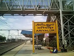
Ariyalur railway station is a major railway station on chord line connecting Chennai and Tiruchirappalli. Several daily trains such as Pallavan Express, Rockfort Express, Pearl City Express, Vaigai Express etc. connect Ariyalur with Chennai Egmore and Tiruchirappalli Junction.
See also
- Vadaveekam
- Kallathur
NOTES
- "Station: Ariyalur Climatological Table 1981–2010" (PDF). Climatological Normals 1981–2010. India Meteorological Department. January 2015. pp. 51–52. Archived from the original (PDF) on 5 February 2020. Retrieved 7 March 2020.
- "Chairman of Ariyalur". Ariyalur Municipality, Government of Tamil Nadu. 2011. Archived from the original on 12 January 2013. Retrieved 1 January 2014.
- "Commissioner of Ariyalur". Ariyalur Municipality, Government of Tamil Nadu. 2012. Archived from the original on 28 May 2014. Retrieved 1 January 2014.
- "Vice Chairman of Ariyalur". Ariyalur Municipality, Government of Tamil Nadu. 2011. Archived from the original on 12 January 2013. Retrieved 1 January 2014.
- "MLA of Ariyalur". Government of Tamil Nadu. 2012. Archived from the original on 6 October 2013. Retrieved 1 January 2014.
- "Members of Lok Sabha from Tamil Nadu". Government of Tamil Nadu. 2014. Retrieved 26 May 2014.
- "About Ariyalur Municipality". Ariyalur Municipality. Archived from the original on 29 October 2013. Retrieved 1 January 2014.
- "Commissionerate of Municipal Administration". Commissionerate of Municipal Administration. Archived from the original on 6 November 2012. Retrieved 1 January 2014.
- Economic and political weekly 1995, p. 2396
- "Budget 2010–11" (in Tamil). Ariyalur Municipality. p. 1. Archived from the original (PDF) on 29 October 2013. Retrieved 1 January 2014.
- "List of Assembly Constituencies". Tamil Nadu. Tamil Nadu state government. 2010. Archived from the original on 14 June 2012. Retrieved 1 January 2014.
- "Map showing the new assembly constituencies" (PDF). Election Commission of India. p. 1. Retrieved 1 January 2014.
- "Partywise Comparison Since 1977". Election Commission of India. 2011. Retrieved 1 January 2014.
- Urban Infrastructure Report 2009, pp. 4-5
- "Census Info 2011 Final population totals - Ariyalur". Office of The Registrar General and Census Commissioner, Ministry of Home Affairs, Government of India. 2013. Retrieved 26 January 2014.
- "Census Info 2011 Final population totals". Office of The Registrar General and Census Commissioner, Ministry of Home Affairs, Government of India. 2013. Retrieved 26 January 2014.
- Urban Infrastructure Report 2009, p. 34
- "Population By Religious Community - Tamil Nadu" (XLS). Office of The Registrar General and Census Commissioner, Ministry of Home Affairs, Government of India. 2011. Retrieved 13 September 2015.
- "Important Address" (PDF). Indian Wind Power Association. 2011. p. 3. Archived from the original (PDF) on 16 October 2012. Retrieved 1 January 2014.
- Urban Infrastructure Report 2008, p. 22
- "Waste management programme". Ariyalur Municipality. 2011. Archived from the original on 28 May 2014. Retrieved 1 January 2014.
- Urban Infrastructure Report 2008, p. 24
- Urban Infrastructure Report 2008, p. 25
- "Ariyalur hospitals". Ariyalur municipality, Government of Tamil Nadu. 2011. Archived from the original on 1 August 2008. Retrieved 1 January 2014.
- "Ariyalur street lighting". Ariyalur municipality, Government of Tamil Nadu. 2011. Archived from the original on 28 May 2014. Retrieved 1 January 2014.
- Urban Infrastructure Report 2008, p. 35
- Urban Infrastructure Report 2008, p. 31
- "Ariyalur bus routes". Ariyalur municipality. 2011. Archived from the original on 28 May 2014. Retrieved 29 December 2012.
References
- Urban Infrastructure report (2008). Conversion of City Corporate Plan into Business Plan (PDF) (Report). Tamil Nadu Urban Infrastructure Financial Services Limited. Archived from the original (PDF) on 16 September 2012. Retrieved 27 May 2014.

