Attwood, Victoria
Attwood is a suburb of Melbourne, Victoria, Australia, 18 km north-west from Melbourne's central business district. Its local government area is the City of Hume. At the 2016 Census, Attwood had a population of 3,419.[1]
| Attwood Melbourne, Victoria | |||||||||||||||
|---|---|---|---|---|---|---|---|---|---|---|---|---|---|---|---|
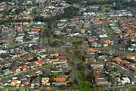
 Houses in Attwood, Victoria (2017) | |||||||||||||||
 Attwood | |||||||||||||||
| Coordinates | 37.666°S 144.887°E | ||||||||||||||
| Population | 3,419 (2016 census)[1] | ||||||||||||||
| • Density | 1,368/km2 (3,540/sq mi) | ||||||||||||||
| Postcode(s) | 3049 | ||||||||||||||
| Area | 2.5 km2 (1.0 sq mi) | ||||||||||||||
| Location |
| ||||||||||||||
| LGA(s) | City of Hume | ||||||||||||||
| State electorate(s) | Yuroke | ||||||||||||||
| Federal Division(s) | Calwell | ||||||||||||||
| |||||||||||||||

Police campus, with police dog kennels in the foreground, and driving range behind
Attwood is home to Victoria Police's driver training track, Dog Squad and Mounted Branch. The Melway describes this area as ‘Strictly out of Bounds’. The suburb is located south of Greenvale, along Mickleham Road.
See also
- Shire of Bulla - the former local government area of which Attwood was a part
References
- Australian Bureau of Statistics (27 June 2017). "Attwood (State Suburb)". 2016 Census QuickStats. Retrieved 2 July 2017.

This article is issued from Wikipedia. The text is licensed under Creative Commons - Attribution - Sharealike. Additional terms may apply for the media files.