Batu Uban
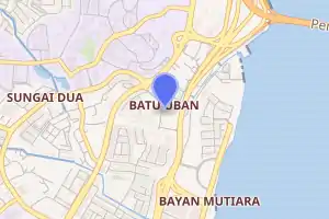
Batu Uban is a residential neighbourhood at the eastern coast of Penang Island in Malaysia, about 6.7 km (4.2 mi) south of the centre of George Town, Penang's capital city, and adjacent to the Gelugor suburb. Founded by ethnic Minangkabaus in the early 18th century, Batu Uban is regarded as the oldest Malay settlement on Penang Island.[1][2]
Batu Uban | |
|---|---|
| Other transcription(s) | |
| • Jawi | باتو اوبن |
| • Chinese | 峇都蛮 |
| • Hokkien | bâ to͘ bân |
 | |

| |
 Batu Uban | |
| Coordinates: 5°21′25.5522″N 100°18′37.5906″E | |
| Country | |
| State | |
| District | Northeast Penang Island |
| City | |
| Government | |
| • Local government | Penang Island City Council |
| • Mayor of Penang Island | Yew Tung Seang |
| • Batu Uban State Assemblyman | Kumaresan Aramugam (PKR) |
| • Bayan Baru Member of Parliament | Sim Tze Tzin (PKR) |
| Time zone | UTC+8 (MST) |
| • Summer (DST) | Not observed |
| Postal code | 11700 |
| Website | mbpp |
Since the late 20th century, Batu Uban has been significantly urbanised, with residential high-rises now dotting the neighbourhood.[1][3][4][5]
Etymology
Batu Uban means grey hair rock in Malay. The area was said to have been named after a sea boulder, which was covered in dried grass, off the coast of what is now Batu Uban; this grassy rock resembled white hair from afar.[1]
History
The establishment of Batu Uban is credited to two ethnic Minangkabaus from Sumatra – Haji Muhammad Salleh (also known as Nakhoda intan) and Jenaton Raha Labu. In 1734, Haji Muhammad Salleh and his followers landed at the area and built a mosque named Masjid Jamek; this also makes the mosque the oldest in Penang.[1][2] The fishing village they founded was also centred around the mosque.
In 1749, Dato' Jenaton Raja Labu from Pagarruyung was granted a 100-acre (40 ha) site at Batu Uban by the Sultan of Kedah, as a reward for his assistance in thwarting a Siamese invasion of Kedah; Penang Island was part of Kedah at the time.[1] Jenaton and about 90 followers then travelled to Batu Uban, and cultivated the land into coconut and sugar cane plantations. Jenaton was also said to have contributed to the propagation of Islam within this new settlement.[2]
The founding of Batu Uban between 1734 and 1749 by the Minangkabaus makes it the oldest Malay settlement on Penang Island, predating Captain Francis Light's arrival on the island in 1786. However, it was only in the late 20th century when Batu Uban began to witness significant development. The completion of the Penang Bridge immediately north of Batu Uban in the 1980s and subsequently, the Tun Dr Lim Chong Eu Expressway along the coast of Batu Uban, heralded the development of Batu Uban as an affluent residential neighbourhood.[1][5]
Transportation

Rapid Penang bus routes 301, 302, 303 and 304 include stops along Jalan Sultan Azlan Shah, which forms the western limits of the Batu Uban neighbourhood.[6][7][8][9] These routes link Batu Uban with George Town to the north and other southerly destinations on Penang Island, such as Bukit Jambul, Bayan Baru, Bayan Lepas and Batu Maung.
In addition, Batu Uban, situated immediately south of the cross-strait Penang Bridge, is easily accessible for motorists from the mainland Malay Peninsula as well.
Education
Penang Island's sole public university, Universiti Sains Malaysia, is located immediately northwest of the Batu Uban neighbourhood. The university was ranked fifth within Malaysia by the QS World University Rankings as of 2016.[10]
References
- "Earliest Malay settlement in Penang – Community | The Star Online". www.thestar.com.my. Retrieved 2017-05-23.
- "USM News Portal – BATU UBAN PETEMPATAN AWAL ORANG PULAU PINANG". news.usm.my. Retrieved 2017-05-23.
- "www.propertyguru.com.my/condo/condo-718". www.propertyguru.com.my. Retrieved 2017-05-23.
- "www.propertyguru.com.my/condo/e-park-condominium-717". www.propertyguru.com.my. Retrieved 2017-05-23.
- "Specially crafted for serene living – Community | The Star Online". www.thestar.com.my. Retrieved 2017-05-23.
- http://www.rapidpg.com.my/journey-planner/route-maps/details/301.gif
- http://www.rapidpg.com.my/journey-planner/route-maps/details/302.gif
- http://www.rapidpg.com.my/journey-planner/route-maps/details/303.gif
- "Archived copy". Archived from the original on 2016-07-02. Retrieved 2017-05-23.CS1 maint: archived copy as title (link)
- "QS World University Rankings 2016". Top Universities. 2016-08-25. Retrieved 2017-05-19.