Binbrook
Binbrook is a village and civil parish in the East Lindsey district of Lincolnshire, England. It is situated on the B1203 road, and 8 miles (13 km) north-east from Market Rasen.
| Binbrook | |
|---|---|
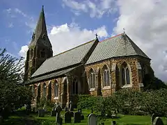
 Church of St Mary and St Gabriel, Binbrook | |
 Binbrook Location within Lincolnshire | |
| Population | 892 (2011) |
| OS grid reference | TF210940 |
| • London | 130 mi (210 km) s |
| District | |
| Shire county | |
| Region | |
| Country | England |
| Sovereign state | United Kingdom |
| Post town | Market Rasen |
| Postcode district | LN8 |
| Dialling code | 01472 |
| Police | Lincolnshire |
| Fire | Lincolnshire |
| Ambulance | East Midlands |
| UK Parliament | |
Previously a larger market town,[1] it now has a population of about 700, rising to 892 at the Census 2011.[2]
Binbrook Grade II listed[3] Anglican parish church is dedicated to St Mary and St Gabriel. There were two village churches, St Mary and St Gabriel, since disappeared. A new church with joint dedication was built in 1869 by James Fowler.[1][4]
Binbrook is close to the site of Binbrook Airfield, originally opened as RAF Binbrook; the airfield housing is now the new village of Brookenby.
Governance
An electoral ward in the same name exists. This ward stretches south east to Fotherby with a total population taken at the 2011 census of 1,831.[5]
Orford
The parish of Binbrook contains the site of the lost medieval village of Orford.[6] Orford was the site of a priory of Premonstratensian nuns. The priory was founded around 1170 by Ralf d'Albini of the Anglo-Norman baronial house of Mowbray, and was endowed with the church at Wragby. At the time of suppression in 1539 it held a prioress and 7 nuns.[1]
References
- Cox, J. Charles (1916) Lincolnshire pp. 64-65; Methuen & Co. Ltd
- "Parish population 2011". Neighbourhood Statistics. Office for National Statistics. Retrieved 18 August 2015.
- Historic England. "Church of St Mary and St Gabriel (1063134)". National Heritage List for England. Retrieved 29 June 2011.
- Pevsner, Nikolaus; Harris, John; The Buildings of England: Lincolnshire p. 191; Penguin (1964); revised by Nicholas Antram in 1989, Yale University Press. ISBN 0-300-09620-8
- "Key Figures for 2011 Census: Key Statistics – Area: Binbrook (Ward)". Neighbourhood Statistics. Office for National Statistics. Retrieved 28 October 2016.
- Historic England (2007). "Orford (351872)". PastScape. Retrieved 10 April 2010.
External links
![]() Media related to Binbrook at Wikimedia Commons
Media related to Binbrook at Wikimedia Commons
- "Binbrook", Genuki.org.uk; retrieved 29 June 2011
- Village web site
- Binbrook CoE Primary School
- St Mary & St Gabriel Church