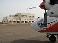
Bobo Dioulasso Airport
Bobo Dioulasso Airport (IATA: BOY, ICAO: DFOO) is an international airport in Bobo Dioulasso, Burkina Faso.
Bobo Dioulasso Airport | |||||||||||
|---|---|---|---|---|---|---|---|---|---|---|---|
 | |||||||||||
| Summary | |||||||||||
| Airport type | Public | ||||||||||
| Operator | Government | ||||||||||
| Serves | Bobo Dioulasso, Burkina Faso | ||||||||||
| Elevation AMSL | 1,511 ft / 461 m | ||||||||||
| Coordinates | 11°09′36.479″N 004°19′51.121″W | ||||||||||
| Map | |||||||||||
 BOY Location within Burkina Faso | |||||||||||
| Runways | |||||||||||
| |||||||||||
The airport has commercial flights to Ouagadougou and to the Ivory Coast.
DFOO is served by a VOR/DME and NDBs and Runway 06 has a Category I ILS. There are also GNSS, VOR and ADF approaches to each runway.
Airlines and destinations
| Airlines | Destinations |
|---|---|
| Air Burkina | Abidjan, Ouagadougou |
References
- Entry for Bobo Dioulasso Airport in ASECNA AIP Accessed 2017-05-26
- Airport information for DFOO at World Aero Data. Data current as of October 2006.Source: DAFIF.
- Airport information for DFOO at Great Circle Mapper. Source: DAFIF (effective October 2006).
External links
- Official ASECNA Aeronautical Publication for Burkina Faso
- Current weather for DFOO at NOAA/NWS
- Accident history for BOY at Aviation Safety Network
This article is issued from Wikipedia. The text is licensed under Creative Commons - Attribution - Sharealike. Additional terms may apply for the media files.