Bolvadin
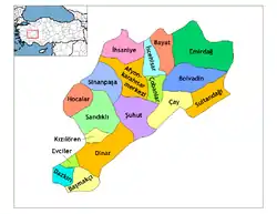
Bolvadin (Ancient Greek: Πολύβοτον/Πολύβοτος and Latin: Polybotum/Polybotus) is a city and district of Afyonkarahisar Province in Turkey. It covers an area of 1,108 km² and has an altitude of 1,016 m. The population of the district center is 31,387 (2010). The mayor is Fatih Kayacan (Ak Party).
Bolvadin | |
|---|---|
 Bolvadin | |
| Coordinates: 38°43′N 31°3′E | |
| Country | |
| Province | Afyonkarahisar |
| Area | |
| • District | 1,152.64 km2 (445.04 sq mi) |
| Population (2012)[2] | |
| • Urban | 31,810 |
| • District | 45,694 |
| • District density | 40/km2 (100/sq mi) |
| Climate | Csb |
Bolvadin is the largest town in the province apart from the city of Afyon itself, built on a large fertile plain between the mountains of Sultandağ and Emirdağ inland from the Aegean coast.
History
The city was founded in very early times. It was part of Phrygia. In the Roman era it was known as Polybotum and a castle was built here. It then passed into the hands of the Seljuk Turks and then the Ottoman Empire, known as a strategic bridge in the mountains.
Bolvadin was occupied by Greek troops during the Turkish War of Independence, until September 1922.
Bolvadin today
The plain is watered by the river Akarçay and is a rich agricultural land. Opium was grown in the area and is still grown today; there is a factory here producing morphine for the pharmaceutical industry. However today the plain is also used for growing grain and fruit. The higher mountainside is forested. The climate is hot in summer, cold enough to snow in winter. Lake Eber lies at the south-east edge of the plain, 967 m above sea level. Carp fishing and cutting rushes contribute to the economy of this farming district. This is not a rich region, it lacks infrastructure such as public transport and the people of Bolvadin are conservative.
Bolvadin is renowned for its cream made of buffalo milk.
The area is vulnerable to earthquakes.
References
- "Area of regions (including lakes), km²". Regional Statistics Database. Turkish Statistical Institute. 2002. Retrieved 2013-03-05.
- "Population of province/district centers and towns/villages by districts - 2012". Address Based Population Registration System (ABPRS) Database. Turkish Statistical Institute. Retrieved 2013-02-27.
External links
- Municipality of Bolvadin (in Turkish)
