Brass, Nigeria
Brass is a Local Government Area in Bayelsa State, Nigeria. Its headquarters are in the town of Twon-Brass on Brass Island along the coast. It has a coastline of approximately 90 km on the Bight of Bonny. Much of the area of the LGA is occupied by the Edumanom National Forest.
Brass | |
|---|---|
 Brass Location in Nigeria | |
| Coordinates: 4°18′54″N 6°14′30″E | |
| Country | |
| State | Bayelsa State |
| Headquarters | Twon-Brass |
| Government | |
| • Type | LGA |
| Area | |
| • Total | 1,404 km2 (542 sq mi) |
| Population (2006 census) | |
| • Total | 185,049 |
| Time zone | UTC+1 (WAT) |
| 3-digit postal code prefix | 562 |
| ISO 3166 code | NG.BY.BR |
It has an area of 1,404 km2 and a population of 185,049 at the 2006 census.
The postal code of the area is 562.[1]
References
- "Post Offices- with map of LGA". NIPOST. Archived from the original on 2009-10-07. Retrieved 2009-10-20.
State capital: Yenagoa | ||
| Local Government Areas | 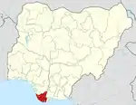 | |
This article is issued from Wikipedia. The text is licensed under Creative Commons - Attribution - Sharealike. Additional terms may apply for the media files.