Buford Mountain Conservation Area
Buford Mountain Conservation Area consists of 3,824 acres (15.48 km2) north of Ironton and southwest of Bismarck, Missouri. The area includes Buford Mountain at 1,740 feet (530 m) above sea level. The mountain consists mostly of rhyolite, with few permanent water sources. However, there are eight fishless ponds each about 0.25 acres (0.10 ha) in size.
| Buford Mountain Conservation Area | |
|---|---|
IUCN category IV (habitat/species management area) | |
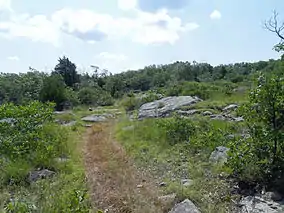
 Buford Mountain Trail on Bald Knob | |
 | |
| Location | Iron and Washington counties, Missouri, United States |
| Nearest city | Bismarck, MO |
| Coordinates | 37.714339°N 90.703133°W |
| Area | 3,824 acres (15.5 km2) |
| Established | 1983 |
| Governing body | Missouri Department of Conservation |
| Official website | |
The central feature, Buford Mountain, has the name of the local Buford family who settled the area.[1] The Missouri Department of Conservation purchased the area from the Nature Conservancy in 1979. There is a hiking trail that traverses the area for 10.5 miles (16.9 km) and crosses the summit of Buford Mountain. Hunting is permitted in the area in the appropriate season with permits.[2]

View west from Bald Knob

Buford Mountain viewed from Belleview Valley looking east
See also
References
| Wikimedia Commons has media related to Buford Mountain Conservation Area. |
- "Iron County Place Names, 1928–1945 (archived)". The State Historical Society of Missouri. Archived from the original on 24 June 2016. Retrieved 11 October 2016.CS1 maint: bot: original URL status unknown (link)
- "Buford Mountain Conservation Area". Missouri Department of Conservation. Archived from the original on February 22, 2013. Retrieved October 31, 2012.
This article is issued from Wikipedia. The text is licensed under Creative Commons - Attribution - Sharealike. Additional terms may apply for the media files.