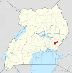
Butaleja
Butaleja is a town in Eastern Rgion of Uganda. It is the main municipal, administrative and commercial center of Butaleja District and the district headquarters are located there. The district is named after the town.[2]
Butaleja | |
|---|---|
 Butaleja Location in Uganda | |
| Coordinates: 00°55′30″N 33°56′42″E | |
| Country | |
| Region | Eastern Uganda |
| District | Butaleja District |
| Elevation | 3,600 ft (1,100 m) |
| Population (2020 Estimates) | |
| • Total | 24,000[1] |
Location
Butaleja is located approximately 42.5 kilometres (26 mi), by road, southwest of Mbale, the largest city in Uganda's Eastern Region.[3] This is approximately 48 kilometres (30 mi) northwest of Tororo, in Tororo District, the nearest large town.[4]
Butaleja is located about 254 kilometres (158 mi), by road, northeast of Kampala, the capital of Uganda and the largest city in that country.[5] The coordinates of the town are:0°55'30.0"N, 33°56'42.0"E (Latitude:0.9250; Longitude:33.9450).[6] Butaleja Town Council sits at an average elevation of 1,100 metres (3,600 ft) above mean sea level.[7]
Population
In 2010, the Uganda Bureau of Statistics (UBOS), estimates the town's population at 5,500. In 2011, UBOS estimated the mid-year population of the town at 5,700.[8] In 2014, the national population census put the population of Butaleja at 19,561.[9]
In 2015, UBOS estimated the population of Butaleja Town Council at 20,200. In 2020, the population agency estimated the mid-year population of the town at 24,000. Of these, 12,000 (50 percent) were females and another 12,000 (50 percent) were males. UBOS calculated the population growth rate of Butaleja Town to average 3.51 percent, annually, between 2015 and 2020.[1]
Points of interest
The following points of interest lie within town:[6]
1. The headquarters of Butaleja District Administration
2. Butaleja Central Market
3. A mobile branch of PostBank Uganda
4. The offices of Butaleja Town Council
References
- Citypopultion.de (14 June 2020). "Estimated Population of Butaleja Town Council" (Citypopulation.de Quoting Uganda Bureau of Statistics). Citypopulation.de. Retrieved 20 January 2021.
- Office of the Prime Minister of Uganda (2016). "Profile of Butaleja District, Eastern Region, Uganda" (PDF). Kampala: Office of the Prime Minister of Uganda. Retrieved 20 January 2021.
- Google (20 January 2021). "Road Distance Between Butaleja, Uganda And Mbale, Uganda" (Map). Google Maps. Google. Retrieved 20 January 2021.
- Google (20 January 2021). "Road Distance Between Tororo, Uganda And Butaleja, Uganda" (Map). Google Maps. Google. Retrieved 20 January 2021.
- Google (20 January 2020). "Map Showing Kampala And Butaleja With Distance Marker" (Map). Google Maps. Google. Retrieved 20 January 2020.
- Google (20 January 2021). "Location of Butaleja, Eastern Region, Uganda" (Map). Google Maps. Google. Retrieved 20 January 2021.
- AWE Environmental Engineers EIA Partnership (April 2018). "Environmental and Social Impact Assessment for Mbale & Small Towns Water Supply and Sanitation Project, Final Report" (Reference No.: NWSC-HQRS/SRVCS/ 13-14/158804). Kampala: The World Bank Group. Retrieved 20 January 2021.
- Uganda Bureau of Statistics (July 2014). "Estimated Population of Butaleja In 2010 And 2011" (PDF). Kampala: Uganda Bureau of Statistics. Archived from the original (Archived from the original on 7 July 2014) on 7 July 2014. Retrieved 20 January 2021.
- Uganda Bureau of Statistics (14 June 2020). "The population of all Ugandan cities and towns with more than 15,000 inhabitants according to census results and latest official projections" (Citypopulation.de Quoting Uganda Bureau of Statistics). Citypopulation.de. Retrieved 20 January 2021.
