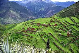
Calca District
Calca District is one of eight districts of the province Calca in Peru.[1]
Calca
Khallka | |
|---|---|
 | |
| Country | |
| Region | Cusco |
| Province | Calca |
| Capital | Calca |
| Government | |
| • Mayor | Ciriaco Condori Cruz |
| Area | |
| • Total | 311.01 km2 (120.08 sq mi) |
| Elevation | 2,928 m (9,606 ft) |
| Population | |
| • Total | 18,491 |
| • Density | 59/km2 (150/sq mi) |
| Time zone | UTC-5 (PET) |
| UBIGEO | 080401 |
Geography
Some of the highest mountains of the Urupampa mountain range, Ch'iqun, Q'irayuq, Sawasiray and Siriwani, lie in the northwestern part of the Calca District. Other mountains of the district are listed below:[2]
- Anqasmarka
- Asul Urqu
- Aya Urqu
- Chhullunkunayuq
- Ch'akiqucha
- Hatun Punta
- Huch'uy Raqha Kay
- Kancha Kancha Q'asa
- Kuntur Wachana
- Llamayuq Q'asa
- Maki Makiyuq
- Mullu Urqu
- Pachakutiq
- Pintasqa Wayq'u
- Pitusiray
- Puka Q'asa
- Pukaqucha
- Pukyupata
- Puma Kallanka
- Qusqu Qhawarina
- Qusqu Qhawarina (Calca)
- Sapan Sach'ayuq
- Silla Q'asa
- Suntur
- Wallata Wachana
- Wamanchuqi
- Yana Qaqa
- Yana Urqu
See also
References
- (in Spanish) Instituto Nacional de Estadística e Informática. Banco de Información Distrital Archived April 23, 2008, at the Wayback Machine. Retrieved April 11, 2008.
- escale.minedu.gob.pe - UGEL map of the CAlca Province (Cusco Region)
This article is issued from Wikipedia. The text is licensed under Creative Commons - Attribution - Sharealike. Additional terms may apply for the media files.