Catchment Management Authority (Victoria)
The Catchment Management Authorities (CMAs) were established in Victoria under the Catchment and Land Protection Act 1994. Originally known as Catchment and Land Protection Boards, the CMAs were changed to their present name in 1997.

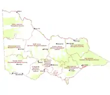
Catchment management authorities are unique because the area they govern corresponds to the naturally occurring drainage basins, enabling integrated catchment management.
Catchment Management Authorities
There are 10 CMAs covering the whole of Victoria:
- Corangamite
- East Gippsland
- Glenelg Hopkins
- Goulburn Broken
- Mallee
- North Central
- North East
- Port Phillip and Western Port
- West Gippsland
- Wimmera
Regional catchment strategies
Every 5 years the CMAs are required under Section 12 of the Act, to produce a regional catchment strategy, which is a statement of how the CMA plans to manage its region over the coming 5 years and is developed with the principles of integrated catchment management. It should cover the condition of the land and water, assess land degradation and prioritise areas for attention, set out a program of works to be undertaken and who will be undertaking the works, specify how the works and land and water condition will be monitored and provide for review of the strategy. The regional catchment strategy can also undertake to provide incentives to landholders, educational programs, research and other services.[1]
References
- Catchment and Land Protection Act 1994, s.12, page 49. Victorian Government, 2007.
External links
- Corangamite Catchment Management Authority website
- East Gippsland Catchment Management Authority website
- Glenelg Hopkins Catchment Management Authority website
- Goulburn Broken Catchment Management Authority website
- Mallee Catchment Management Authority website
- North Central Catchment Management Authority website
- North East Catchment Management Authority website
- Port Phillip and Western Port Catchment Management Authority website
- West Gippsland Catchment Management Authority website
- Wimmera Catchment Management Authority website
- Science week catchment factsheet