Chain of Rocks Lock
Chain of Rocks Lock and Dam, also known as Locks No. 27, is a lock situated at the southern end of Chouteau Island near St. Louis, Missouri on the Upper Mississippi River. Its associated dam is just downstream of the Chain of Rocks Bridge, and the lock is located over 3 miles (4.8 km) southeast on the Chain of Rocks canal. The canal and locks allow river traffic to bypass a portion of the river that is unnavigable in low water due to an anticlinal exposure of bedrock in the river—a "chain of rocks".
| Chain of Rocks Lock and Dam (Lock and Dam No. 27) | |
|---|---|
 Lock number 27. | |
| Official name | Locks No. 27 |
| Location | Madison / Granite City, Illinois, USA |
| Opening date | 1953 |
| Operator(s) | |
| Dam and spillways | |
| Impounds | Upper Mississippi River |

The 8.4-mile (13.5 km) canal, 1,200-foot (370 m) main lock, and 600-foot (180 m) auxiliary lock were built in the late 1940s and early 1950s to allow a by-pass of the Chain of Rocks lying in the main channel of the Mississippi River. This stretch of river in low water seasons was treacherous for commercial tow boats and barges, often requiring them to wait several days for the river to rise. The dam for lock 27 is atypical for the Mississippi, being a weir made of tons of rock laid in the Mississippi to create a small pool elevation upstream from the Chain of Rocks. The drop at Locks 27 can vary from a few feet to over a ten-foot drop depending on the river stage.

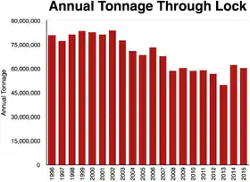
The Chain of Rocks Lock is operated by the St. Louis District of the U.S. Army Corps of Engineers. Locks No. 27 are the southernmost locks on the Mississippi River and they are the only Locks south of the confluence of the Mississippi River and Missouri River. As such, the Locks move more cargo than any other navigation structure on the Mississippi River.
September 2012 shutdown
An accident caused the lock to be shut down on September 15, 2012.[1] Over four dozen towboats, and over four hundred barges, were stranded when the lock was shut down. A large, rock-filled steel cell—used to help align barges prior to transiting the lock—split causing the channel to be blocked with rock. The cause of the incident was attributed to exceptionally low water levels.[2] The steel cell has armored sections, to protect it from impacts and abrasion from the heavy barges. But the water had fallen so low that barges were impacting an unarmored portion of the shaft.
References
- "Missouri: Damaged Lock Snarls Barge Traffic on Mississippi River". The New York Times. September 19, 2012. p. 21. Archived from the original on September 20, 2012.
Workers closed Lock 27 just north of St. Louis after discovering that a protection cell—a vertical, rock-filled steel cylinder against which barges rub to help align them for proper entry into the lock—had split open, spilling tons of rock into the channel and obstructing passage.
- Suhr, Jim (September 19, 2012). "Barge Traffic Halted near Mississippi River Lock". ABC News. Archived from the original on September 20, 2012. Retrieved September 20, 2012.
That damage was on an unarmored section of the protection cell that the barges don't typically make contact with because that portion often is 15 to 20 feet under water. But that part of the structure stands exposed because the river's level has been lowered dramatically by the nation's worst drought in decades, officials said.
External links
- Chain of Rocks Lock and Dam - U.S. Army Corps of Engineers
- Historic American Engineering Record (HAER) No. IL-33, "Upper Mississippi River 9-Foot Channel Project, Lock & Dam 27, Granite City, Madison County, IL"

| List of locks and dams of the Upper Mississippi River | ||
|---|---|---|
| Upstream: Melvin Price Locks and Dam |
Downstream: no further locks and dams | |
