Charlemagne, Quebec
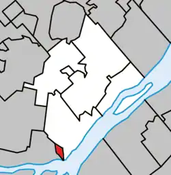
Charlemagne (pronounced [ʃaʁ.lə.maɲ]) is an off-island suburb of Montreal, Quebec, Canada. It is located on the north shore of the Rivière des Prairies, 24 kilometres (15 mi) northeast of Montreal's downtown core. As of 2011, the population was 5,853.
Charlemagne | |
|---|---|
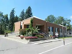
 Town hall of Charlemagne | |
 Location within L'Assomption RCM | |
 Charlemagne Location in central Quebec | |
| Coordinates: 45°43′N 73°29′W[1] | |
| Country | |
| Province | |
| Region | Lanaudière |
| RCM | L'Assomption |
| Constituted | November 13, 1906 |
| Government | |
| • Mayor | Normand Grenier |
| • Federal riding | Repentigny |
| • Prov. riding | L'Assomption |
| Area | |
| • Total | 2.30 km2 (0.89 sq mi) |
| • Land | 2.16 km2 (0.83 sq mi) |
| Population | |
| • Total | 5,853 |
| • Density | 2,704.0/km2 (7,003/sq mi) |
| • Pop 2006–2011 | |
| • Dwellings | 2,863 |
| Time zone | UTC−5 (EST) |
| • Summer (DST) | UTC−4 (EDT) |
| Postal code(s) | J5Z |
| Area code(s) | 450 and 579 |
| Highways | |
| Website | www |
It is the birthplace of singer Celine Dion.[4] The town council named one of its main streets after her[5] without the recognition of a Quebec commission.[6] Additionally, the town erected a sculpture on Dion's behalf.[6] Charlemagne is also the birthplace of politician Camille Laurin.
Demographics
Population
| Canada census – Charlemagne, Quebec community profile | |||
|---|---|---|---|
| 2011 | 2006 | ||
| Population: | 5,853 (+4.6% from 2006) | 5,594 (-1.2% from 2001) | |
| Land area: | 2.16 km2 (0.83 sq mi) | 2.16 km2 (0.83 sq mi) | |
| Population density: | 2,704.0/km2 (7,003/sq mi) | 2,584.5/km2 (6,694/sq mi) | |
| Median age: | 47.4 (M: 45.8, F: 48.8) | 43.7 (M: 42.3, F: 44.8) | |
| Total private dwellings: | 2,863 | 2,614 | |
| Median household income: | $48,351 | $44,731 | |
| References: 2011[7] 2006[8] earlier[9] | |||
|
|
|
Language
| Canada Census Mother Tongue - Charlemagne, Quebec[10] | ||||||||||||||||||
|---|---|---|---|---|---|---|---|---|---|---|---|---|---|---|---|---|---|---|
| Census | Total | French |
English |
French & English |
Other | |||||||||||||
| Year | Responses | Count | Trend | Pop % | Count | Trend | Pop % | Count | Trend | Pop % | Count | Trend | Pop % | |||||
2011 |
5,835 |
5,535 | 94.86% | 90 | 1.54% | 25 | 0.43% | 185 | 3.17% | |||||||||
2006 |
5,590 |
5,385 | 96.33% | 55 | 0.98% | 10 | 0.18% | 140 | 2.50% | |||||||||
2001 |
5,665 |
5,560 | 98.15% | 65 | 1.15% | 0 | 0.00% | 40 | 0.71% | |||||||||
1996 |
5,700 |
5,590 | n/a | 98.07% | 60 | n/a | 1.05% | 0 | n/a | 0.00% | 50 | n/a | 0.88% | |||||
Education
Sir Wilfrid Laurier School Board operates Anglophone public schools:
- Franklin Hill Elementary School in Repentigny[11]
- Rosemere High School in Rosemere[12]
See also
References
- Reference number 12423 of the Commission de toponymie du Québec (in French)
- Geographic code 60005 in the official Répertoire des municipalités (in French)
- Statistics Canada 2011 Census - Charlemagne census profile
- Céline Dion receives honorary doctorate in Quebec City CBC News Retrieved 2011-05-11
- toponymie.gouv.qc.ca
- Céline Dion's name goes on - a street CBC News Retrieved 2011-05-11
- "2011 Community Profiles". 2011 Canadian Census. Statistics Canada. July 5, 2013. Retrieved 2014-05-24.
- "2006 Community Profiles". 2006 Canadian Census. Statistics Canada. March 30, 2011. Retrieved 2014-05-24.
- "2001 Community Profiles". 2001 Canadian Census. Statistics Canada. February 17, 2012.
- Statistics Canada: 1996, 2001, 2006, 2011 census
- "FRANKLIN HILL ELEMENTARY ZONE." Sir Wilfrid Laurier School Board. Retrieved on September 17, 2017.
- "Rosemere High School Zone." Sir Wilfrid Laurier School Board. Retrieved on December 8, 2014.
This article is issued from Wikipedia. The text is licensed under Creative Commons - Attribution - Sharealike. Additional terms may apply for the media files.