Chester, West Virginia
Chester is a city in Hancock County, West Virginia, United States, along the Ohio River. Chester is the northernmost incorporated city in both West Virginia and the Southern United States as defined by the Census Bureau. The population was 2,585 at the 2010 census. It is part of the Weirton-Steubenville, WV-OH Metropolitan Statistical Area.
Chester, West Virginia | |
|---|---|
| City of Chester | |
 | |
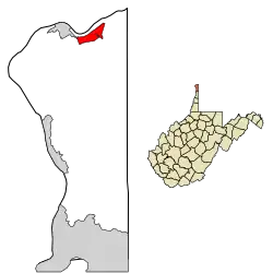
 Location of Chester in Hancock County, West Virginia. | |
| Coordinates: 40°36′46″N 80°33′46″W | |
| Country | United States |
| State | West Virginia |
| County | Hancock |
| Government | |
| • Mayor | Ken Morris |
| Area | |
| • Total | 1.00 sq mi (2.59 km2) |
| • Land | 1.00 sq mi (2.59 km2) |
| • Water | 0.00 sq mi (0.00 km2) |
| Elevation | 705 ft (215 m) |
| Population | |
| • Total | 2,585 |
| • Estimate (2019)[3] | 2,369 |
| • Density | 2,371.37/sq mi (915.53/km2) |
| Time zone | UTC-5 (Eastern (EST)) |
| • Summer (DST) | UTC-4 (EDT) |
| ZIP code | 26034 |
| Area code(s) | 304 |
| FIPS code | 54-15076[4] |
| GNIS feature ID | 1537260[5] |
| Website | City website |
Chester is home to the World's Largest Teapot.
History

Chester was established in 1896, but not incorporated until 1907. The city is named after J. Chester McDonald, one of the city's original planners.
Geography
Chester is located at 40°36′46″N 80°33′46″W (40.612792, -80.562771).[6] At the outbreak of hostilities of the American Civil War in April 1861, this location was part of Virginia and was the northernmost point in any slave state. Chester remains the northernmost point in the Southern United States, as defined by the United States Census Bureau, yet is located at the same latitude as parts of New York City (e.g., Staten Island).
The following highways pass through Chester:
According to the United States Census Bureau, the city has a total area of 1.00 square mile (2.59 km2), all of it land.[7]
Demographics
| Historical population | |||
|---|---|---|---|
| Census | Pop. | %± | |
| 1910 | 3,184 | — | |
| 1920 | 3,283 | 3.1% | |
| 1930 | 3,701 | 12.7% | |
| 1940 | 3,805 | 2.8% | |
| 1950 | 3,758 | −1.2% | |
| 1960 | 3,787 | 0.8% | |
| 1970 | 3,614 | −4.6% | |
| 1980 | 3,297 | −8.8% | |
| 1990 | 2,905 | −11.9% | |
| 2000 | 2,592 | −10.8% | |
| 2010 | 2,585 | −0.3% | |
| 2019 (est.) | 2,369 | [3] | −8.4% |
| U.S. Decennial Census[8] 2012 Estimate[9] | |||

2010 census
As of the census[2] of 2010, there were 2,585 people, 1,209 households, and 696 families living in the city. The population density was 2,585.0 inhabitants per square mile (998.1/km2). There were 1,381 housing units at an average density of 1,381.0 per square mile (533.2/km2). The racial makeup of the city was 98.0% White, 0.4% African American, 0.3% Asian, 0.6% from other races, and 0.6% from two or more races. Hispanic or Latino of any race were 1.4% of the population.
There were 1,209 households, of which 26.5% had children under the age of 18 living with them, 40.4% were married couples living together, 12.1% had a female householder with no husband present, 5.0% had a male householder with no wife present, and 42.4% were non-families. 38.3% of all households were made up of individuals, and 19.1% had someone living alone who was 65 years of age or older. The average household size was 2.14 and the average family size was 2.81.
The median age in the city was 43.2 years. 21.9% of residents were under the age of 18; 6.2% were between the ages of 18 and 24; 23.9% were from 25 to 44; 27.7% were from 45 to 64; and 20.2% were 65 years of age or older. The gender makeup of the city was 46.7% male and 53.3% female.
2000 census
As of the census[4] of 2000, there were 2,592 people, 1,160 households, and 725 families living in the city. The population density was 2,705.1 people per square mile (1,042.5/km2). There were 1,289 housing units at an average density of 1,345.2 per square mile (518.4/km2). The racial makeup of the city was 98.77% White, 0.15% African American, 0.23% Asian, 0.31% from other races, and 0.54% from two or more races. Hispanic or Latino of any race were 1.12% of the population.
There were 1,160 households, out of which 25.8% had children under the age of 18 living with them, 46.4% were married couples living together, 11.5% had a female householder with no husband present, and 37.5% were non-families. 33.8% of all households were made up of individuals, and 16.8% had someone living alone who was 65 years of age or older. The average household size was 2.23 and the average family size was 2.85.
In the city, the population was spread out, with 22.0% under the age of 18, 8.0% from 18 to 24, 27.2% from 25 to 44, 23.1% from 45 to 64, and 19.8% who were 65 years of age or older. The median age was 40 years. For every 100 females, there were 88.0 males. For every 100 females age 18 and over, there were 87.0 males.
The median income for a household in the city was $28,550, and the median income for a family was $37,672. Males had a median income of $30,625 versus $18,724 for females. The per capita income for the city was $17,137. About 8.1% of families and 10.8% of the population were below the poverty line, including 11.3% of those under age 18 and 11.6% of those age 65 or over.
Notable people
- Herb Coleman - football player
- Daniel Johnston - artist, singer and songwriter
- Win Mercer - Major League Baseball player[10]
- Scott Paulsen - radio personality, former host of The DVE Morning Show and columnist
References
- "2019 U.S. Gazetteer Files". United States Census Bureau. Retrieved August 7, 2020.
- "U.S. Census website". United States Census Bureau. Retrieved 2013-01-24.
- "Population and Housing Unit Estimates". United States Census Bureau. May 24, 2020. Retrieved May 27, 2020.
- "U.S. Census website". United States Census Bureau. Retrieved 2008-01-31.
- "US Board on Geographic Names". United States Geological Survey. 2007-10-25. Retrieved 2008-01-31.
- "US Gazetteer files: 2010, 2000, and 1990". United States Census Bureau. 2011-02-12. Retrieved 2011-04-23.
- "US Gazetteer files 2010". United States Census Bureau. Archived from the original on 2012-01-25. Retrieved 2013-01-24.
- United States Census Bureau. "Census of Population and Housing". Retrieved 17 Feb 2015.
- "Population Estimates". United States Census Bureau. Archived from the original on 2013-06-11. Retrieved 2013-06-26.
- Reichler, Joseph L., ed. (1979) [1969]. The Baseball Encyclopedia (4th ed.). New York: Macmillan Publishing. ISBN 0-02-578970-8.

