Chewton Keynsham
Chewton Keynsham (grid reference ST652664) is a hamlet on the River Chew in the Chew Valley, Somerset. It is 7 miles from Bristol, 7 miles from Bath, and 2 miles (3.2 km) south of the centre of the town of Keynsham.
| Chewton Keynsham | |
|---|---|
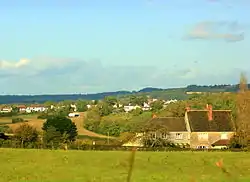
 North from Fairy Hill, looking toward Chewton Keynsham and Keynsham | |
_Mission_Church_-_geograph.org.uk_-_67713.jpg.webp) Mission Church | |
 Chewton Keynsham Location within Somerset | |
| Population | approx. 100 |
| OS grid reference | ST652664 |
| Civil parish | |
| Unitary authority | |
| Ceremonial county | |
| Region | |
| Country | England |
| Sovereign state | United Kingdom |
| Post town | BRISTOL |
| Postcode district | BS40 |
| Dialling code | 01761 |
| Police | Avon and Somerset |
| Fire | Avon |
| Ambulance | South Western |
| UK Parliament | |
The place lies on the Monarch's Way long distance footpath.
Government and politics
Chewton Keynsham is part of the Farmborough Ward which is represented by one councillor on the Bath and North East Somerset Unitary Authority which has wider responsibilities for services such as education, refuse, tourism etc. The village is a part of the North East Somerset constituency. Prior to Brexit in 2020, it was part of the South West England constituency of the European Parliament.
Demographics
According to the 2011 Census, the E00072685 output area (which extended from Queens Charlton to Burnett, both with higher populations), had 286 residents of which 40 were children, living in 117 households. Of these 242 described their health as 'good' or 'very good', 32 adults had no qualifications; 1 person was unemployed, whereas 77 were economically inactive, which includes carers, 18 students and 44 retirees.[1]
Geography
The settlement is linear with outlying farms on the valley slopes and has an 18th-century bridge crossing the River Chew, which follows the course of the village street north-south. Farmland occupies most of the mixed clay and calciferous hillsides and semi-plateaus above, interspersed by small areas of ancient woodland and many hedgerows.[2][3]
Chewton Place
Chewton Place is a Grade II listed building . It is a large detached private house [4] It was built about 1762 for the Popham family and further extended c. 1786. It was extensively remodelled in 1860–70 and restored in 1968 after flood damage . The house was fully renovated from 2013 - 2017 . The building contains a number of historic features including a fine plaster ceiling from the late 19th Century and a gothic staircase.[5] A folly tower, known locally as the Owl Tower, was built in the grounds in the late 18th century — a tall tapering square obelisk of coursed limestone finished with a pyramidal cap. It has pointed-arched openings, east and west, giving a walk-through passage at the base and diagonal buttresses. The carved owl on a keystone probably gives the folly, which is Grade II-recognised, its name.[6] The gardens were laid out in the 18th Century and include a Ha-Ha and riverside walks. The bridge adjacent to the entrance Lodge is also listed.[7] The Lodge itself is an 18th Century building but remodelled in the Gothic style at the same time as the main house was altered in 1860s.[8]
See also
- Chewton Mendip, upriver, also in Somerset.
- Chewton, Victoria, Australia
References
- Output areas: quick statistics (2011 census) Retrieved 2017-04-29.
- Historic England. "Chewton Pack Horse Bridge at ST 654 664 (1384604)". National Heritage List for England. Retrieved 15 May 2016.
- Hinchliffe, Ernest (1994). Guide to the Packhorse Bridges of England. Cicerone. pp. 136–137. ISBN 978-1852841430.
- Historic England. "Chewton Place (1255451)". National Heritage List for England. Retrieved 14 January 2014.
- Historic England. "Chewton Place (1255451)". National Heritage List for England. Retrieved 20 June 2015.
- Historic England. "Folly approx. 15m to west of Chewton Place (1255453)". National Heritage List for England. Retrieved 14 January 2014.
- Historic England. "Bridge and attached wall and fence across the River Chew at Chewton Place (1255452)". National Heritage List for England. Retrieved 9 December 2017.
- Manco, Jean. "The History of The Manor Queen Charlton, Somerset" (PDF). Bath and North East Somerset. Archived from the original (PDF) on 14 December 2017. Retrieved 13 December 2017.
- ^ "Neighbourhood Statistics LSOA Bath and North East Somerset 016B Farmborough". Office for National Statistics 2001 Census. Retrieved 1 May 2006.
External links
| Wikimedia Commons has media related to Chewton Keynsham. |