Chino Valley, Arizona
Chino Valley is a town in Yavapai County, Arizona, United States. According to the 2010 census, the population of the town is 10,817.[2]
Chino Valley, Arizona | |
|---|---|
.jpg.webp) Chino Valley welcome sign | |
 Location of Chino Valley in Yavapai County, Arizona | |
 Chino Valley, Arizona Location in Arizona  Chino Valley, Arizona Chino Valley, Arizona (the United States) | |
| Coordinates: 34°45′30″N 112°26′59″W | |
| Country | United States |
| State | Arizona |
| County | Yavapai |
| Government | |
| • Mayor | Darryl Croft |
| Area | |
| • Total | 63.43 sq mi (164.29 km2) |
| • Land | 63.37 sq mi (164.13 km2) |
| • Water | 0.06 sq mi (0.16 km2) |
| Elevation | 4,707 ft (1,435 m) |
| Population | |
| • Total | 10,817 |
| • Estimate (2019)[3] | 12,375 |
| • Density | 195.28/sq mi (75.40/km2) |
| Time zone | UTC-7 (MST) |
| ZIP code | 86323 |
| Area code(s) | 928 |
| FIPS code | 04-12840 |
| GNIS feature ID | 27601 |
| Website | Town of Chino Valley |
Geography
Chino Valley is located at 34°45′30″N 112°26′59″W (34.758381, -112.449758).[4] The town is located adjacent the southeast terminus of Chino Valley, about 9 miles (14 km) north at Paulden. The smaller north-trending Little Chino Valley lies just east of the townsite.
According to the United States Census Bureau, the town has a total area of 63.4 square miles (164 km2), all of it land.
History
Chino Valley is the site of the first Territorial Capital of Arizona. The capital moved to Prescott, 15 miles (24 km) away, in 1864. U.S. Army Cavalry Lt. Amiel W. Whipple, while traveling through the area in 1854, gave the community its name. "Chino" is the Spanish name for the abundant curly grama grass growing in the area.
In 1895, a narrow gauge branch of the United Verde and Pacific Railroad to Jerome, joining the Santa Fe, Prescott, and Phoenix Railway, was completed, and Jerome Junction was established. In 1923, the activities of Jerome Junction were absorbed by Chino Valley.[5]
The town of Chino Valley was incorporated in 1970.
The town is in north-central Arizona, on state Highway 89, 15 miles (24 km) north of Prescott and 35 miles (56 km) south of Ash Fork, which is on Interstate 40. Chino Valley is at an elevation of about 4,750 feet (1,450 m).
Demographics
| Historical population | |||
|---|---|---|---|
| Census | Pop. | %± | |
| 1970 | 803 | — | |
| 1980 | 2,858 | 255.9% | |
| 1990 | 4,837 | 69.2% | |
| 2000 | 7,835 | 62.0% | |
| 2010 | 10,817 | 38.1% | |
| 2019 (est.) | 12,375 | [3] | 14.4% |
| U.S. Decennial Census[6] | |||
As of the census of 2000, there were 7,835 people, 3,030 households, and 2,172 families residing in the town. The population density was 421.6 people per square mile (162.8/km2). There were 3,256 housing units at an average density of 175.2 per square mile (67.7/km2). The racial makeup of the town was 94.1% White, 0.2% Black or African American, 0.9% Native American, 0.2% Asian, 0.1% Pacific Islander, 2.6% from other races, and 1.9% from two or more races. 9.8% of the population were Hispanic or Latino of any race.
There were 3,030 households, out of which 32.5% had children under the age of 18 living with them, 57.3% were married couples living together, 10.3% had a female householder with no husband present, and 28.3% were non-families. 23.0% of all households were made up of individuals, and 11.1% had someone living alone who was 65 years of age or older. The average household size was 2.58 and the average family size was 3.01.
In the town, the population was spread out, with 26.5% under the age of 18, 7.1% from 18 to 24, 25.0% from 25 to 44, 25.1% from 45 to 64, and 16.2% who were 65 years of age or older. The median age was 40 years. For every 100 females, there were 96.4 males. For every 100 females age 18 and over, there were 91.5 males.
The median income for a household in the town was $32,289, and the median income for a family was $35,013. Males had a median income of $27,160 versus $21,667 for females. The per capita income for the town was $15,555. About 12.6% of families and 15.5% of the population were below the poverty line, including 20.2% of those under age 18 and 13.5% of those age 65 or over.
Climate
| Climate data for Chino Valley, Arizona | |||||||||||||
|---|---|---|---|---|---|---|---|---|---|---|---|---|---|
| Month | Jan | Feb | Mar | Apr | May | Jun | Jul | Aug | Sep | Oct | Nov | Dec | Year |
| Average high °F (°C) | 52.3 (11.3) |
56.3 (13.5) |
62.1 (16.7) |
69.9 (21.1) |
78.5 (25.8) |
88.6 (31.4) |
92.4 (33.6) |
89.5 (31.9) |
85.5 (29.7) |
75.0 (23.9) |
63.2 (17.3) |
53.7 (12.1) |
72.3 (22.4) |
| Average low °F (°C) | 21.5 (−5.8) |
24.1 (−4.4) |
28.3 (−2.1) |
34.4 (1.3) |
41.7 (5.4) |
49.8 (9.9) |
59.0 (15.0) |
57.2 (14.0) |
49.1 (9.5) |
38.0 (3.3) |
27.3 (−2.6) |
21.3 (−5.9) |
37.6 (3.1) |
| Average precipitation inches (mm) | 0.95 (24) |
0.93 (24) |
0.92 (23) |
0.56 (14) |
0.34 (8.6) |
0.28 (7.1) |
1.81 (46) |
2.01 (51) |
1.27 (32) |
0.81 (21) |
0.64 (16) |
0.97 (25) |
11.50 (292) |
| Average snowfall inches (cm) | 2.2 (5.6) |
1.4 (3.6) |
1.3 (3.3) |
0.2 (0.51) |
0.0 (0.0) |
0.0 (0.0) |
0.0 (0.0) |
0.0 (0.0) |
0.0 (0.0) |
0.0 (0.0) |
0.5 (1.3) |
1.5 (3.8) |
7.1 (18) |
Education
The Chino Valley Unified School District presently operates four school facilities in the Town of Chino Valley. Territorial Early Education Center (Pre-K through Second Grade) and Del Rio Elementary (Third through Fifth Grades) students.
Heritage Middle School educates sixth through eighth graders in the district. Two County Teachers of the Year and Two Channel 3 Silver Apple Teacher award winners are on the HMS faculty.
Chino Valley High School partners with Yavapai College Campus for Agribusiness, Science & Technology, located in Chino Valley, where seniors may jointly enroll in CVHS and Yavapai for advanced study. The school's Aquaculture & Biotech Lab, Greenhouse and Livestock Facilities support the FFA program. CVHS houses five computer lab environments for students plus programs in music and art, and an FBLA program, along with the full component of extracurricular activities and sports programs.
The district operates under the supervision of a five-member governing board and one district superintendent. The district presently employs 7 administrators and 6 directors on a full-time basis, 158 certified teachers and 190 full- and part-time classified employees.
Chino Valley has two charter schools that operate in the town. Mingus Springs is a kindergarten–8th grade school that services over 180 students. Excel Education Centers is a 6th–12th grade school that services over 50 students.
Chino Valley also has a campus of Yavapai College.
Government
| Title | Name |
|---|---|
| Mayor | Darryl Croft |
| Vice Mayor | Mike R. Best |
| Council Member | Corey Mendoza |
| Council Member | Lon Turner |
| Council Member | Anne Lane |
| Council Member | Jack Miller |
Gallery
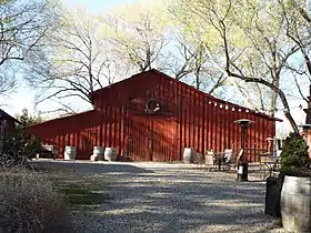
 1917 Granite Creek Vineyards Barn
 Abandoned 1919 Latter-day Saints chapel
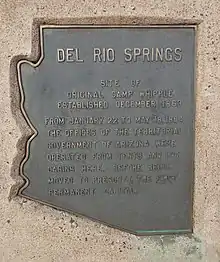
Del Rio Springs
There is a Historical Marker in Chino Valley which has the following inscription:[7]
Site of original Camp Whipple established December 1863
From January 22 to May 18, 1864 the offices of the Territorial Government of Arizona were operated from tents and log cabins here, before being moved to Prescott the first permanent capital.

References
- "2019 U.S. Gazetteer Files". United States Census Bureau. Retrieved June 30, 2020.
- "U.S. Census website". United States Census Bureau. Retrieved 2014-08-05.
- "Population and Housing Unit Estimates". United States Census Bureau. May 24, 2020. Retrieved May 27, 2020.
- "US Gazetteer files: 2010, 2000, and 1990". United States Census Bureau. 2011-02-12. Retrieved 2011-04-23.
- Massey, Peter; Wilson, Jeanne (2006). Backcountry Adventures Arizona: The Ultimate Guide to the Arizona Backcountry for Anyone With a Sport Utility Vehicle. Adler Publishing Co. pp. 65, 261. ISBN 1-930193-28-9. Retrieved July 31, 2010.
- "Census of Population and Housing". Census.gov. Retrieved June 4, 2016.
- https://www.historicalmarkerproject.com/markers/HMMBP_del-rio-springs_Chino-Valley-AZ.html
External links
- Chino Valley, AZ
- Chino Valley, Arizona Detailed Profile
- Chino Valley Unified School District
- Chino Valley Chamber of Commerce
- Chino Valley Review
- Prescott eNews – Original Local News Website
- Chino Valley Historical Society
| Wikimedia Commons has media related to Chino Valley, Arizona. |
