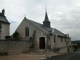
Coulanges, Loir-et-Cher
Coulanges is a former commune in the Loir-et-Cher department of central France. On 1 January 2017, it was merged into the new commune Valloire-sur-Cisse.[2]
Coulanges | |
|---|---|
Part of Valloire-sur-Cisse | |
 | |
 Coat of arms | |
Location of Coulanges 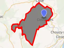
| |
 Coulanges  Coulanges | |
| Coordinates: 47°32′38″N 1°13′26″E | |
| Country | France |
| Region | Centre-Val de Loire |
| Department | Loir-et-Cher |
| Arrondissement | Blois |
| Canton | Onzain |
| Commune | Valloire-sur-Cisse |
| Area 1 | 8.35 km2 (3.22 sq mi) |
| Population (2017)[1] | 311 |
| • Density | 37/km2 (96/sq mi) |
| Time zone | UTC+01:00 (CET) |
| • Summer (DST) | UTC+02:00 (CEST) |
| Postal code | 41150 |
| Elevation | 67–116 m (220–381 ft) (avg. 105 m or 344 ft) |
| 1 French Land Register data, which excludes lakes, ponds, glaciers > 1 km2 (0.386 sq mi or 247 acres) and river estuaries. | |
Population
| Year | Pop. | ±% |
|---|---|---|
| 1793 | 342 | — |
| 1806 | 318 | −7.0% |
| 1821 | 329 | +3.5% |
| 1831 | 317 | −3.6% |
| 1841 | 349 | +10.1% |
| 1851 | 326 | −6.6% |
| 1861 | 367 | +12.6% |
| 1872 | 351 | −4.4% |
| 1881 | 318 | −9.4% |
| 1891 | 359 | +12.9% |
| 1901 | 340 | −5.3% |
| 1911 | 283 | −16.8% |
| 1921 | 232 | −18.0% |
| 1931 | 232 | +0.0% |
| 1946 | 206 | −11.2% |
| 1954 | 194 | −5.8% |
| 1962 | 219 | +12.9% |
| 1968 | 216 | −1.4% |
| 1975 | 274 | +26.9% |
| 1982 | 301 | +9.9% |
| 1990 | 271 | −10.0% |
| 1999 | 312 | +15.1% |
| 2008 | 307 | −1.6% |
| 2013 | 316 | +2.9% |
References
- Téléchargement du fichier d'ensemble des populations légales en 2017, INSEE
- Arrêté préfectoral 4 June 2016 (in French)
| Wikimedia Commons has media related to Coulanges (Loir-et-Cher). |
| Authority control |
|---|
This article is issued from Wikipedia. The text is licensed under Creative Commons - Attribution - Sharealike. Additional terms may apply for the media files.