Creswell, Derbyshire
Creswell is a former mining village located in the Bolsover district of Derbyshire, England. At the 2011 Census population details were included in the civil parish of Elmton-with-Creswell. Today it is best known for Creswell Crags and its model village. In September 1950 Creswell Colliery was the scene of one of the worst post-nationalisation mining disasters. Elmton Common is an area of allotments for the township of Creswell.[1]
| Creswell | |
|---|---|
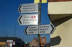
 Signs seen from the corner of Wollen Close and Mansfield Road (2006) | |
 Creswell Location within Derbyshire | |
| Population | 1,735 |
| District | |
| Shire county | |
| Region | |
| Country | England |
| Sovereign state | United Kingdom |
| Post town | WORKSOP |
| Postcode district | S80 |
| Dialling code | 01909 |
| Police | Derbyshire |
| Fire | Derbyshire |
| Ambulance | East Midlands |
| UK Parliament | |
Local Government services are provided by Elmton-with-Creswell Parish Council, Bolsover District Council and Derbyshire County Council.
History
Whilst Elmton is mentioned in the Domesday Book, Creswell remained a nearby collection of farming houses until the construction of a turnpike road along the present A616 brought added importance. The arrival of the coal mining industry in the last decade of the 19th century had a dramatic effect on the area and Creswell became the larger community. The name Creswell arose because the Colliery company needed an address to send the tackle to in order to build the colliery. The closest farm was Creswell's farm. As there was no town , all the machinery and boxes arrived with the delivery drop off of "Creswell's" written on them . So the name Creswell stuck . Only Whitwell, Elmton & Thorp (Salvin) were the original Saxon towns. Before Creswell Village was built , Creswell Crags was known locally as Whitwell Crags. This may be what was referred to when King Alfred's grandson, King Edmund conquered the 5 Boroughs from the Viking Earls, reaching as far as Dore & Hwitan Wylles Geat' (the Whitwell Gap).
20th century
Creswell expanded throughout the 20th century after a lease was obtained from the Duke of Portland in 1894 for the top hard seam of coal in the area and Creswell Colliery came into being. The Bolsover Colliery Company owned the pit until it was nationalised in 1947. Creswell Colliery was regarded as one of the most efficient pits in the East Midlands coalfield. The colliery was known for its sporting and social activities and Creswell Colliery Band was for a long time one of the country’s leading brass bands and had been broadcast several times on BBC Radio.
Creswell Model Village was built in 1895 to house the coal mining families. Expansion of housing continued throughout the 20th century. Creswell is in Derbyshire but close to the borders of Nottinghamshire and Yorkshire. Creswell has a Worksop postal address with a South Yorkshire postcode. Derbyshire can be used in the postal address. Creswell Colliery was in the North Nottinghamshire coalfield but miners holidayed at the Derbyshire Miners' Holiday Camp.
Creswell Colliery mining disaster, 1950
On 26 September 1950 during the early hours of the morning a damaged conveyor belt caught in a machine at the colliery and caused the motor to overheat and catch fire trapping 80 men beyond the flames. They all perished as a result of the fumes and smoke. As word of the disaster spread, Creswell residents rushed to the pithead to offer assistance. One miner, who had broken his back several months before, went down the stricken pit, with a back brace on, to rescue his fellow workers.
Serious errors prevented the fire from being extinguished quickly and only 57 bodies were initially recovered and 23 remained underground for the best part of a year. The fire was finally put out after the entire colliery had been sealed to starve it of oxygen and it did not reopen until Easter 1951 when most of the remaining bodies were recovered. The last three victims were recovered on 11 August 1951 nearly eleven months after the fire.[2]
The enquiry[2] presided over by the Minister of Fuel and Power Geoffrey Lloyd, described a number of factors involved in the high death rate, including telephones being too far from the face, repair work being done on the "paddy" (the underground train used to convey the men to and from the lift shaft), inadequate air shafts and low water pressure in the fire hoses.[3]
Amenities
Creswell had two railway stations. Creswell & Welbeck (known locally as Top Station) was opened by the LD&ECR in 1897[4][5] and closed in September 1939.[6] Elmton and Creswell (known as Bottom Station) was on the Midland Railway line running between Worksop and Nottingham. The line and station closed in October 1964, leaving the village without a rail service. From 1993 the line was reopened northwards from Nottingham in stages under the name Robin Hood Line. The final section from Mansfield Woodhouse to Worksop was reopened in 1998, with the old Bottom Station reopening as plain "Creswell".
The local landscape had been very beautiful but during the 20th century it was scarred by a century of mining with the black, spoil tips of unwanted debris from miles underground, with the air-born pollution from the pit chimneys always belching out smoke, scarred by poor architecture and housing.
Beyond the village, the landscape has two very unusual features: Creswell Crags and Markland Grips. Both are dolomitic limestone gorges but the former is much more important as the caves that it hosts have been found to contain not only prehistoric artefacts but also cave art. During World War II children used to play in the caves at the Crags. In the woods behind the Crags there is a quarry. The woods were a great place for sweet chestnuts. Markland Grips was popular for fishing, hazelnuts and blackberries.

By the mid 20th century Creswell supported facilities not to be found in other villages, such as a cinema and some baths. The original cinema was in King Street, but in the 1930s it burned down and was replaced. The new cinema on Elmton Road was a stylish art deco structure, built by the Rogers family and called the Regors. Like many others it became a bingo hall in the late 1960s. The baths were built in 1924. As a council facility they included not only a swimming pool but also slipper baths for the many homes that did not have their own bathrooms at that date.
The village had one main Church of England parish church, St Mary Magdalene's Church, Creswell, and both a Methodist and Baptist chapel. A third chapel had been closed down and was then used as part of the Infant School. A Roman Catholic church was built in the late 1950s.
Creswell Colliery closed in the early 1990s, after the UK miners' strike (1984-1985). Creswell like many other communities throughout the UK had to look for a new direction. A significant drop in population took place.
The Creswell Social Centre (previously called The Drill Hall) has always been the hub of the village; hosting parties and weddings along with sports and entertainment such as wrestling and boxing, both of which have given the Creswell people an event to watch and in many cases the competitors have been from Creswell and the surrounding areas such as Whitwell and Worksop. The Social Centre was managed by local residents Ray and Margaret Adlam from 1980 - 1989. The centre has also had something for the ladies with male strippers being the feature of a 'Ladies Only' night in August 2009.
References
Notes
- "MSS - Portland (London) Nottinghamshire and Derbyshire Estate Papers, Sales 3, University of Nottingham". Archived from the original on 12 January 2014. Retrieved 3 March 2014.
- http://www.dmm.org.uk/ukreport/8574-03.htm Creswell Colliery Disaster report
- Graham McEwan,"Crypts, Caves and Catacombs - Subterranea of Derbyshire and Nottinghamshire", Sigma Leisure (February 1994),
- Dow 1965, p. 161.
- Cupit & Taylor 1984, p. 23.
- Butt 1995.
Sources
- Butt, R. V. J. (1995). The Directory of Railway Stations: details every public and private passenger station, halt, platform and stopping place, past and present (1st ed.). Sparkford: Patrick Stephens Ltd. ISBN 978-1-85260-508-7. OCLC 60251199.
- Cupit, J.; Taylor, W. (1984) [1966]. The Lancashire, Derbyshire & East Coast Railway. Oakwood Library of Railway History (2nd ed.). Headington: Oakwood Press. ISBN 0-85361-302-8. OL19.
- Dow, George (1965). Great Central, Volume Three: Fay Sets the Pace, 1900-1922. Shepperton: Ian Allan. ISBN 0-7110-0263-0.
External links
| Wikimedia Commons has media related to Creswell, Derbyshire. |