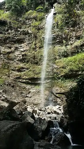
El Guache National Park
The El Guache National Park[1] (Spanish: Parque nacional El Guache)[2] Is a protected area with the status of national park[3] in Venezuela,[4] located at the beginning of the Andes mountain range, comprising mountainous parts of the Lara and Portuguesa states, and the birth of the Guache, Ospino, Toco, Morador and Are rivers. 2 In its adjacencies is the mighty waterfall San Miguel. It has an area of 12,200 ha traditionally measured and 15,960 Ha. Its temperature is between 19 °C. and 26 °C. Precipitation varies between 1800 and 2000 mm annually.
| El Guache National Park Parque nacional El Guache | |
|---|---|
IUCN category II (national park) | |
 | |
.jpg.webp) Location | |
| Location | |
| Coordinates | 9°34′N 69°33′W |
| Area | 122 km2 (47 sq mi) |
| Established | June 5, 1992 |
It was decreed National Park on June 5, 1992, in order to protect the high basins of the Guache, Ospino, Bocoy, Toco and Are rivers.
References
- "Parque nacional El Guache". inparques.gob.ve. Retrieved 2017-03-11.
- A, Nidia L. Cuello (1999-01-01). Parque Nacional Guaramacal (in Spanish). UNELLEZ. ISBN 9789803790035.
- Memoria y cuenta (in Spanish). Ministerio del Ambiente y de los Recursos Naturales Renovables. 1994-01-01.
- Guía ecoturística de Venezuela (in Spanish). Miro Popić Editor C.A. 1995-01-01.
This article is issued from Wikipedia. The text is licensed under Creative Commons - Attribution - Sharealike. Additional terms may apply for the media files.