Embarrass, Minnesota
Embarrass is an unincorporated community in Embarrass Township, Saint Louis County, Minnesota, United States.
Embarrass | |
|---|---|
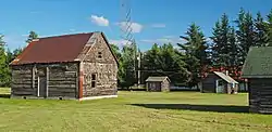
 The Nelimark Homestead Museum in Embarrass | |
| Motto(s): "The Cold Spot" | |
 Embarrass Location of the community of Embarrass within Embarrass Township, Saint Louis County  Embarrass Embarrass (the United States) | |
| Coordinates: 47°39′33″N 92°11′53″W | |
| Country | United States |
| State | Minnesota |
| County | Saint Louis |
| Township | Embarrass Township |
| Elevation | 1,424 ft (434 m) |
| Population | |
| • Total | 30 |
| Time zone | UTC−6 (Central (CST)) |
| • Summer (DST) | UTC−5 (CDT) |
| ZIP codes | 55732 |
| Area code(s) | 218 |
| GNIS feature ID | 661211[1] |
The community is located on the Mesabi Iron Range. With an average annual temperature of 34.4 °F (1.3 °C), Embarrass is notable as the coldest place in Minnesota.
Geography and climate
The community of Embarrass is located 22 miles (35.4 km) northeast of the city of Virginia; and 27 miles (43.5 km) southwest of Ely. Embarrass is 12 miles (19.3 km) south of Tower; and 86 miles (138.4 km) north of Duluth. Nearby places include Tower, Aurora, Hoyt Lakes, Biwabik, and Babbitt.
The center of Embarrass is generally considered near the intersection of Saint Louis County Roads 21, 362 (Waisanen Road), and 615 (Salo Road); located in the southeast portion of Embarrass Township (population 607). The Embarrass River flows through the community. The Pike River is also nearby.
State Highway 135 (MN 135), Saint Louis County Highway 21 (CR 21), and County Road 26 (CR 26) are three of the main routes in the Embarrass area.
Embarrass has a humid continental climate (Köppen Dfb), bordering very closely on a subarctic climate (Dfc), with short, warm summers and long, bitterly cold winters. Summer nights remain cool despite the warm days. With an average annual temperature of 34.4 °F (1.3 °C),[2] Embarrass is the coldest place in Minnesota. In January 2005, Embarrass had a near-record low temperature of −54 °F (−48 °C). The unofficial low temperature is −64 °F (−53 °C), which was reached in February 1996.25th anniversary of the coldest temperature recorded in Minnesota The thermometer that measured this temperature was verified for accuracy by Taylor Environmental Instruments, but as it was not recorded at a National Weather Service Cooperative Site, it will remain unofficial. The current record low temperature for Minnesota −60 °F (−51 °C) was recorded outside of the nearby town of Tower on February 2, 1996 by the NWS Cooperative Observer located there.
According to the NOAA, there has been at least a trace of snowfall recorded every month of the year.[3]
The average first and last dates for a freeze are August 31st and June 20th, giving Embarrass a short average growing season of only 72 days.
| Climate data for Embarrass, Minnesota (1981–2010) | |||||||||||||
|---|---|---|---|---|---|---|---|---|---|---|---|---|---|
| Month | Jan | Feb | Mar | Apr | May | Jun | Jul | Aug | Sep | Oct | Nov | Dec | Year |
| Record high °F (°C) | 44 (7) |
55 (13) |
74 (23) |
78 (26) |
87 (31) |
96 (36) |
94 (34) |
92 (33) |
90 (32) |
84 (29) |
66 (19) |
46 (8) |
96 (36) |
| Average high °F (°C) | 15.3 (−9.3) |
21.7 (−5.7) |
34.0 (1.1) |
50.0 (10.0) |
63.7 (17.6) |
70.9 (21.6) |
75.8 (24.3) |
73.4 (23.0) |
63.8 (17.7) |
48.5 (9.2) |
32.8 (0.4) |
18.7 (−7.4) |
47.4 (8.6) |
| Daily mean °F (°C) | 2.1 (−16.6) |
7.7 (−13.5) |
21.0 (−6.1) |
36.1 (2.3) |
48.1 (8.9) |
56.7 (13.7) |
61.5 (16.4) |
59.6 (15.3) |
50.8 (10.4) |
37.7 (3.2) |
23.3 (−4.8) |
7.8 (−13.4) |
34.4 (1.3) |
| Average low °F (°C) | −11 (−24) |
−6.2 (−21.2) |
7.9 (−13.4) |
22.1 (−5.5) |
32.9 (0.5) |
42.5 (5.8) |
47.2 (8.4) |
45.8 (7.7) |
37.8 (3.2) |
26.8 (−2.9) |
13.8 (−10.1) |
−3.1 (−19.5) |
21.4 (−5.9) |
| Record low °F (°C) | −57 (−49) |
−56 (−49) |
−44 (−42) |
−14 (−26) |
8 (−13) |
23 (−5) |
27 (−3) |
23 (−5) |
17 (−8) |
1 (−17) |
−25 (−32) |
−45 (−43) |
−57 (−49) |
| Average precipitation inches (mm) | 0.95 (24) |
0.69 (18) |
1.28 (33) |
2.15 (55) |
3.27 (83) |
4.17 (106) |
4.01 (102) |
3.94 (100) |
3.93 (100) |
2.69 (68) |
1.60 (41) |
1.08 (27) |
29.76 (756) |
| Average snowfall inches (cm) | 14.1 (36) |
8.1 (21) |
8.1 (21) |
3.7 (9.4) |
0.1 (0.25) |
0 (0) |
0 (0) |
0 (0) |
trace | 1.1 (2.8) |
7.2 (18) |
8.9 (23) |
43.0 (109) |
| Source: NOAA[2] | |||||||||||||
Name origins
The name Embarrass was derived from the French word embarras, based on its meaning of "to hinder with obstacles or difficulties". It was given this name by the French fur traders who were some of the first Europeans to visit the area, and who found the narrow, shallow river very difficult to navigate, and named the river "Embarras".
See also
References
- "Embarrass, Minnesota". Geographic Names Information System. United States Geological Survey.
- "NOWData - NOAA Online Weather Data". National Oceanic and Atmospheric Administration. Retrieved May 29, 2016.
- Team, National Weather Service Corporate Image Web. "National Weather Service Climate". w2.weather.gov. Retrieved 2020-04-14.
- Rand McNally Road Atlas – 2007 edition – Minnesota entry
- Official State of Minnesota Highway Map – 2011/2012 edition
- Mn/DOT map of Saint Louis County – Sheet 4 – 2011 edition
External links
- Embarrass.org – Community website
