Emu Vale, Queensland
Emu Vale is a rural town and locality in the Southern Downs Region, Queensland, Australia.[2][3] In the 2016 census, Emu Vale had a population of 185 people.[1]
| Emu Vale Queensland | |||||||||||||||
|---|---|---|---|---|---|---|---|---|---|---|---|---|---|---|---|
 Maize and Wheat Crops, Emu Val, circa 1899 | |||||||||||||||
 Emu Vale | |||||||||||||||
| Coordinates | 28.2288°S 152.2488°E | ||||||||||||||
| Population | 185 (2016 census)[1] | ||||||||||||||
| • Density | 1.131/km2 (2.931/sq mi) | ||||||||||||||
| Postcode(s) | 4371 | ||||||||||||||
| Area | 163.5 km2 (63.1 sq mi) | ||||||||||||||
| Time zone | AEST (UTC+10:00) | ||||||||||||||
| Location | |||||||||||||||
| LGA(s) | Southern Downs Region | ||||||||||||||
| State electorate(s) | Southern Downs | ||||||||||||||
| Federal Division(s) | Maranoa | ||||||||||||||
| |||||||||||||||
History
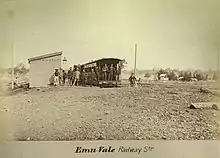
The town takes its name from the Emu Vale railway station on the Killarney railway line, which is believed to be named after an early pastoral run.[2]
Emu Vale Provisional School opened on 2 February 1876. It became Emu Vale State School on 20 January 1879. It closed in 2003.[4] The school was located on the triangle of land bounded by Yangan Killarney Road, Swift Road and Emu Creek (28.2245°S 152.2453°E).[5]
Land in Emu Vale was open for selection on 17 April 1877; 75 square miles (190 km2) were available.[6]

The first section of the Killarney railway line from Warwick was 24 kilometres (15 mi) long and terminated at Emu Vale. The contract to build the first section was given to John Garget on 22 November 1881, but progress was delayed when the Queensland Railway Department was unable to provide the locomotives and wagons need to carry the construction materials. The first section to Emu Vale railway station opened on 2 June 1884. It was officially opened with a train from Warwick decorated with flags and greenery with several hundred passengers on board. The second section of the railway from Emu Vale to Killarney railway station was also built by Garget and completed on 22 August 1885.[7]
Rocky Mountain Provisional School opened on 1919 and closed circa 1920.[4]
The Emu Vale Memorial Hall was officially opened on Saturday 28 May 1954 by Sir Raymond Huish.[8][9]
In the 2016 census, Emu Vale had a population of 185 people.[1]
Community groups
The Emu Vale branch of the Queensland Country Women's Association meets at the Emu Vale Memorial Hall at 559 Yangan Killarney Road (28.2297°S 152.2474°E).[10]
References
- Australian Bureau of Statistics (27 June 2017). "Emu Vale (SSC)". 2016 Census QuickStats. Retrieved 20 October 2018.

- "Emu Vale – town in Southern Downs Region (entry 11733)". Queensland Place Names. Queensland Government. Retrieved 13 June 2020.
- "Emu Vale – locality in Southern Downs Region (entry 45925)". Queensland Place Names. Queensland Government. Retrieved 13 June 2020.
- Queensland Family History Society (2010), Queensland schools past and present (Version 1.01 ed.), Queensland Family History Society, ISBN 978-1-921171-26-0
- "Town map of Emu Vale". Queensland Government. 1990. Archived from the original on 26 December 2017. Retrieved 19 April 2019.
- "Proclamations under the New Land Acts". The Brisbane Courier. Queensland, Australia. 2 March 1877. p. 3. Retrieved 19 February 2020 – via Trove.
- Kerr, John (1990). Triumph of narrow gauge : a history of Queensland Railways. Boolarong Publications. p. 59-60. ISBN 978-0-86439-102-5.
- "Advertising". Warwick Daily News (10, 836). Queensland, Australia. 6 May 1954. p. 2. Retrieved 1 September 2020 – via National Library of Australia.
- "War Memorial Hall for Emu Vale". Warwick Daily News (10, 449). Queensland, Australia. 4 February 1953. p. 2. Retrieved 1 September 2020 – via National Library of Australia.
- "Emu Vale Branch". Queensland Country Women's Association. Retrieved 1 September 2020.