Ficulle
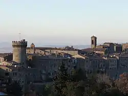
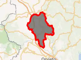
Ficulle is a comune (municipality) in the Province of Terni in the Italian region Umbria, located about 40 km southwest of Perugia and about 60 km northwest of Terni.
Ficulle | |
|---|---|
| Comune di Ficulle | |
 | |
Location of Ficulle 
| |
 Ficulle Location of Ficulle in Italy  Ficulle Ficulle (Umbria) | |
| Coordinates: 42°50′N 12°4′E | |
| Country | Italy |
| Region | Umbria |
| Province | Terni (TR) |
| Government | |
| • Mayor | Gianluigi Maravalle |
| Area | |
| • Total | 64.62 km2 (24.95 sq mi) |
| Elevation | 437 m (1,434 ft) |
| Population (31 July 2017)[2] | |
| • Total | 1,654 |
| • Density | 26/km2 (66/sq mi) |
| Demonym(s) | Ficullesi |
| Time zone | UTC+1 (CET) |
| • Summer (DST) | UTC+2 (CEST) |
| Postal code | 05016 |
| Dialing code | 0763 |
| Website | Official website |
Ficulle borders the following municipalities: Allerona, Fabro, Montegabbione, Orvieto, Parrano, San Venanzo.
History
The origins of the town and the castle date back to the 11th century even though it is supposed to have been born in the beginning as a trading station of the Roman Empire. Because of the excellent territorial position, in the Middle Ages Ficulle was contended by two noble families: Monaldeschi and Filippeschi, both from Orvieto. It suffered their struggles until 1416 AD, when the town passed under control of the Papal States.
Main sights
- Walls and Rocca (fortress)
- Castello della Sala, founded in 1350
- Medieval borough
- Church of Santa Maria Vecchia (early 13th century)
- Abbey of S. Niccolò al Monte Orvietano
- Sanctuary of Madonna della Maestà
References
- "Superficie di Comuni Province e Regioni italiane al 9 ottobre 2011". Istat. Retrieved 16 March 2019.
- All demographics and other statistics: Italian statistical institute Istat.
This article is issued from Wikipedia. The text is licensed under Creative Commons - Attribution - Sharealike. Additional terms may apply for the media files.