Flushing–Main Street station (LIRR)
Flushing–Main Street is a station on the Long Island Rail Road's Port Washington Branch in the Flushing neighborhood of Queens, New York City. The station is part of the LIRR's CityTicket, and is in Zone 3. The station is located at Main Street and 41st Avenue, off Kissena Boulevard and is 9.5 miles (15.3 km) from Penn Station in Midtown Manhattan and 10.4 miles (16.73 km) southwest of Port Washington.
Flushing – Main Street | |||||||||||||||
|---|---|---|---|---|---|---|---|---|---|---|---|---|---|---|---|
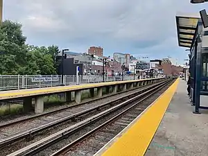
 View from eastbound Platform "B" to Port Washington | |||||||||||||||
| Location | Main Street and 41st Avenue Flushing, Queens, New York | ||||||||||||||
| Coordinates | 40.757989°N 73.831086°W | ||||||||||||||
| Owned by | Long Island Rail Road | ||||||||||||||
| Platforms | 2 side platforms | ||||||||||||||
| Tracks | 2 | ||||||||||||||
| Connections | New York City Subway: | ||||||||||||||
| Construction | |||||||||||||||
| Parking | Yes (metered) | ||||||||||||||
| Disabled access | Yes | ||||||||||||||
| Other information | |||||||||||||||
| Fare zone | 3 | ||||||||||||||
| History | |||||||||||||||
| Opened | June 26, 1854 (NY&F)[1] | ||||||||||||||
| Rebuilt | 1865, 1870, 1913, 1958, 2018 | ||||||||||||||
| Electrified | October 22, 1912 750 V (DC) third rail | ||||||||||||||
| Previous names | Flushing (1853–1870) | ||||||||||||||
| Passengers | |||||||||||||||
| 2012—2014 | 2,224[2] | ||||||||||||||
| Rank | 50 of 125 | ||||||||||||||
| Services | |||||||||||||||
| |||||||||||||||
History

The Flushing–Main Street station was originally built in December 1853 as the Flushing station by the New York and Flushing Railroad, but not opened until June 26, 1854. Flushing served as the terminus of the NY&F until October 30, 1864 when a subsidiary known as the North Shore Railroad extended it to Great Neck, and it was burned in order to prepare for a second station that was built between January and February 1865. In 1868, the station and the rest of the line were acquired by the Flushing and North Side Railroad, which razed the second station in 1870 and built a third station between October and November 1870. The station was renamed after both Flushing and Main Street, in order to distinguish itself from the former Flushing Bridge Street station that ran along the F&NS's Whitestone Branch, which was abandoned by the LIRR in 1932.
During the mid-1870s, the station and the rest of the line merged with the Central Railroad of Long Island to form the Flushing, North Shore and Central Railroad, and then became part of the Port Washington Branch of the Long Island Rail Road, which also used the station as the eastern terminus of the White Line between 1873 and 1876. Shortly after the line was electrified on October 22, 1912, the station was abandoned on November 11, 1912, as part of an effort by the Long Island Rail Road to bring the Port Washington Branch above and below street level depending on the location.
In Flushing, the station was elevated along with the rest of the tracks on October 4, 1913. Until that point, the line used to run at grade and went through a tunnel under a girls' school just east of where the Main Street overpass stands today.[3] The tunnel and the school were torn down to build the overpass and the open cut through which the line now runs. In 1958, the elevated track level building was razed and replaced with a street level ticket office. Sheltered platforms exist on both sides of the tracks in the former station's place, and the sidewalks beneath the bridge serve local businesses.
Accessibility
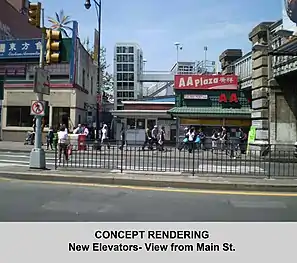
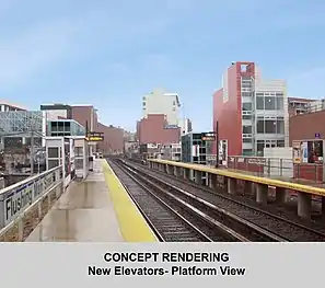
The Metropolitan Transportation Authority renovated the station in the 2010s, bringing it into compliance with the 1990 Americans With Disabilities Act. According to a description of the $24.6 million project, one elevator was built from each platform to street level, and various components of the station were renovated. A one-story commercial building on the west side of Main Street was demolished and replaced by a station house with an elevator, which provided more direct access to the westbound platform.[4]
On October 28, 2013, the MTA held a public hearing on the proposed acquisition of private property at 40-36 Main Street in Flushing for the purpose of adding an elevator intended for the rebuilt station. By June 2015, design had been completed and one of the two parcels of private property, a food stall, had been acquired. The MTA expected to complete the eminent domain acquisition of Ou-Jang Supermarket's 40-36 Main Street property by summer 2015; the supermarket objected to the amount MTA offered, $974,592. On January 6, 2016, filings in Queens County Superior Court showed that MTA and the supermarket reached a settlement of $2,236,600, of which $1.9 million was the cash purchase price and the remainder represented rent to be paid by MTA on behalf of the supermarket at its new location.[5] The MTA began in July 2016 and planned to complete the project by the 4th quarter of 2017.[6] In December 2015, the MTA had put the project out for competitive bidding with a proposal due date of December 9, 2015.[7]
On July 22, 2016, the ticket office was closed as part of the two-year renovation project along with the staircase to the eastbound platform with a temporary staircase and platform extension providing access.[8][9] The current staircase to the city-bound platform will be closed for renovation upon the opening of a new staircase and elevator.[10] Completion of the project was set for early 2018,[11] though as of summer 2018, the elevators had been completed.[10]
Station layout
The station has two high-level side platforms, each 10 cars long.
| P Platform level |
Platform A, side platform | |
| Track 1 | ← Port Washington Branch toward Penn Station (Mets–Willets Point or Woodside) | |
| Track 2 | Port Washington Branch toward Great Neck or Port Washington (Murray Hill) → | |
| Platform B, side platform | ||
| G | Ground level | Exit/entrance and buses |
Bus service
In addition to connecting with the nearby subway station of the same name, Flushing–Main Street serves as a major bus-to-rail interchange in Queens, with over 20 bus routes running through or terminating in the area as of 2015.
| Route | Operator | Stop location | North/West Terminal | South/East Terminal | via | notes |
|---|---|---|---|---|---|---|
| MTA-operated bus routes | ||||||
Q12 |
NYCT | Roosevelt Avenue (near Lippmann Plaza) | Little Neck | Sanford Avenue, Northern Boulevard | ||
Q13 |
39th Avenue (near Lippmann Plaza) | Fort Totten | Northern Boulevard, Bell Boulevard | |||
Q15
Q15A |
Roosevelt Avenue (near Lippmann Plaza) | Beechhurst | 41st Avenue, 150th Street | |||
Q16 |
39th Avenue (near Lippmann Plaza) | Fort Totten | Bayside Avenue | |||
| Main Street | Jamaica–Merrick Boulevard | Kissena Boulevard, Horace Harding Expressway, 188th Street, Hillside Avenue | ||||
Q19 |
MTA Bus | Roosevelt Avenue (west of Main Street) | Astoria | Northern Boulevard, Astoria Boulevard | ||
| NYCT | Main Street | College Point | Jamaica–Merrick Boulevard | 20th Avenue (Q20A), 14th Avenue (Q20B), Main Street, Archer Avenue | ||
| MTA Bus | College Point | Jamaica–LIRR Station | 127th Street, Kissena Boulevard, Parsons Boulevard | |||
| NYCT | Roosevelt Avenue (near Lippmann Plaza) | Auburndale | Parsons Boulevard, 46th Avenue, Hollis Court Boulevard | Rush-hours only | ||
| Main Street | Queens Village or Cambria Heights | Kissena Boulevard, 46th Avenue, 48th Avenue, Springfield Boulevard | ||||
Q28 |
39th Avenue (near Lippmann Plaza) | Bay Terrace Shopping Center | Northern Boulevard, Crocheron Avenue, 32nd Avenue, Corporal Kennedy Street | |||
| MTA Bus | Main Street | Whitestone | Jamaica–LIRR Station | Union Street, Kissena Boulevard, Parsons Boulevard | ||
| NYCT | Bronx Zoo–West Farms Square | Jamaica–Merrick Boulevard | Cross Bronx Expressway, Parsons Boulevard, Union Street, Main Street, Archer Avenue | Converted into Q44 Select Bus Service on November 29, 2015. | ||
Q48 |
Roosevelt Avenue (west of Main Street) | LaGuardia Airport | Roosevelt Avenue, 108th Street, Ditmars Boulevard | |||
| MTA Bus | Co-op City, Bronx | Whitestone Expressway, Hutchinson River Parkway, Bruckner Boulevard, Co-op City Boulevard | Limited-stop Service | |||
| NYCT | 41st Road | Ridgewood Terminal | College Point Boulevard, Corona Avenue, Grand Avenue, Fresh Pond Road | |||
| MTA Bus | Main Street | College Point | Jamaica–LIRR Station | College Point Boulevard, 45th Avenue, 164th Street | ||
Q66 |
Roosevelt Avenue (west of Main Street) | Long Island City–Queens Plaza | Northern Boulevard, 35th Avenue, 21st Street | |||
| Nassau Inter-County Express (NICE)-operated bus routes | ||||||
n20G |
NICE Bus | Roosevelt Avenue (near Lippmann Plaza) | Great Neck LIRR Station | Northern Boulevard | Transfer at Great Neck for n20H to Hicksville | |
Gallery
- Flushing-Main Street (LIRR)
_-_March_2019.jpg.webp) Entrance of Flushing Main Street station (LIRR) - March 2019
Entrance of Flushing Main Street station (LIRR) - March 2019_station.jpg.webp) Help Point at Flushing Main Street (LIRR) station
Help Point at Flushing Main Street (LIRR) station Rendering for planned elevator at Flushing station (street view)
 Rendering for planned elevator at Flushing station (platform view)
 A Port Washington Branch train enters the station
References
- Vincent F. Seyfried, The Long Island Rail Road: A Comprehensive History, Part Two: The Flushing, North Shore & Central Railroad, © 1963
- "2012-2014 LIRR Origin and Destination Report : Volume I: Travel Behavior Among All LIRR Passengers" (PDF). Metropolitan Transportation Authority. August 23, 2016. PDF pp. 15, 198. Archived (PDF) from the original on July 17, 2019. Retrieved March 29, 2020.
Data collection took place after the pretest determinations, starting in September 2012 and concluding in May 2014. .... 2012-2014 LIRR O[rigin and ]D[estination] COUNTS: WEEKDAY East/West Total By Station in Numerical Order ... Flushing Main Street
- October 12, 1913 image of Water Tank & Tunnel @ Flushing Station by Vincent Seyfried and Asadorian (TrainsAreFun.com)
- "Public Hearing: LIRR Flushing Main Street Station Improvement Project". Metropolitan Transportation Authority. Archived from the original on April 30, 2014. Retrieved October 31, 2013.
- Toure, Madina (February 12, 2016). "MTA settles Flushing LIRR eminent domain case". Times Ledger.
- Toure, Madina (June 24, 2015). "Flushing LIRR station project to be completed by 2017: MTA". Times Ledger.
- "Current Solicitations". MTA LIRR. Metropolitan Transportation Authority. June 29, 2016. Retrieved September 17, 2016.
- "MTA LIRR – Flushing Main Street". lirr42.mta.info. Retrieved September 16, 2016.
- "Flushing-Main Street Station Ticket Office Closure Effective Friday". web.mta.info. Retrieved September 16, 2016.
- "MTA LIRR - Flushing Main Street Station Improvement Project". web.mta.info. Retrieved September 16, 2016.
- Monteverdi, Suzanne (September 15, 2017). "Elevators under construction at Flushing-Main Street LIRR station". Queens Courier. Retrieved December 13, 2017.
External links
| Wikimedia Commons has media related to: |
- Unofficial LIRR Website Photos.
- Main Street entrance from Google Maps Street View
- Platforms from Google Maps Street View (2016)
- East end of platforms from Google Maps Street View (2018)
- Middle of platforms from Google Maps Street View (2018)
- West end of platforms from Google Maps Street View (2018)
- Alleyway Entrance from Google Maps Street View (2018)

