General Madariaga Partido
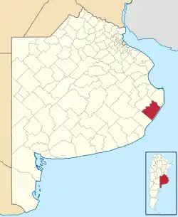
General Madariaga Partido (Spanish pronunciation: [xeneˈɾal maðaˈɾjaɣa]) is a partido located on the Atlantic coast of Buenos Aires Province in Argentina.
General Juan Madariaga
Partido de General Juan Madariaga | |
|---|---|
 Flag  Coat of arms | |
 location of General Madariaga Partido in Buenos Aires Province | |
| Coordinates: 37°00′07″S 57°08′10″W | |
| Country | Argentina |
| Established | 8 December 1907 |
| Seat | General Juan Madariaga |
| Government | |
| • Mayor | Esteban Santoro (UCR) |
| Area | |
| • Total | 286.3 km2 (110.5 sq mi) |
| Population | |
| • Total | 18,286 |
| • Density | 64/km2 (170/sq mi) |
| Demonym(s) | madariaguense |
| Postal Code | B7163 |
| IFAM | |
| Area Code | 02267 |
| Patron saint | Sagrado Corazón de Jesús |
| Website | www |
This provincial subdivision had a population of about 18,000 inhabitants in an area of 286.3 km2 (111 sq mi).
Economy
The economy of General Madariaga Partido is concentrated around agricultural production, although in the summer vacation season (December-February) tourism offers a valuable addition to the economy.
This article is issued from Wikipedia. The text is licensed under Creative Commons - Attribution - Sharealike. Additional terms may apply for the media files.