Godmanstone
Godmanstone (or Godmanston[2]) is a village and civil parish in the county of Dorset in southern England, situated approximately 4 miles (6.4 km) north of the county town Dorchester. Its name means Godman's Farm[2] and it is sited by the River Cerne amongst chalk hills of the Dorset Downs. Dorset County Council's latest (2013) estimate of the parish population is 130.[1] In the 2011 census the population of Godmanstone parish combined with the small adjoining parish of Nether Cerne was 156.[3]
| Godmanstone | |
|---|---|
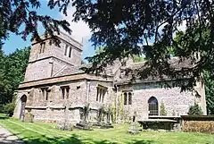
 Parish church of the Holy Trinity, Godmanstone | |
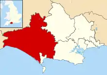
 Godmanstone Location within Dorset | |
| Population | 130 [1] |
| OS grid reference | SY667972 |
| Unitary authority | |
| Shire county | |
| Region | |
| Country | England |
| Sovereign state | United Kingdom |
| Post town | Dorchester |
| Postcode district | DT2 |
| Police | Dorset |
| Fire | Dorset and Wiltshire |
| Ambulance | South Western |
| UK Parliament | |
Godmanstone used to have a pub—The Smiths Arms—which claimed to be the smallest in Britain. The story attached to the claim was that the original licence was granted by King Charles II when he requested that the village smith serve him a glass of porter. The smith refused because he had no licence, so Charles granted him one on the spot and was served his drink. The licence only applied to the smithy; adjacent living quarters, subsequently used by drinkers, were larger.[4] The business has since closed.
The parish church is partly Norman, chiefly perpendicular, with a tower; and was recently repaired.
References
- "Parish Population Data". Dorset County Council. 20 January 2015. Retrieved 28 February 2015.
- Roland Gant (1980). Dorset Villages. Robert Hale Ltd. p. 149. ISBN 0 7091 8135 3.
- "Area: Godmanstone (Parish), Key Figures for 2011 Census: Key Statistics". Neighbourhood Statistics. Office for National Statistics. Retrieved 29 January 2014.
- Ralph Wightman (1983). Portrait of Dorset (4 ed.). Robert Hale Ltd. pp. 102–3. ISBN 0 7090 0844 9.
