Guna Yala
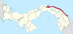
Guna Yala, formerly known as San Blas, is a comarca indígena (indigenous province) in northeast Panama (Official Gazette of Panama). Guna Yala is home to the indigenous people known as the Gunas. Its capital is El Porvenir. It is bounded on the north by the Caribbean Sea, on the south by the Darién Province and Emberá-Wounaan, on the east by Colombia, and on the west by the province of Colón.
Guna Yala | |
|---|---|
 Flag | |
 | |
| Coordinates: 9°33′N 78°58′W | |
| Country | |
| Capital | El Porvenir |
| Area | |
| • Total | 2,358.2 km2 (910.5 sq mi) |
| Population (2010) | |
| • Total | 33,109[1] |
| Time zone | UTC-5 (ETZ) |
| ISO 3166 code | PA-KY |
| HDI (2017) | 0.580[2] medium |
Etymology
Guna Yala in Kuna means "Land Guna" or "Guna Mountain". The area was formerly known as San Blas, and later as Kuna Yala, but the name was changed in October 2011 to "Guna Yala" when the Government of Panama recognized the claim of the people that "Guna" was a closer representation of the name.
History
The area was the site of the conquistador stronghold of Acla, where Vasco Núñez de Balboa was tried and beheaded.
In the late 1690s, the Darien scheme in the Kingdom of Scotland attempted to create an overseas colony in the region, hoping to open an overland route between the Atlantic and Pacific oceans, almost two centuries prior to the opening of the Panama Canal. They founded the town of New Edinburgh on a bay they named the Bay of Caledonia (a few kilometres southeast of modern Ustupo), as the capital of a new colony to be named "Caledonia" after the Latin name for Scotland. A combination of poor planning, famine, tropical disease and collusion between the East India Company and the Kingdom of England to frustrate the scheme lead to the failure of the colony and the death of the majority of the colonists. The town finally surrendered to a siege and blockade of the port by forces of the Spanish Empire in March 1700, and the few survivors were evacuated. Of the 2,500 colonists who had left Scotland, barely a few hundred returned. This costly and high-profile failure caused the bankruptcy of the Scottish government and was a major contributory factor in weakening resistance to the loss of Scottish sovereignty to London through the Act of Union less than a decade later.
By the Colombian Act of June 4, 1870 Tulenega Shire was created, which also included the present territory of the Guna Yala district; this comprises some of the communities of the District of Wargandí such as Mordi, and Sogubdi Asnadi; the communities of the region of Madungandi including Tiuarsicuá, and Guna communities of Colombia, such as Tanela and Arquía. The land area of the Tulenega Shire stretched from the province of Colon to the Gulf of Urabá, Colombia. The head of regional government was generally a commissioner appointed by the central government.[3] The law also recognized the Guna as property owners of the Shire.
After separation of Panama in 1903, the Act of 1870 was ignored. The territory of the former region was divided de facto into two parts: the majority remained in the new Republic of Panama, while a small portion remained in Colombia.
The suspension of the region, the incursions of outsiders into Guna villages in search of gold, rubber, and sea turtles, banana concessions, and colonial police abuse caused great discontent among the natives and brought the February 25, 1925 Guna Revolution, led by Nele Kantule of the town of Ustupu and Ologintipipilele (Simral Colman) of Ailigandi. The armed Guna attacked the police on the islands and Ugupseni Tupile, as the police were accused of abuses and suppressing Guna customs in several communities. The Guna proclaimed the independent Republic of Tule, separating from the central government of Panama for a few days.
The subsequent peace treaty established the commitment of the Government of Panama to protecting the customs of the Guna. The Guna, in turn, accepted the development of a formal school system in the islands. The police brigade would be expelled from their territory and all prisoners released. The negotiations that ended the armed conflict constituted a first step towards establishing the autonomous status of the Guna and maintaining the culture that was being suppressed.
Based on Article 5 of the Constitution of 1904, which allows for special political divisions for reasons of administrative convenience or public service, legislation on indigenous territories in Panama established the Guna District of San Blas in 1938 including areas of the provinces of Panamá and Colón. Its boundaries and administration were finalized by Act No. 16 of 1953.
Currently, according to the ruling of the Supreme Court of 23 March 2001, the region has a different political and administrative organization, independent of the Districts and Villages. The counties are governed by special institutions themselves, and by resolution of Division of the Supreme Court, on 6 December 2000, an institution is the consent of indigenous peoples who wish to develop projects in their territories.
Governor Erick Martelo was removed from office in September 2020 after being found traveling in a car with 75 packages of illegal drugs.[4]
Government and politics
The governmental structure of Guna Yala is defined in Law 16 of 1953. The General Congress Guna is the highest political authority of Guna Yala. It consists of representatives of all communities in Guna Yala, and meets twice a year. Votes are taken by each sahila (elected leader) of the community.
Political subdivisions of Guna Yala
Guna Yala is politically subdivided into four corregimientos (districts), with a total of 51 comunidades (communities), most of which are located on islands of the San Blas Archipelago off the mainland coast. They are listed from east to west:
Corregimiento de Narganá
- Wichupwala
- Nalunega
- Gorbisgi
- Carti Mamidup
- Uargandup
- Ailidup
- Orosdup
- Mandi Ubgigandup
- Arridup
- Narasgandup Dummar or Big Orange
- Narasgandup bipy or Orange Girl
- Akwadup
- Carti Sugdupu
- Carti Mulatupu
- Carti Yandup
- Carti Tupile
- Mirya Ubgigandup or Soledad Miria
- Mormagedup or Machine Island
- Mamardup
- Urgandi
- Nusadup
- Uargandup or Sugar River
- Yandup or Narganá
- Agwanusadup or Corazón de Jesús (Heart of Jesus)
- Digir or Isla Tigre
- Niadup or Ticantiquí
- Maguebgandi
- Nabagandi
Corregimiento de Ailigandi
Corregimiento de Dubwala
Corregimiento de Puerto Obaldía
- Armila (mainland)
- Port Obaldía (mainland)
Geography
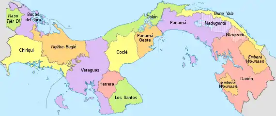
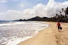
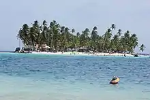
The Guna District of Yala has an area of 2.306 square kilometres (0.89 sq mi). It consists of a narrow strip of land of 373-kilometre (232 mi) long on the east coast of Caribbean Panama, bordering the province of Darién and Colombia. An archipelago of 365 islands is around the coast, of which 50 are inhabited.
By boat, going from the most southeastern point, Puerto Obaldia, to the most northwestern point, El Porvenir, is a bit more than 100 miles.
Economy
The economy of Guna Yala is mainly agriculture, fishing, tourism, and handicraft production.
Agriculture in Guna Yala is for subsistence purposes. Traditional products are bananas (now the Chinese banana), corn, and sugar cane. Coconuts are also produced as a source of income.
The fishery is artisanal, usually using wire (line) or networks. Most fishing is for sale. The seafood is especially intended for sale, for which planes come daily to the islands. Sold are lobster, crab, squid, and octopus.
The production of molas is the main activity of Guna women, and is for many families the principal source of income.
There are tourist facilities in Guna Yala. Most are small hotels for ecotourism. Most of them are in the field of Carti, but there are also several in the township of Ailigandi.
Another source of income is remittances from relatives working in the cities of Panama and Colon.
Customs and traditions
Among the most important traditions of the Guna people there are:
"Ico-inna" or Feast of the needle in lack of a more accurate translation, is the feast of puberty or what in the Western world is known as the party or wedding, where a young girl after her first menstrual period participates in a party. The pubescent female gets her septum pierced and a ring with coconut oil as an antiseptic is placed through it.
In childhood between 4 and 5 takes place the ceremony of "inna-suit" or baptism. It's performed in the first haircut, which is attended by all the people in the community. The female is assigned a name in the language Guna. This name is next to the name given in the country's official language.
The Night festival or "inna-mutiki" is a party where all the people get involved into the celebration of a wedding or a new marriage in the village or community. This festival usually lasts several days until the liquor stock garnered by the families is finished.
Demographics
The Guna District of Yala has a population of 31,557 inhabitants (2010), which shows a progressive decrease in the population.
Guna Revolution
The Guna Revolution refers to the events in 1925, in which the Guna Indians fought the ruling Panamanian authorities, who were attempting to force the Indians to adopt Hispanic culture by military action. During this revolution the Guna Yala territory seceded and operated as the short-lived Republic of Tule. Following mediation by the United States, the Guna re-united with Panama. The Gunas, with the support of the Panamanian government, created an autonomous territory called the Guna Yala district for the indigenous inhabitants which they would rule themselves.
Background
During the first twenty years of the independent country of Panama, the Kuna had serious differences with national governments, because they tried to eradicate their culture, their customs, and their disrespect, indigenous authorities wanted to strip the land apart and were outraged by the governors and the colonial police (a settler to a native, is a non-Indian). This is linked to an incident on April 20, 1921, which was staged in the Corazón de Jesús Narganá and Westernization movement for women, which was to change clothes, take away the gold ring of the nose, the plates high carat gold, beads, winks, and coin necklaces worn as ornaments. But a woman escaped and fled to Rio Narganá Sugar, from which it came. The police in retaliation imprisoned his children and his son, who was released to the outside to look.
That day at Sugar River had an indigenous congress and there it was decided not to let the woman go, so the sahila on behalf of the community sent a message saying that the police were not looking for it. The police did not heed the message that night and sent a commission to Rio Colonial Sugar two police officers and three Indians. When trying to stop some of the male relatives of women, began the battle and killed three residents of the town, two Indian policemen and others were injured with machete wildly as they fled in a canoe. The bodies of the policemen were left in the water, tied to a stick in the sand enlcavado until they came to collect their families.
The atmosphere remained tense until January 1925. Juan Demosthenes Arosemena was the governor of the province of Colon, and was concerned about the information he had supplied the mayor of San Blas, Andrés Mojica, on a course between the indigenous independence movement, so we decided to tell the Foreign Secretary Horacio F. Alfaro, to follow closely the actions of Americans Anne Coope, missionary, and explorer Richard Oglesby Marsh. Just Marsh was the promoter of independence. On his return to Panama in January 1925, he found a conflict between police and indigenous ready to explode, so he asked the U.S. military intervention in the Canal Zone, to exercise a protectorate, and wrote the Declaration of Independence and Tule people's human rights and Darién. Marsh was supported by the U.S. ambassador, who helped the Panamanian government establish a peace agreement that would guarantee human rights and political rights of Guna.
Revolution

.svg.png.webp)
The situation worsened until February 12, 1925, in a conference held in Ailigandi, where he met top leaders of 45 villages and tribes. The conference lasted 26 days, proclaiming the Republic of Tule, and fixing territorial limits. This uprising was under a flag was made by Waga Ebinkili (Mary Colman), granddaughter of Chief Simral Colman. It had a rectangular design with stripes. The center was yellow with the upper and lower stripes in red and with a figure of left facing swastika. On February 21, 10 days after the declaration of independence, in the midst of the Carnival, indigenous revolution broke out that lasted until 27 February, which was led by Nele Gantule and chief Colman. It is said that the insurgents were traveling in canoes from indigenous and Carti Ailigandi for the purpose of attacking the National Police headquarters in Playon Chico, Río Tigre, Tigantigí, Narganá, UGAP and elsewhere in the archipelago, and carried much of the police contingent. The toll was 27 dead.
On 4 March, with the presence of the American minister, John G. South, was signed the peace agreement with the Guna, who were promised a better deal, respect for their customs, not to impose the establishment of schools, and were assured the same protection and rights enjoyed by other citizens. The Guna, in turn, pledged to lay down their weapons, withdraw their declaration of independence, and abide by the laws of Panama.
See also
 Panama portal
- Mola (art form)
- San Blas Islands
Notes
- "Cuadro 11. Superficie, población y densidad de población en la República, según Provincia, Comarca indígena, Distrito y Corregimiento: Censos de 1990, 2000 y 2010". Instituto Nacional de Estadística y Censo, Contraloría General de la República de Panamá. Retrieved 11 November 2016.
- "Sub-national HDI - Area Database - Global Data Lab". hdi.globaldatalab.org. Retrieved 2018-09-13.
- "History". Guna Yala. Archived from the original on April 17, 2016. Retrieved April 11, 2016.
- "Panama governor stopped in car with 79 drug parcels". news.yahoo.com. BBC. September 15, 2020. Retrieved Sep 16, 2020.
References
- Panama in figures: Years 2000-2004, The Statistics and Census of the Comptroller General of the Republic
Further reading
- Baker, Christopher P. and Mingasson, Gilles. National Geographic Traveler: Panama. (2nd ed.) Washington, DC: National Geographic, 2011.
- Humphreys, Sara and Calvo, Raffa. The Rough Guide to Panama. London: Rough Guides, 2010.
- Lecumberry, Michel. San Blas: molas and Kuna traditions. (2nd ed., rev) [Panama]: Txango Publications, 2006.