Hòa Bình (city)
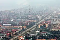
Hòa Bình (Vietnamese: [hʷâː ɓîŋ̟] (![]() listen)) is a city in Vietnam. It is the capital of Hòa Bình Province, and is located 76 kilometres from Hanoi and 5 kilometres from the Đà River.[1] The Battle of Hòa Bình was fought around the city from 1951–52 during the First Indochina War.
listen)) is a city in Vietnam. It is the capital of Hòa Bình Province, and is located 76 kilometres from Hanoi and 5 kilometres from the Đà River.[1] The Battle of Hòa Bình was fought around the city from 1951–52 during the First Indochina War.
Hòa Bình Dam, the largest hydroelectric dam in Vietnam, and also the largest in Southeast Asia,[2] is located near the city. It was built by means of finances and experts from the Soviet Union.
Hòa Bình
Thành phố Hòa Bình | |
|---|---|
| Hòa Bình City | |
 | |
| |
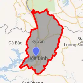
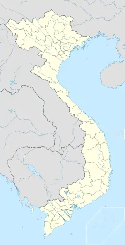 Hòa Bình Location of Hòa Bình in Vietnam | |
| Coordinates: 20°48′48″N 105°20′18″E | |
| Country | |
| Province | Hòa Bình |
| Area | |
| • Total | 348.65 km2 (134.61 sq mi) |
| Population | |
| • Total | 189,210 |
| Climate | Cwa |
Climate
| Climate data for Hòa Bình | |||||||||||||
|---|---|---|---|---|---|---|---|---|---|---|---|---|---|
| Month | Jan | Feb | Mar | Apr | May | Jun | Jul | Aug | Sep | Oct | Nov | Dec | Year |
| Record high °C (°F) | 34.1 (93.4) |
35.7 (96.3) |
38.5 (101.3) |
39.7 (103.5) |
41.2 (106.2) |
39.9 (103.8) |
39.3 (102.7) |
39.0 (102.2) |
36.7 (98.1) |
39.0 (102.2) |
35.2 (95.4) |
33.2 (91.8) |
41.2 (106.2) |
| Average high °C (°F) | 20.5 (68.9) |
21.4 (70.5) |
24.6 (76.3) |
29.1 (84.4) |
32.7 (90.9) |
33.6 (92.5) |
33.6 (92.5) |
32.8 (91.0) |
31.6 (88.9) |
29.0 (84.2) |
25.8 (78.4) |
22.6 (72.7) |
28.1 (82.6) |
| Daily mean °C (°F) | 16.5 (61.7) |
17.6 (63.7) |
20.7 (69.3) |
24.5 (76.1) |
27.3 (81.1) |
28.4 (83.1) |
28.5 (83.3) |
28.0 (82.4) |
26.8 (80.2) |
24.3 (75.7) |
20.9 (69.6) |
17.7 (63.9) |
23.4 (74.1) |
| Average low °C (°F) | 13.8 (56.8) |
15.2 (59.4) |
18.2 (64.8) |
21.6 (70.9) |
23.8 (74.8) |
25.1 (77.2) |
25.3 (77.5) |
25.1 (77.2) |
23.9 (75.0) |
21.2 (70.2) |
17.8 (64.0) |
14.6 (58.3) |
20.5 (68.9) |
| Record low °C (°F) | 1.9 (35.4) |
5.0 (41.0) |
7.2 (45.0) |
11.1 (52.0) |
16.7 (62.1) |
18.6 (65.5) |
19.6 (67.3) |
21.9 (71.4) |
16.1 (61.0) |
10.8 (51.4) |
5.1 (41.2) |
2.0 (35.6) |
1.9 (35.4) |
| Average precipitation mm (inches) | 20 (0.8) |
15 (0.6) |
38 (1.5) |
101 (4.0) |
242 (9.5) |
277 (10.9) |
295 (11.6) |
323 (12.7) |
297 (11.7) |
195 (7.7) |
62 (2.4) |
17 (0.7) |
1,880 (74.0) |
| Average precipitation days | 8.8 | 9.6 | 11.5 | 14.0 | 18.0 | 18.3 | 18.9 | 18.2 | 14.2 | 11.8 | 7.3 | 5.0 | 155.5 |
| Average relative humidity (%) | 84.1 | 84.5 | 84.9 | 84.3 | 82.6 | 83.0 | 83.3 | 85.1 | 85.2 | 84.5 | 83.2 | 82.5 | 83.9 |
| Mean monthly sunshine hours | 85 | 65 | 73 | 113 | 184 | 165 | 187 | 171 | 170 | 160 | 139 | 129 | 1,641 |
| Source: Vietnam Institute for Building Science and Technology[3] | |||||||||||||
References
- "Hòa Bình Travel Guide". World66.com. Retrieved 10 October 2008.
- "Hydroelectric power stations in Vietnam". Industcards.com. Archived from the original on 2009-07-19. Retrieved 2010-04-04.
- "Vietnam Building Code Natural Physical & Climatic Data for Construction" (PDF). Vietnam Institute for Building Science and Technology. Archived from the original (PDF) on 22 July 2018. Retrieved 6 August 2018.
Districts of Northwest Vietnam | ||
|---|---|---|
| Điện Biên Province |  | |
| Hòa Bình Province | ||
| Lai Châu Province | ||
| Lào Cai Province | ||
| Sơn La Province | ||
| Yên Bái Province | ||
※ denotes provincial seat. | ||
This article is issued from Wikipedia. The text is licensed under Creative Commons - Attribution - Sharealike. Additional terms may apply for the media files.