Hashikami, Aomori
Hashikami (階上町, Hashikami-chō) is a town located in Aomori Prefecture, Japan. As of 1 April 2020, the town had an estimated population of 13,494, and a population density of 140 persons per km2 in 5,950 households.[1] The total area of the town is 94.01 square kilometres (36.30 sq mi).[2]
Hashikami
階上町 | |
|---|---|
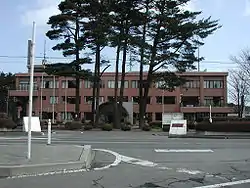
 Hashikami Town Office | |
 Flag  Seal | |
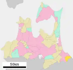
 Location of Hashikami in Aomori Prefecture | |
 Hashikami | |
| Coordinates: 40°27′9″N 141°37′16″E | |
| Country | Japan |
| Region | Tōhoku |
| Prefecture | Aomori |
| District | Sannohe |
| Area | |
| • Total | 94.01 km2 (36.30 sq mi) |
| Population (April 1, 2020) | |
| • Total | 13,494 |
| • Density | 140/km2 (370/sq mi) |
| Time zone | UTC+9 (Japan Standard Time) |
| Symbols | |
| • Tree | Zelkova serrata |
| • Flower | Rhododendron |
| • Bird | Japanese bush warbler |
| Phone number | 0178-88-2111 |
| Address | 1-87 Dobutsu, Hashikami-cho, Sannohe-gun, Aomori-ken 039-1201 |
| Website | Official website |
Geography
Hashikami occupies the far southeast corner of Aomori Prefecture, facing the Pacific Ocean. The coastline is rugged and highly indented, forming numerous small bays. Inland, the land is hilly, rising to the west to a height of 740 metres (2,430 ft) at the highest point. A portion of the coastal areas of the town were within the borders of the Tanesashi Kaigan Hashikamidake Prefectural Natural Park, which was incorporated into the Sanriku Fukkō National Park in 2013.[3][4]
Climate
The town has a cold maritime climate characterized by cool, short summers and long, cold winters with heavy snowfall (Köppen climate classification Cfa). The average annual temperature in Hashikami is 9.5 °C. The average annual rainfall is 1172 mm with September as the wettest month. The temperatures are highest on average in August, at around 22.2 °C, and lowest in January, at around -2.2 °C.[5]
Demographics
Per Japanese census data,[6] the population of Hashikami has peaked at around the year 2000 and is in gradual decline.
| Year | Pop. | ±% |
|---|---|---|
| 1920 | 6,530 | — |
| 1930 | 7,414 | +13.5% |
| 1940 | 8,288 | +11.8% |
| 1950 | 9,767 | +17.8% |
| 1960 | 10,260 | +5.0% |
| 1970 | 9,272 | −9.6% |
| 1980 | 10,199 | +10.0% |
| 1990 | 12,959 | +27.1% |
| 2000 | 15,618 | +20.5% |
| 2010 | 14,702 | −5.9% |
History
The area around Hashikami has been inhabited since ancient times, and a number of Buddhist temples in the area claim to have been founded in the Nara period or Heian period. During the Edo period, it was controlled by the Nambu clan of Morioka Domain, and after 1664, was part of Hachinohe Domain. With the establishment of the modern municipalities system on 1 April 1889, Hashikami Village was proclaimed from the merger of eight small hamlets. It was elevated to town status on May 1, 1980.
Government
Hashikami has a mayor-council form of government with a directly elected mayor and a unicameral town council of 14 members. Hashikami is part of Sannohe District which contributes three members to the Aomori Prefectural Assembly. In terms of national politics, the town is part of Aomori 2nd district of the lower house of the Diet of Japan.
Economy
The economy of Hashikami is heavily dependent on commercial fishing and agriculture, including the raising of chickens and pigs. The town also serves as a bedroom community for the nearby city of Hachinohe.
Education
Hashikami has six public elementary schools and two public middle schools operated by the town government, and one public elementary school and public middle school shared with Hachinohe. The town does not have a high school.
Transportation
Local attractions
Noted people from Hashikami
- Jūmonji Tomokazu – sumo wrestler
References
- "Official home page". Archived from the original on 2001-11-07. Retrieved 2005-01-29. Alt URL
- 詳細データ 青森県階上町. 市町村の姿 グラフと統計でみる農林水産業 (in Japanese). Ministry of Agriculture, Forestry and Fisheries. 2016. Retrieved 13 July 2017.
- 基礎情報 [Basic Information] (in Japanese). Ministry of the Environment. Archived from the original on 23 October 2013. Retrieved 22 October 2013.
- "National park of restoration". The Japan Times. 28 May 2013. Retrieved 22 October 2013.
- Hashikami climate data
- Hashikami population statistics
External links
| Wikimedia Commons has media related to Hashikami, Aomori. |
- Official Website (in Japanese)