Hirschau
Hirschau is a municipality in the Amberg-Sulzbach district, Upper Palatinate, Bavaria, Germany.
Hirschau | |
|---|---|
 Hirschau seen from Monte Kaolino | |
 Coat of arms | |
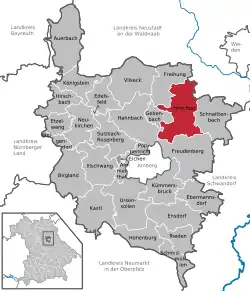
Location of Hirschau within Amberg-Sulzbach district  | |
 Hirschau  Hirschau | |
| Coordinates: 49°32′N 11°57′E | |
| Country | Germany |
| State | Bavaria |
| Admin. region | Upper Palatinate |
| District | Amberg-Sulzbach |
| Government | |
| • Mayor | Hermann Falk (CSU) |
| Area | |
| • Total | 74.90 km2 (28.92 sq mi) |
| Elevation | 411 m (1,348 ft) |
| Population (2019-12-31)[1] | |
| • Total | 5,630 |
| • Density | 75/km2 (190/sq mi) |
| Time zone | UTC+01:00 (CET) |
| • Summer (DST) | UTC+02:00 (CEST) |
| Postal codes | 92242 |
| Dialling codes | 09622 |
| Vehicle registration | AS |
| Website | hirschau.de |
Geography
Hirschau lies directly on the Bundesstraße 14 (Nuremberg - Rozvadov), 13 km northeast of Amberg and about 65 km east of Nuremberg. Apart from the main village Hirschau, the municipality consists of the following villages:
- Burgstall
- Dienhof
- Ehenfeld
- Krickelsdorf
- Kricklhof
- Krondorf
- Massenricht
- Obersteinbach
- Steiningloh
- Untersteinbach
- Weiher
Economy
Kaolin, used for the production of porcelain, has been mined at Hirschau since 1901. Interesting is the Monte Kaolino, a 120 meter high mound made from 32,000,000 tons of quartz sand from excess sand in years of operation. It is now used as a (sand) skiing/camping resort during the summer months. It is also the place where the yearly Sandboarding Championships are held.
References
- "Tabellenblatt "Daten 2", Statistischer Bericht A1200C 202041 Einwohnerzahlen der Gemeinden, Kreise und Regierungsbezirke". Bayerisches Landesamt für Statistik und Datenverarbeitung (in German). July 2020.
This article is issued from Wikipedia. The text is licensed under Creative Commons - Attribution - Sharealike. Additional terms may apply for the media files.