Hopen (Svalbard)
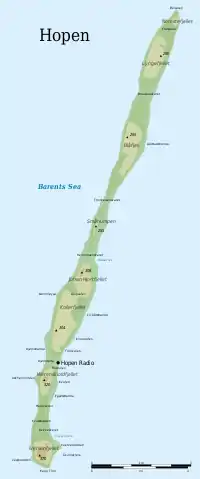
Hopen is an island in the southeastern part of the Svalbard archipelago (Norway). Hopen was discovered in 1596 by Jan Cornelisz Rijp during the third expedition by Willem Barentsz, trying to find the Northeast Passage. Later, in 1613, its name was given by Thomas Marmaduke of Hull, who named it after his former command, the Hopewell.
 Hopen in the southeast. | |
 Hopen Location of the island | |
| Geography | |
|---|---|
| Location | Arctic Ocean |
| Coordinates | 76°33′N 25°7′E |
| Archipelago | Svalbard |
| Area | 47 km2 (18 sq mi) |
| Length | 33 km (20.5 mi) |
| Width | 2 km (1.2 mi) |
| Highest elevation | 370 m (1210 ft) |
| Highest point | Iversenfjellet |
| Administration | |
Norway | |
| Demographics | |
| Population | 4 |
| Official name | Hopen |
| Designated | 12 November 2010 |
| Reference no. | 1957[1] |
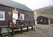
The Norwegian Meteorological Institute operates a manned weather station on the island with a staff of four persons. For the welfare of the crew, there are three cabins available on the island for their use.
During World War II, the Luftwaffe placed a meteorological team there under cover of Operation Zitronella.
On August 28, 1978 an early model Tupolev Tu-16 of the Soviet Air Force crashed on the island. All seven crew were killed in the accident. It was discovered two days later by the four-man Norwegian weather forecasting team. The USSR refused to admit the loss of an aircraft until the bodies of the crew were given to them. Norway transcribed the contents of the flight recorder over the objections of the Soviet government.[2][3][4]
Environment
A significant number of polar bears are found at Hopen in the winter;[5][6] moreover, the sub-population of Ursus maritimus found here is a genetically distinct taxon of polar bears associated with the Barents Sea region.[7]
Important Bird Area
The island has been identified as an Important Bird Area (IBA) by BirdLife International. It supports breeding populations of black-legged kittiwakes (40,000 pairs), thick-billed guillemots (150,000 individuals) and black guillemots (1000 pairs).[8]
Gallery
 Hopen meteorological station in 2019
 Hopen meteorological station, seen from north
 The southernmost point, Kapp Thor, and the highest point, Iversenfjellet (370 m) seen from south
See also
References
- "Hopen". Ramsar Sites Information Service. Retrieved 25 April 2018.
- Soviet Union Military Plane Crashes in Norway October 27, 1978 Retrieved August 15, 2017
- Svalbard Arctic out post at strategic crossroads September 9, 1980 Christian Science Monitor Retrieved August 15, 2017
- Umbreit, Andreas Bradt Svalbard: Spitzbergen with Frank Josef Land & Jan Mayen page 132 Retrieved August 15, 2017
- Derocher AE, Andersen M, Wiig Ø, Aars J, Hansen E, Biuw M. 2011. Sea ice and polar bear den ecology at Hopen Island, Svalbard. Marine Ecology Progress Series 441:273-279.
- Oysten Wiig and Kjell Isaksen
- C. Michael Hogan, 2008
- "Hopen Island". Important Bird Areas factsheet. BirdLife International. 2013. Retrieved 2013-08-22.
Bibliography
- C. Michael Hogan (2008) Polar Bear: Ursus maritimus, Globaltwitcher.com, ed. Nicklas Stromberg
- Oysten Wiig and Kjell Isaksen Seasonal Distribution of Harbour Seals, Bearded Seals, White Whales and Polar Bears in the Barents Sea