Interstate 94 in Minnesota
Interstate 94 (I-94) in the U.S. state of Minnesota runs 259 miles (417 km) east–west through the central portion of the state. The highway connects the cities of Moorhead, Fergus Falls, Alexandria, St. Cloud, Minneapolis, and Saint Paul.
| ||||
|---|---|---|---|---|
| Blue Star Memorial Highway Purple Heart Trail | ||||
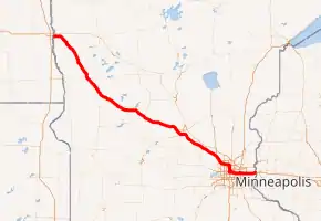
I-94 highlighted in red | ||||
| Route information | ||||
| Maintained by MnDOT | ||||
| Length | 259.49 mi[1] (417.61 km) | |||
| Major junctions | ||||
| West end | ||||
| ||||
| East end | ||||
| Location | ||||
| Counties | Clay, Wilkin, Otter Tail, Grant, Douglas, Todd, Stearns, Wright, Hennepin, Ramsey, Washington | |||
| Highway system | ||||
| ||||

Route description
I-94 enters the state from North Dakota at the city of Moorhead and heads southeast after serving Moorhead.
Traveling southeast from Moorhead, there are several places where the elevation of I-94 rises slightly; these are "beaches" that formed as the glacial lake rose or fell. Finally, at Rothsay, I-94 climbs the last beach line and enters terrain more typical for Minnesota. From Rothsay to the Twin Cities, the terrain of I-94 is rolling with frequent lakes visible from the highway.
I-94 traverses by Fergus Falls, Alexandria, and Sauk Centre on its way to St. Cloud. The "original main street" in Sauk Centre near I-94 commemorates the Sinclair Lewis novel that skewered this town.
Monticello is roughly the midpoint exurb for both St. Cloud and Minneapolis. Between exits 201 (Albertville) and 194 (Monticello) sits the Minnesota Road Research Facility.
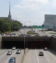
Upon arrival to the Twin Cities, I-94 first approaches Minneapolis from the north, then the highway turns east after passing through the Lowry Hill Tunnel and heads to Saint Paul while traveling east.
The road crosses the Mississippi River in Minneapolis between the Prospect Park and Seward neighborhoods. The highway joins Minneapolis and St. Paul together where it meets Minnesota State Highway 280 (MN 280). In Saint Paul, the routing of I-94 is set through the historic Rondo neighborhood, which prior to the highway's construction was the largest African-American community in Saint Paul.[2][3][4]
Upon leaving Saint Paul, the route travels through suburban Washington County and exits the state into Wisconsin between Lakeland, Minnesota, and Hudson, Wisconsin, while crossing the St. Croix River.
Legally, the Minnesota section of I-94 is defined as unmarked Legislative Route 392 in the Minnesota Statutes § 161.12(4).[5] I-94 is not marked with this legislative number along the actual highway.
History
I-94 in Minnesota was authorized as part of the original Interstate network in 1956. It was mostly constructed in the 1960s.
I-94 follows the original route of old U.S. Highway 52 (US 52) from Moorhead to St. Cloud, then I-94 stays south of the Mississippi River along the former route of old MN 152 between St. Cloud and the Twin Cities. I-94 then passes through both downtowns and exits toward Wisconsin along the former route of old US 12.
The first section of I-94 in Minnesota constructed was between Moorhead and Albany in the early 1960s, as an extension of the existing highway in North Dakota.
The section of I-94 between Minneapolis and Saint Paul was completed in 1968. In the Twin Cities, the construction of the highway was politically charged. The highway was built primarily through many working-class and black neighborhoods.[6][4] In Saint Paul, the routing of I-94 displaced the historic Rondo neighborhood, which prior to the highway construction was the largest African-American community in Saint Paul.[3][2][4]
The section of I-94 between Maple Grove and Brooklyn Center was completed in 1969.
The section of I-94 between Saint Augusta and Maple Grove was completed in 1973.
The section of I-94 between Albany and Saint Augusta was completed in 1977.
The section of I-94 from Brooklyn Center through north Minneapolis was completed in 1984. Like Rondo in the 1960s, this segment was through a primarily African-American and working-class neighborhood.[6]
The last section of I-94 in Minnesota constructed was the 10 miles (16 km) between its junction with I-494/I-694 at Woodbury and the Wisconsin state line at Lakeland. This was completed in 1985.
In 2004, a major traffic bottleneck was relieved when a third lane was constructed between Brooklyn Boulevard at Brooklyn Center and Hemlock Lane at Maple Grove. This is located immediately east of the I-494/I-694/I-94 interchange in Maple Grove, also known locally as the Fish Lake Interchange.
From September 2007 to October 2008, the Minnesota Department of Transportation (MnDOT) added a temporary extra lane to I-94 between northbound I-35W and MN 280 in the Twin Cities to help relieve traffic congestion caused by the collapse of the I-35W Mississippi River bridge. As a result, this portion of I-94 was not up to Interstate Highway standards during this time period.
Exit list
| County | Location | mi | km | Exit | Destinations | Notes |
|---|---|---|---|---|---|---|
| Red River of the North | 0.000 | 0.000 | Continuation into North Dakota | |||
| North Dakota–Minnesota state line | ||||||
| Clay | Moorhead | 0.577 | 0.929 | 1A | Breckenridge only signed eastbound; also access to Heritage-Hjemkomst Center, Concordia College, Minnesota State University, Bluestem Trollwood | |
| 1.538 | 2.475 | 1B | 20th Street | Eastbound exit and westbound entrance only | ||
| 2.709 | 4.360 | 2 | Signed as exits 2A (Main Avenue Southeast) and 2B (34th Street) eastbound | |||
| Glyndon Township | 6.075 | 9.777 | 6 | Sabin only signed eastbound; also access to US 10, Detroit Lakes, Airport, Glyndon, Dilworth | ||
| Elkton Township | 15.239 | 24.525 | 15 | Sabin only signed westbound | ||
| Barnesville–Humboldt township line | 22.700 | 36.532 | 22 | Barnesville only signed eastbound | ||
| Barnesville | 24.542 | 39.497 | 24 | Detroit Lakes only signed eastbound and Barnesville only signed westbound | ||
| Wilkin | Prairie View Township | 32.500 | 52.304 | 32 | ||
| Wilkin–Otter Tail county line | Rothsay | 38.226 | 61.519 | 38 | Rothsay | |
| Otter Tail | Fergus Falls Township | 50.479– 50.899 | 81.238– 81.914 | 50 | Northern end of US 59 overlap; Fergus Falls only signed eastbound, and Pelican Rapids/Detroit Lakes only signed westbound | |
| Fergus Falls | 54.167 | 87.173 | 54 | Western end of MN 210 overlap; also access to Lincoln Avenue, Airport | ||
| 55.860 | 89.898 | 55 | Wendell only signed eastbound | |||
| Buse Township | 57.888 | 93.162 | 57 | Eastern end of MN 210 overlap | ||
| Buse–Dane Prairie township line | 61.677 | 99.260 | 61 | Southern end of US 59 overlap; Elbow Lake only signed eastbound, and Fergus Falls only signed westbound | ||
| Tumuli Township | 67.624 | 108.830 | 67 | |||
| Grant | Pelican Lake Township | 77.099 | 124.079 | 77 | Also access to Battle Lake | |
| Douglas | Evansville Township | 82.908 | 133.427 | 82 | ||
| Brandon Township | 90.096 | 144.995 | 90 | |||
| La Grand Township | 97.415 | 156.774 | 97 | |||
| Alexandria | 100.685 | 162.037 | 100 | Western end of MN 27 overlap; Alexandria only signed eastbound | ||
| 103.037 | 165.822 | 103 | Also access to Alexandria Tech & Community College | |||
| Orange Township | 114.361 | 184.046 | 114 | Eastern end of MN 27 overlap | ||
| Todd | West Union Township | 119.148 | 191.750 | 119 | ||
| Stearns | Sauk Centre Township | 124.730 | 200.733 | 124 | Eastbound exit and westbound entrance only | |
| Sauk Centre | 127.179 | 204.675 | 127 | Willmar only signed eastbound, and Glenwood only signed westbound | ||
| Melrose Township | 131.079 | 210.951 | 131 | |||
| Melrose | 134.974 | 217.220 | 135 | |||
| Oak Township | 137.864 | 221.871 | 137 | |||
| Freeport | 140.865 | 226.700 | 140 | |||
| Albany | 146.916 | 236.438 | 147 | |||
| Avon | 153.313 | 246.733 | 153 | Also access to Holdingford | ||
| Avon Township | 156.531 | 251.912 | 156 | |||
| St. Joseph Township | 158.142 | 254.505 | 158 | Eastbound exit and westbound entrance only | ||
| 160.436 | 258.197 | 160 | ||||
| 164.514 | 264.760 | 164 | Signed as "St. Cloud, Rockville" eastbound and "Waite Park, Paynesville" westbound | |||
| St. Cloud | 167.137 | 268.981 | 167 | Signed as exits 167A (south) and 167B (north); also access to Waite Park | ||
| 171.223 | 275.557 | 171 | ||||
| 173.674 | 279.501 | 173 | Opportunity Drive (CSAH 75) | |||
| Wright | Clearwater | 178.953 | 287.997 | 178 | Also access to Clear Lake | |
| Silver Creek Township | 184.131 | 296.330 | 183 | Also access to Maple Lake | ||
| Monticello | 194.075 | 312.333 | 193 | |||
| 195.577 | 314.751 | 194 | ||||
| Albertville | 201.939 | 324.989 | 201 | No eastbound entrance; westbound exit via distributor ramp at exit 202 | ||
| 202.693 | 326.203 | 202 | Westbound exit is a distributor ramp for exits 202 and 201 and signed as 202&201 | |||
| St. Michael | 205.679 | 331.008 | 205 | |||
| Hennepin | Rogers | 208.352 | 335.310 | 207 | Westbound exit signed as 207A (south CR 81 and north MN 101) and 207B (north MN 101 flyover ramp bypassing Diamond Lake Road); eastbound signed as exits 207A and 207B; also access to Otsego | |
| Dayton | 210 | Interchange to be constructed in 2020-2021, will be built as a Diverging diamond interchange[7] | ||||
| Maple Grove | 212 | Eastbound exit and westbound entrance; opened December 2016 | ||||
| 214.367 | 344.990 | 213 | ||||
| 216.326 | 348.143 | 215 | ||||
| 216.990– 217.593 | 349.212– 350.182 | 216 | Western end of I-694 overlap; I-494/I-694 exit 27 | |||
| 218.084 | 350.972 | 28 | ||||
| Maple Grove–Brooklyn Park city line | 219.603 | 353.417 | 29 | Signed as exits 29A (south) and 29B (north) | ||
| Brooklyn Park | 220.153 | 354.302 | 30 | Boone Avenue | ||
| 221.078 | 355.791 | 31 | ||||
| Brooklyn Center | 223.103 | 359.049 | 33 | |||
| 224.258 | 360.908 | 34 | ||||
| 223.816– 225.620 | 360.197– 363.100 | 225 | Eastern end of I-694 overlap, I-694 exit 35B; Minneapolis–St. Paul Bypass | |||
| Minneapolis | 226.350– 227.351 | 364.275– 365.886 | 226 | 53rd Avenue North/49th Avenue North | ||
| 228.519 | 367.766 | 228 | Dowling Avenue North | |||
| 230.246– 230.590 | 370.545– 371.099 | 229 | Washington Avenue not signed eastbound | |||
| 231.350 | 372.322 | 230 | Western end of MN 55 overlap | |||
| 231.929– 232.234 | 373.254– 373.744 | 231A | Western end of US 12 overlap; no access to I-394/12 east; I-394 exit 8B | |||
| 232.403– 232.688 | 374.016– 374.475 | Lowry Hill Tunnel | ||||
| 232.862 | 374.755 | 231B | Virginia Triangle | |||
| 233.609 | 375.957 | 233B | Eastbound exit and westbound entrance; I-35W exit 16A; access via old MN 65 | |||
| 233.737 | 376.163 | 233A | 11th Street | Westbound exit and eastbound entrance | ||
| 233.696 | 376.097 | 233C | Eastbound exit and westbound entrance; I-35W exit 16A | |||
| 5th Avenue | Eastbound entrance only | |||||
| 233.904 | 376.432 | 233B | Westbound exit and eastbound entrance; I-35W exit 16B | |||
| 234.473 | 377.348 | 234A | Eastern end of MN 55 overlap | |||
| 234.473 | 377.348 | 234B | 7th Street | Westbound exit and eastbound entrance only | ||
| 234.730 | 377.761 | 234C | Westbound exit and eastbound entrance only | |||
| 235.296– 235.433 | 378.672– 378.893 | 235A | 25th Avenue/Riverside Avenue | |||
| 235.716– 235.906 | 379.348– 379.654 | Dartmouth Bridge over the Mississippi River | ||||
| 235.951– 236.085 | 379.726– 379.942 | 235B | Huron Boulevard | |||
| Ramsey | Saint Paul | 237.081 | 381.545 | 236 | ||
| 237.757 | 382.633 | 237 | Cretin Avenue/Vandalia Street | |||
| 239.065 | 384.738 | 238 | ||||
| 239.564 | 385.541 | 239A | Hamline Avenue | Westbound exit only | ||
| 240.063 | 386.344 | 239B | ||||
| 241.059 | 387.947 | 240 | ||||
| 241.868 | 389.249 | 241A | ||||
| 242.040 | 389.526 | 241B | 10th Street, 5th Street | Eastbound exit and westbound entrance | ||
| 242.045 | 389.534 | 242A | 12th Street – State Capitol | Westbound exit and eastbound entrance only | ||
| 242.252– 242.554 | 389.867– 390.353 | 241C | Western end of I-35E overlap; westbound exit and eastbound entrance only; I-35E exit 107B | |||
| 242.768– 243.146 | 390.697– 391.306 | 242B | Eastern end of I-35E overlap; western end of US 10 overlap; I-35E exit 107A | |||
| 243.067 | 391.178 | 242C | 7th Street | Eastbound exit only | ||
| 243.448 | 391.792 | 242D | Eastern end of US 52 overlap; 6th Street not signed eastbound | |||
| 244.070 | 392.793 | 243 | Western end of US 61 overlap | |||
| 245.566 | 395.200 | 244 | Eastern end of US 10/US 61 overlap | |||
| 246.370 | 396.494 | 245 | ||||
| 246.866 | 397.292 | 246A | Ruth Street | Eastbound exit and westbound entrance only | ||
| Saint Paul–Maplewood city line | 247.370 | 398.103 | 246 | |||
| Maplewood | 248.328 | 399.645 | 247 | |||
| Washington | Woodbury–Oakdale city line | 249.449– 249.848 | 401.449– 402.091 | 249 | Minneapolis–St. Paul Bypass via I-694 | |
| Woodbury–Lake Elmo city line | 250.838 | 403.685 | 250 | |||
| 251.378 | 404.554 | 251 | ||||
| 253.377 | 407.771 | 253 | Western end of MN 95 overlap | |||
| Lakeland | 258.918 | 416.688 | 258 | Eastern end of MN 95 overlap | ||
| St. Croix River | 259.663 | 417.887 | Minnesota–Wisconsin state line | |||
| Continuation into Wisconsin | ||||||
1.000 mi = 1.609 km; 1.000 km = 0.621 mi
| ||||||
Auxiliary routes
References
- Adderly, Kevin (January 30, 2018). "Table 1: Main Routes of the Dwight D. Eisenhower National System of Interstate and Defense Highways as of December 31, 2017". Route Log and Finder List. Federal Highway Administration. Retrieved September 29, 2018.
- "Rondo Neighborhood & I-94: Overview". Minnesota History Center, Gale Family Library. Retrieved July 13, 2016.
- Yuen, Laura (April 29, 2010). "Central Corridor: In the Shadow of Rondo". MPR News. Minnesota Public Radio. Retrieved July 13, 2016.
- Rupar, Aaron (August 19, 2014). "St. Paul Map Shows How I-94 Cut Through Heart of City's African-American Neighborhood". City Pages. Retrieved July 13, 2016.
- Rupar, Aaron (August 18, 2014). "'Racist' Twin Cities Maps Make Point About Interstate Highways". City Pages. Retrieved July 13, 2016.
- https://www.dot.state.mn.us/i94-mg-clearwater
External links
- Steve Riner Details of Routes 76 to 100. Unofficial Minnesota Highways Page.
| Previous state: North Dakota |
Minnesota | Next state: Wisconsin |