Jacareacanga
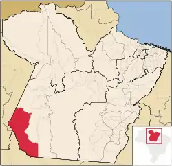
Jacareacanga is a municipality in the state of Pará in the Northern region of Brazil. It is at the very centre of South America.[2][3][4][5]
Jacareacanga | |
|---|---|
Municipality | |
 Location in Pará | |
 Jacareacanga Location in Brazil | |
| Coordinates: 6.2226°S 57.7617°W | |
| Country | |
| Region | Northern |
| State | Pará |
| Mesoregion | Sudoeste Paraense |
| Population (2020 [1]) | |
| • Total | 7,590 |
| Time zone | UTC -3 |
Conservation
The municipality contains the 739,806 hectares (1,828,100 acres) Crepori National Forest, created in 2006.[6] It contains 14% of the 1,988,445 hectares (4,913,550 acres) Tapajós Environmental Protection Area, created in 2006.[7] It contains part of the Amaná National Forest, a 539,571 hectares (1,333,310 acres) sustainable use conservation unit created in 2006.[8]
Indigenous territories
The municipality contains the 126,000 hectares (310,000 acres) Sai Cinza Indigenous Territory, established in 1991.[9] It contains part of the 2,382,000 hectares (5,890,000 acres) Mundurucu Indigenous Territory, established in 2004.[10] It would contain part of the reservoir of the proposed Chacorão Dam on the Tapajós, if approved.[11] However, as of 2010 Eletronorte had not applied for registration with the National Electricity Agency to start feasibility studies for the Chacorão hydroelectric power plant, since the dam would flood parts of the Mundurucu and Sai Cinza indigenous territories. A spokesman said that without a decree to regulate the constitution there was no way to undertake projects in indigenous territories.[12]
See also
References
- IBGE 2020
- "Divisão Territorial do Brasil" (in Portuguese). Divisão Territorial do Brasil e Limites Territoriais, Instituto Brasileiro de Geografia e Estatística (IBGE). July 1, 2008. Retrieved December 17, 2009.
- "Estimativas da população para 1º de julho de 2009" (PDF) (in Portuguese). Estimativas de População, Instituto Brasileiro de Geografia e Estatística (IBGE). August 14, 2009. Retrieved December 17, 2009.
- "Ranking decrescente do IDH-M dos municípios do Brasil" (in Portuguese). Atlas do Desenvolvimento Humano, Programa das Nações Unidas para o Desenvolvimento (PNUD). 2000. Archived from the original on October 3, 2009. Retrieved December 17, 2009.
- "Produto Interno Bruto dos Municípios 2002-2005" (PDF) (in Portuguese). Instituto Brasileiro de Geografia e Estatística (IBGE). December 19, 2007. Archived from the original (PDF) on October 2, 2008. Retrieved December 17, 2009.
- FLONA do Crepori (in Portuguese), ISA: Instituto Socioambiental, retrieved 2017-02-14
- APA do Tapajós (in Portuguese), ISA: Instituto Socioambiental, retrieved 2017-02-11
- Unidade de Conservação: Floresta Nacional do Amaná (in Portuguese), MMA: Ministério do Meio Ambiente, retrieved 2016-05-30
- Terra Indígena Sai Cinza (in Portuguese), ISA: Instituto Socioambiental, retrieved 2017-02-14
- Terra Indígena Mundurucu (in Portuguese), ISA: Instituto Socioambiental, retrieved 2017-02-14
- Usinas do Tapajós (in Portuguese), Grupo de Estudo Tapajós, retrieved 2017-02-13
- Couto, Fábio (7 May 2010), "Usinas-plataforma: aposta no baixo impacto", Canal Energia (in Portuguese), Eletronorte, retrieved 2017-02-13
