Jispa
Jispa (elevation 3,200 m or 10,500 ft; population 332)[1] is a village in Lahaul, in the Indian state of Himachal Pradesh.
Jispa | |
|---|---|
village | |
 | |
 Jispa Location in Himachal Pradesh, India  Jispa Jispa (India) | |
| Coordinates: 32°38′0″N 77°10′0″E | |
| Country | |
| State | Himachal Pradesh |
| District | Lahaul and Spiti |
| Elevation | 3,200 m (10,500 ft) |
| Population (2001) | |
| • Total | 332 |
| Languages | |
| • Official | Hindi |
| Time zone | UTC+5:30 (IST) |
| Vehicle registration | HP |

Jispa Monastery

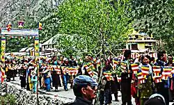
Pilgrims at Jispa for Dalai Lama's teachings. August 2010

Jispa - hotel. 2010
Jispa is located 20 km north of Keylong[2][3] and 7 km south of Darcha,[4] along the Manali-Leh Highway and the Bhaga river.[3] There are approximately 20 villages between Jispa and Keylong.[5]
According to the 2001 census, of the town's 332 residents, 235 were male and 97 were female.[1] Four belong to scheduled castes, and 149 belong to scheduled tribes.[1] The village has 78 households.[1]

Houses in Jispa
The village has a helipad, a post office,[6] and a monastery.[7] Travellers often stop for the night here; the village has a hotel, a mountaineers' hut, and a campground.[2][3][4] Jispa also has a small folk museum.[2]
Footnotes
| Wikimedia Commons has media related to Jispa. |
- 2001 India Census. See census.gov.in Archived 14 May 2007 at the Wayback Machine (requires registration).
- Joe Bindloss & Sarina Singh. India. Lonely Planet (2007), p. 341. ISBN 978-1-74104-308-2.
- "Jispa" Archived 20 August 2010 at the Wayback Machine. Himachal Tourism (2009). Accessed 22 October 2009.
- David Abram. Rough Guide to India. Rough Guides (2003), p. 523. ISBN 978-1-84353-089-3.
- Sudha Mahalingam. "On the trail of two rivers". Frontline (18–31 December 2004).
- S.C. Bajpai. Lahaul-Spiti: A Forbidden Land in the Himalayas. Indus Publishing (2002), p. 131. ISBN 978-81-7387-113-9.
- Sandeep Silas. Discover India by Rail. Sterling Publishers (2005), p. 187. ISBN 978-81-207-2939-1.
This article is issued from Wikipedia. The text is licensed under Creative Commons - Attribution - Sharealike. Additional terms may apply for the media files.