Jiwaka Province
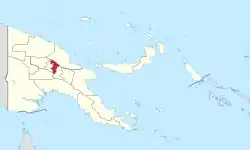
Jiwaka is a province of Papua New Guinea. The provincial capital is temporarily located in Kurumul. Mostly all provincial matters are handled in Kurumul while few are handled in Banz and Minj.
Jiwaka Province | |
|---|---|
 Flag | |
 Jiwaka Province in Papua New Guinea | |
| Coordinates: 6°0′S 144°35′E | |
| Country | Papua New Guinea |
| Formation | 2012 |
| Capital | Kurumul |
| Districts | |
| Government | |
| • Governor | Dr William Tongamp (2012-) |
| Area | |
| • Total | 4,798 km2 (1,853 sq mi) |
| Population (2011 census) | |
| • Total | 343,987 |
| • Density | 72/km2 (190/sq mi) |
| Time zone | UTC+10 (AEST) |
| HDI (2018) | 0.539[1] low · 15th of 22 |
The province covers an area of 4,798 km²,[2] and there are 343,987 inhabitants (2011 census final figures[3]—2000 census 185,641). Jiwaka province officially came into being on 17 May 2012,[4] comprising three districts[5][6] previously part of Western Highlands Province. Mount Wilhelm, the tallest mountain in Papua New Guinea, is on the border of Jiwaka.
"Jiwaka" is a portmanteau word combining the first two letters each of Jimi, Waghi and Kambia. The inclusion of the Anglimp Rural LLG in Jiwaka was controversial,[7] and will be reviewed after the 2012 General Election.[8]
Geographical and Natural Resources
Jiwaka is located in a very fertile land (Waghi Valley). The Waghi River runs between the valley and most of the people benefit out of it. Besides the Waghi River, the land is naturally fertile and people harvest the best food from it. The 3 resources of the Jiwaka people are coffee, tea and human resources. (SKM-Manda Dam-Tukoi)
Districts and LLGs
There are three districts in the province. Each district has one or more Local Level Government (LLG) areas. For census purposes, the LLG areas are subdivided into wards and those into census units.[9][10][11]
| District | District Capital | LLG Name |
|---|---|---|
| Anglimp-South Waghi District | Minj | Anglimp Rural |
| South Waghi Rural | ||
| Jimi District | Tabibuga | Jimi Rural |
| Kol Rural | ||
| North Waghi District | Banz | North Waghi Rural |
| Nondugl Rural |
Provincial leaders
Chairman of the Jiwaka Transitional Authority (2010–2012)
| Chairman | Term |
|---|---|
| Philip Kapal | 2010–2011 |
Governors (2012–present)
| Governor | Term |
|---|---|
| William Tongamp | 2012–present |
Members of the National Parliament
The province and each district is represented by a Member of the National Parliament. There is one provincial electorate and each district is an open electorate.
| District | Member |
|---|---|
| Jiwaka Provincial | William Tongamp |
| Anglimp-South Waghi Open | Joe Kuli |
| Jimi Open | Wake Goi |
| North Waghi Open | Fabian Pok |
References
- "Sub-national HDI - Area Database - Global Data Lab". hdi.globaldatalab.org. Retrieved 2020-04-18.
- "Western Highlands Province" (PDF). The National Research Institute. March 2010. Sections for Angalimp South Waghi, Jimi & North Waghi Districts. Archived from the original (PDF) on 2013-07-22. Retrieved 2012-05-22.
- "Population at a glance".
- "Hela, Jiwaka declared". The National (Papua New Guinea). 2012-05-17. Retrieved 2012-05-22.
- John Pangkatana (2011-09-29). "Anglimp to vote under Jiwaka". Post-Courier Online. Archived from the original on 2012-09-10. Retrieved 2012-05-28.
- Yvonne Haip (2012-03-16). "Leaders: Anglimp roll is flawed". The National. Retrieved 2012-05-28.
- Johnny Poiya (2011-09-07). "Anglimp rejects Jiwaka". Post-Courier Online. Archived from the original on 2013-10-29. Retrieved 2012-05-29.CS1 maint: bot: original URL status unknown (link)
- "Anglimp to be part of WHP". The National. 2012-01-16. Retrieved 2012-05-29.
- National Statistical Office of Papua New Guinea
- "Census Figures by Wards - Highlands Region". www.nso.gov.pg. 2011 National Population and Housing Census: Ward Population Profile. Port Moresby: National Statistical Office, Papua New Guinea. 2014.
- "Final Figures". www.nso.gov.pg. 2011 National Population and Housing Census: Ward Population Profile. Port Moresby: National Statistical Office, Papua New Guinea. 2014.