Kalayaan, Laguna
Kalayaan, officially the Municipality of Kalayaan (Tagalog: Bayan ng Kalayaan), is a 3rd class municipality in the province of Laguna, Philippines. According to the 2015 census, it has a population of 23,269 people. [3]
Kalayaan | |
|---|---|
| Municipality of Kalayaan | |
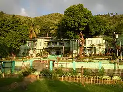
 Kalayaan Plaza | |
 Seal | |
| Nickname(s): Laguna's Symbol of Peace and Unity | |
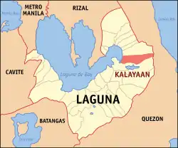
 Map of Laguna with Kalayaan highlighted | |
OpenStreetMap 
| |
.svg.png.webp) Kalayaan Location within the Philippines | |
| Coordinates: 14°21′N 121°34′E | |
| Country | |
| Region | Calabarzon (Region IV-A). |
| Province | Laguna |
| District | 4th District |
| Founded | May 17, 1956 |
| Barangays | 3 (see Barangays) |
| Government | |
| • Type | Sangguniang Bayan |
| • Mayor | Sandy P. Laganapan |
| • Vice Mayor | John Edward Kenneth M. Ragaza |
| • Representative | Benjamin C. Agarao Jr. |
| • Electorate | 15,910 voters (2019) |
| Area | |
| • Total | 46.60 km2 (17.99 sq mi) |
| Elevation | 286 m (938 ft) |
| Population | |
| • Total | 23,269 |
| • Density | 500/km2 (1,300/sq mi) |
| • Households | 5,109 |
| Economy | |
| • Income class | 3rd municipal income class |
| • Poverty incidence | 11.86% (2015)[4] |
| • Revenue | ₱83,196,251.10 (2016) |
| Time zone | UTC+8 (PST) |
| ZIP code | 4015 |
| PSGC | |
| IDD : area code | +63 (0)49 |
| Climate type | tropical monsoon climate |
| Native languages | Tagalog |
| Website | www |
Kalayaan is in the fourth district of the province of Laguna and can be reached three hours by land from Manila. It is the home of approximately 24,214 citizenry. The municipality is home to a hydroelectric power plant, the only pumped storage facility in the Philippines, the Kalayaan Pumped Storage Power Plant located in Brgy. San Juan, that contributes substantially to the income and an economic activity that is anchored on agriculture. It has complied with Ecological Solid Waste Management Act of 2000 (R.A. 9003) by constructing a Category-I Sanitary Landfill under LISCOP, considered as one of its kind on the municipal level in the Province of Laguna, which aims to put into practice the segregation and proper disposal of solid waste for the protection of environment.[5]
Kalayaan is roughly rectangular in shape, with a hilly terrain on most of its eastern side, while relatively flat on its western side. Its highest elevations are from 400 to 418 metres. These are found in Sitio Santo Angel, Malaking Pulo, and Cabuhayan in Barangay San Juan, and Sitio Lamao in Barangay San Antonio. Approximately three fourths of the total land area are with terrain 300 metres above sea level. Its lowest points are from 5 to 20 metres along the western sections of Barangays San Juan and Longos towards Laguna de Bay.
The municipality was formerly called Longos until 1956 when it was changed to its present name.[6]
Historical background
A marker posted in the municipal building of Kalayaan reads: “On this site grew a coconut tree with three branches interpreted by our forebears as the future site of our municipal building; three branches being San Juan, Longos and San Antonio.”[5]
Today, the belief had been realized but digging through historical records, it seems that the place is still made up of the three original visitas of Babaye (now Longos), Abacao (now San Juan) and San Pablo (now San Antonio). Babaye got its name when the Spaniards came and found women washing clothes in the brook. When the Spaniards continued their aim to conquer the land and a little north of Babaye, they saw a place where people dried abaca and named the place Abacao. The Spaniards claimed the mountains east of Babaye and named the village found there in honor of San Pablo.[5]
On March 30, 1946, Executive Order No. 127 which ordered the transfer of the seat of government from Longos to San Juan was signed by Pres. Manuel Roxas. From then on, a part of San Juan became the Poblacion, while Longos, San Antonio and the rest of San Juan became its barangays.[5]
Geography
Kalayaan is located approximately 14º20’ to 14°22’ latitude and 121º28’ to 121º38’ longitude. It is bounded by the Municipality of Paete on the north, Lumban on the south, Laguna de Bay on the west and Mauban, Quezon Province on the east. The municipality is about 15 kilometers from the capital town of Santa Cruz and 102 kilometers from Metro Manila. It could be reached via the Manila South Expressway and an artery of the national road southward from Calamba and northward from Pagsanjan.[5]
Barangays
Kalayaan is politically subdivided into 3 barangays: [2]
- Longos (old capital town)
- San Antonio
- San Juan
Climate
| Climate data for Kalayaan, Laguna | |||||||||||||
|---|---|---|---|---|---|---|---|---|---|---|---|---|---|
| Month | Jan | Feb | Mar | Apr | May | Jun | Jul | Aug | Sep | Oct | Nov | Dec | Year |
| Average high °C (°F) | 24 (75) |
25 (77) |
26 (79) |
29 (84) |
29 (84) |
28 (82) |
27 (81) |
27 (81) |
27 (81) |
26 (79) |
25 (77) |
24 (75) |
26 (80) |
| Average low °C (°F) | 20 (68) |
20 (68) |
20 (68) |
21 (70) |
22 (72) |
22 (72) |
22 (72) |
22 (72) |
22 (72) |
21 (70) |
21 (70) |
20 (68) |
21 (70) |
| Average precipitation mm (inches) | 58 (2.3) |
41 (1.6) |
32 (1.3) |
29 (1.1) |
91 (3.6) |
143 (5.6) |
181 (7.1) |
162 (6.4) |
172 (6.8) |
164 (6.5) |
113 (4.4) |
121 (4.8) |
1,307 (51.5) |
| Average rainy days | 13.4 | 9.3 | 9.1 | 9.8 | 19.1 | 22.9 | 26.6 | 24.9 | 25.0 | 21.4 | 16.5 | 16.5 | 214.5 |
| Source: Meteoblue [7] | |||||||||||||
Demographics
| Year | Pop. | ±% p.a. |
|---|---|---|
| 1903 | 2,435 | — |
| 1918 | 3,103 | +1.63% |
| 1939 | 3,519 | +0.60% |
| 1948 | 3,817 | +0.91% |
| 1960 | 5,007 | +2.29% |
| 1970 | 6,957 | +3.34% |
| 1975 | 8,501 | +4.10% |
| 1980 | 10,247 | +3.81% |
| 1990 | 13,118 | +2.50% |
| 1995 | 16,955 | +4.92% |
| 2000 | 19,580 | +3.13% |
| 2007 | 21,203 | +1.10% |
| 2010 | 20,944 | −0.45% |
| 2015 | 23,269 | +2.03% |
| Source: Philippine Statistics Authority [3] [8] [9][10] | ||

In the 2015 census, the population of Kalayaan, Laguna, was 23,269 people, [3] with a density of 500 inhabitants per square kilometre or 1,300 inhabitants per square mile.
References
- Municipality of Kalayaan | (DILG)
- "Province: Laguna". PSGC Interactive. Quezon City, Philippines: Philippine Statistics Authority. Retrieved 12 November 2016.
- Census of Population (2015). "Region IV-A (Calabarzon)". Total Population by Province, City, Municipality and Barangay. PSA. Retrieved 20 June 2016.
- "PSA releases the 2015 Municipal and City Level Poverty Estimates". Quezon City, Philippines. Retrieved 1 January 2020.
- "Kalayaan". Philippines Department of the Interior and Local Government. Retrieved 28 September 2020.
 This article incorporates text from this source, which is in the public domain.
 - Republic Act No. 1417 Archived 2012-06-01 at the Wayback Machine, PhilippineLaw, retrieved 2012
- "Kalayaan: Average Temperatures and Rainfall". Meteoblue. Retrieved 11 May 2020.
- Census of Population and Housing (2010). "Region IV-A (Calabarzon)". Total Population by Province, City, Municipality and Barangay. NSO. Retrieved 29 June 2016.
- Censuses of Population (1903–2007). "Region IV-A (Calabarzon)". Table 1. Population Enumerated in Various Censuses by Province/Highly Urbanized City: 1903 to 2007. NSO.
- "Province of Laguna". Municipality Population Data. Local Water Utilities Administration Research Division. Retrieved 17 December 2016.
External links
| Wikimedia Commons has media related to Kalayaan, Laguna. |

