Kaneyama, Fukushima
Kaneyama (金山町, Kaneyama-machi) is a town located in Fukushima Prefecture, Japan. As of 1 March 2020, the town had an estimated population of 1972, in 1037 households [1] and a population density of 6.7 persons per km². The total area is 293.92 square kilometres (113.48 sq mi). Kaneyama is noted for its spectacular scenery.
Kaneyama
金山町 | |
|---|---|
 Kaneyama Town Hall | |
 Flag  Seal | |
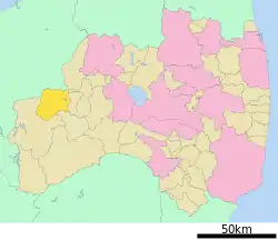
 Location of Kaneyama in Fukushima Prefecture | |
 Kaneyama | |
| Coordinates: 37°27′13.3″N 139°32′28.7″E | |
| Country | Japan |
| Region | Tōhoku |
| Prefecture | Fukushima |
| District | Ōnuma |
| Area | |
| • Total | 293.92 km2 (113.48 sq mi) |
| Population (March 2020) | |
| • Total | 1,972 |
| • Density | 6.7/km2 (17/sq mi) |
| Time zone | UTC+9 (Japan Standard Time) |
| - Tree | Paulownia tomentosa |
| - Flower | Magnolia kobus |
| - Bird | Common cuckoo |
| Phone number | 0241-45-2211 |
| Address | 393 Yachi Kawaguchi Kaneyama-machi, Ōnuma-gun, Fukushima-ken 968-0011 |
| Website | Official website |

Geography
Kaneyama is located in mountainous northwest of the Aizu region of Fukushima Prefecture, bordered Niigata Prefecture to the west. Kaneyama has no town center, but is an artificial construct made up of a number of small villages scattered alongside the Tadami River. Kaneyama has many hot springs.
- Mountains : Mount Mikagura (1386.5 m), Mount Takamori
- Rivers : Tadami River
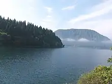
- Lakes: Lake Numazawa
Climate
Kaneyama has a Humid continental climate (Köppen Dfb) characterized by warm summers and cold winters with heavy snowfall. The average annual temperature in Kaneyama is 9.1 °C. The average annual rainfall is 1615 mm with September as the wettest month. The temperatures are highest on average in August, at around 23.5 °C, and lowest in January, at around -2.6 °C.[2]
Demographics
Per Japanese census data,[3] the population of Kaneyama peaked in the 1950s and has declined steadily over the past 60 years. It is now only third of what it was a century ago.
| Year | Pop. | ±% |
|---|---|---|
| 1920 | 6,817 | — |
| 1930 | 7,293 | +7.0% |
| 1940 | 7,945 | +8.9% |
| 1950 | 9,157 | +15.3% |
| 1960 | 10,119 | +10.5% |
| 1970 | 6,511 | −35.7% |
| 1980 | 4,790 | −26.4% |
| 1990 | 3,549 | −25.9% |
| 2000 | 3,204 | −9.7% |
| 2010 | 2,462 | −23.2% |
History
The area of present-day Kaneyama was part of ancient Mutsu Province and formed part of the holdings of Aizu Domain during the Edo period. After the Meiji Restoration, it was organized as part of Ōnuma District in Fukushima Prefecture. After the Meiji restoration, the villages of Yokota, Kawaguchi, Numzawa and Honna were established with the creation of the modern municipalities system on April 1, 1889. These villages merged on July 1, 1955 to form the village of Kaneyama, which was raised to town status on March 31, 1958.
One of the hamlets in the town, Mifuke, on the banks of the Tadami River, was struck by a landslide in April 1964, was abandoned, and now is a ghost town only visited occasionally by tourists and former residents. The displaced people were integrated into the village of Amenuma across the river.[4][5]
Economy
Hydroelectric power generation from numerous dams on the Tadami River is the primary source of revenue for the village
Education
Kaneyama has two public elementary schools and one public junior high school operated by the town government. The town has one public high school operated by the Fukushima Prefectural Board of Education.
- Fukushima Prefectural Kawaguchi High School
Transportation
Railway
- Aizu-Mizunuma - Aizu-Nakagawa - Aizu-Kawaguchi - (Closed due to line damage) - Honna - Aizu-Kosugawa - Aizu-Yokota - Aizu-Ōshio
Highway
Local attractions
- Lake Numazawa
- Numazawa Onsen
- Oshio Onsen
References
- Kaneyama town official statistics(in Japanese)
- Kaneyama climate data
- Kaneyama population statistics
- "Mugenkyo no Watashi". Okuaizu. Archived from the original on 16 September 2018.
- "Foggy Fukushima river tour draws influx of visitors". The Japan Times. Fukushima Minpo. 16 September 2018. Archived from the original on 16 September 2018.
External links
![]() Media related to Kaneyama, Fukushima at Wikimedia Commons
Media related to Kaneyama, Fukushima at Wikimedia Commons
- Official Website (in Japanese)