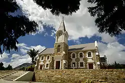
Kareedouw
Kareedouw is a town in the Eastern Cape province of South Africa. It is the administrative centre for the Kou-Kamma Municipality in the Sarah Baartman District of the Eastern Cape.
Kareedouw | |
|---|---|
 Nederduits Gereformeerde Kerk church in Kareedouw | |
 Kareedouw  Kareedouw | |
| Coordinates: 33°57′7″S 24°17′22″E | |
| Country | South Africa |
| Province | Eastern Cape |
| District | Sarah Baartman |
| Municipality | Kou-Kamma |
| Area | |
| • Total | 15.10 km2 (5.83 sq mi) |
| Population (2011)[1] | |
| • Total | 4,985 |
| • Density | 330/km2 (860/sq mi) |
| Racial makeup (2011) | |
| • Black African | 32.8% |
| • Coloured | 56.5% |
| • Indian/Asian | 0.3% |
| • White | 9.5% |
| • Other | 1.0% |
| First languages (2011) | |
| • Afrikaans | 72.6% |
| • Xhosa | 22.1% |
| • English | 2.4% |
| • Other | 2.9% |
| Time zone | UTC+2 (SAST) |
| Postal code (street) | 6400 |
| PO box | 6400 |
| Area code | 042 |
History
The town's name derives from the Khoe phrase meaning "path by the karee trees". The town was established by white settlers around the year 1750.[2]
Tourism
Kareedouw is the gateway to the Langkloof Mountains; 120 km from Port Elizabeth. It nestles between the Tsitsikamma and Suuranys Mountains. A popular activity is 4x4 trips through the Suurveld, Kouga and Baviaanskloof Wilderness areas, canoe trips on the Kouga River, and camping and hiking trails. [3][4][5]
Notable residents
One important person connected to the town is John Vorster, prime minister of South Africa from 1966 to 1978, who had a house on the coast and is buried in the cemetery next to the Dutch Reformed Church. [6]
- Balthazar Johannes Vorster lies buried under a large black marble slab in "heroes' acre" in the remote Eastern Cape town of Kareedouw, at the foot of the Langkloof. ... As late as 2002, the Kareedouw hospital still treated black and white patients at separate entrances... [7]
Locations
There is a Kareedouw Peak and a Kareedouw Pass.[8]
The Tsitsikamma mountains are a mountain range located in the Garden Route region of the southern South African coast in the Western Cape and Eastern Cape provinces. They stretch just over 80 km from the Keurbooms River in the west just north of Plettenberg Bay, to Kareedouw Pass in the east.[9] The Formosa Conservation Area is adjacent to the Jagersbos farm, about 15 km west of Kareedouw.[10]
There are medical and pharmaceutical facilities, the provincial B.J. Vorster Hospital, a public library, and a Lutheran Missionary Monument at or near Kareedouw.[11][12][13]
References
- "Main Place Kareedouw". Census 2011.
- "Langkloof Route". Open Africa. 8 July 2002. Retrieved 30 December 2013.
- "Four Star Hotels in Kareedouw". Essential Travel Info. 31 August 2012. Retrieved 30 December 2013.
- Archived 29 June 2008 at the Wayback Machine
- "Ghost of apartheid haunts George - PW Botha's town". Anarkismo. Retrieved 30 December 2013.
- http://www.aluka.org/action/doBrowse?sa=1&sa=1&br=tax-epithets-derived%7Cnamed-as%7C-no_t-&t=149937&cookieSet=1%5B%5D
- "TSITSIKAMMA Mountain Reserve". Retrieved 30 December 2013.
- https://web.archive.org/web/20070824155735/http://academic.sun.ac.za/botzoo/tolley/Tolley%20and%20Burger%20AJH%2053%282%29%20123-133.pdf
- Archived 12 April 2009 at the Wayback Machine
- "Background". Archive.is. 21 April 2006. Archived from the original on 11 July 2012. Retrieved 30 December 2013.
- https://web.archive.org/web/20080125051933/http://www.cacadu.co.za/municipality/article/59/Exploring_in_the_Cacadu_district/. Archived from the original on 25 January 2008. Retrieved 20 April 2009. Missing or empty
|title=(help)
| Wikimedia Commons has media related to Kareedouw. |
.svg.png.webp)