Kingston On Murray, South Australia
Kingston On Murray (formerly Thurk and Kingston O.M.) is a town on the south bank of the Murray River in the Riverland region of South Australia. Its name is ultimately derived from Charles Kingston who was Premier of South Australia from 1893-99.[7] At the 2006 census, the town had a population of 257.[8]
| Kingston On Murray South Australia | |||||||||||||||
|---|---|---|---|---|---|---|---|---|---|---|---|---|---|---|---|
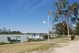
 Houseboats on the Murray River | |||||||||||||||
 Kingston On Murray | |||||||||||||||
| Coordinates | 34°13′23″S 140°20′39″E[1] | ||||||||||||||
| Population | 317 (2016 census)[2] | ||||||||||||||
| Established | 21 November 1918 (town) 28 September 2000 (locality)[3][4] | ||||||||||||||
| Postcode(s) | 5331[5] | ||||||||||||||
| Time zone | ACST (UTC+9:30) | ||||||||||||||
| • Summer (DST) | ACST (UTC+10:30) | ||||||||||||||
| Location | |||||||||||||||
| LGA(s) | District Council of Loxton Waikerie[1] | ||||||||||||||
| County | Albert[1] | ||||||||||||||
| State electorate(s) | Chaffey | ||||||||||||||
| Federal Division(s) | Barker | ||||||||||||||
| |||||||||||||||
| |||||||||||||||
| Footnotes | Adjoining localities[1] | ||||||||||||||
History
The town was surveyed in January 1915 and originally proclaimed as Thurk on 21 November 1918.[1][3] Its size was reduced on 19 July 1934 and again on 13 July 1939. The name was derived from Thurk Homestead where the word Thurk is itself derived from an aboriginal word tharko that means the mouth.[1][9][10]
The town's name was changed from Thurk to Kingston O.M. on 19 September 1940. The name was derived from the Kingston Village Settlement Area, a settlement which was established in 1896 and whose name is derived from Charles Kingston, the then Premier of South Australia.[1][11][12][13]
The name was altered at the request of residents from Kingston O.M. to Kingston On Murray on 31 March 1994.[1][14] Erratum published in Government Gazette 24 November 1994 to correct the incorrect use of hyphens in the original Notice to Assign.[1][15]
Boundaries for the locality of Kingston on Murray were created on 28 September 2000 and include the sites of the Kingston Ferry Shack Site and the government town of Kingston On Murray.[1][4]
Overview
The Sturt Highway now bypasses the town and crosses the Murray River over a bridge. Before the bridge was opened in 1973,[16] there were two vehicular cable ferries in the town to carry traffic over the river.
Kingston On Murray is in the District Council of Loxton Waikerie, the state electoral district of Chaffey and the federal Division of Barker.
Kingston Estate and Accolade Wines' Banrock Station brand have wineries near Kingston On Murray. There is also the Ramsar-listed Banrock Station Wetlands.
The historic Kingston On Murray Pump Site and Feeder Tank Ruins are listed on the South Australian Heritage Register.[17]
References
- "Search results for 'Kingston On Murray, LOCB' with the following datasets selected - 'Suburbs and localities', 'Counties', 'Hundreds', 'Local Government Areas', 'SA Government Regions' and 'Gazetteer'". Location SA Map Viewer. South Australian Government. Retrieved 24 January 2019.
- Australian Bureau of Statistics (27 June 2017). "Kingston On Murray (State Suburb)". 2016 Census QuickStats. Retrieved 24 January 2019.

- Butler, R. (21 November 1918). "TOWN OF THURK" (PDF). The South Australian Government Gazette. Government of South Australia. p. 1117. Retrieved 24 January 2019.
- Lawson, Robert (28 September 2000). "GEOGRAPHICAL NAMES ACT 1991 Notice to Assign Boundaries to Places (in the District Council of Loxton Waikerie)" (PDF). The South Australian Government Gazette. Government of South Australia. p. 2282. Retrieved 24 January 2019.
- "Postcode for Kingston On Murray, South Australia". Postcodes Australia. Retrieved 24 January 2019.
- "Monthly climate statistics: Summary statistics Renmark Aero (nearest weather station)". Commonwealth of Australia , Bureau of Meteorology. Retrieved 24 January 2019.
- Design Train. "Kingston-on-Murray, South Australia accommodation and more". Discover Murray River. Retrieved 22 September 2014.
- Australian Bureau of Statistics (25 October 2007). "Kingston On Murray (State Suburb)". 2006 Census QuickStats. Retrieved 22 January 2010.
- Ritchie, George (19 July 1934). "AREA OF TOWN OF THURK DIMINISHED" (PDF). The South Australian Government Gazette. Government of South Australia. p. 73. Retrieved 24 January 2019.
Revise the boundaries of the town of Thurk and diminish the area of the said town by resuming the land described in the schedule hereto.
- Playford, T. (13 July 1939). "RECREATION RESERVE" (PDF). The South Australian Government Gazette. Government of South Australia. pp. 45–46. Retrieved 24 January 2019.
Revise the boundaries of the town of Thurk and diminish the area of the said town by resuming the land described in the first schedule hereto.
- Manning, Geoffrey H. (2012). "A Compendium of the Place Names of South Australia (Section K)" (PDF). Geoffrey H. Manning. Retrieved 24 January 2019.
- O'Loughlin, J.V. (24 September 1896). "KINGSTON VILLAGE ASSOCIATION" (PDF). The South Australian Government Gazette. Government of South Australia. pp. 757–758. Retrieved 24 January 2019.
- McEwin, A. Lyell (19 September 1940). "ALTERATION OF NAMES OF TOWNS" (PDF). The South Australian Government Gazette. Government of South Australia. pp. 569–570. Retrieved 24 January 2019.
- Wotton, David (31 March 1994). "GEOGRAPHICAL NAMES ACT, 1991 Notice to Assign" (PDF). The South Australian Government Gazette. Government of South Australia. p. 934. Retrieved 24 January 2019.
the Surveyor-General has recommended that the name Kingston-on-Murray be assigned to the town currently identified as Kingston O.M
- "GEOGRAPHICAL NAMES ACT, 1991 Erratum" (PDF). The South Australian Government Gazette. Government of South Australia. p. 1608. Retrieved 24 January 2019.
IN Government Gazette of 31 March 1994, page 934, for Kingston-on-Murray read Kingston on Murray (no hyphens).
- South Australia. Highways Dept (1973), Official opening, Kingston Bridge, River Murray by His Excellency the Governor Sir Mark Oliphant, K.B.E. 21st. Feb., 1973, Highways Dept, retrieved 8 September 2014
- "Kingston-on-Murray Pump Site & Feeder Tank (Ruin)". South Australian Heritage Register. Department of Environment, Water and Natural Resources. Retrieved 28 May 2016.