La Chapelle-sur-Coise
La Chapelle-sur-Coise is a commune in the Rhône department in eastern France. The population is 543 people (2011)[2]..
La Chapelle-sur-Coise | |
|---|---|
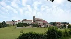 The church and surrounding buildings in La Chapelle-sur-Coise | |
Location of La Chapelle-sur-Coise 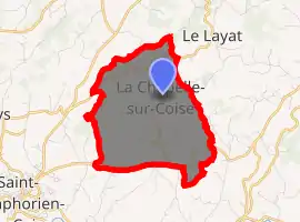
| |
 La Chapelle-sur-Coise  La Chapelle-sur-Coise | |
| Coordinates: 45°39′20″N 4°30′02″E | |
| Country | France |
| Region | Auvergne-Rhône-Alpes |
| Department | Rhône |
| Arrondissement | Lyon |
| Canton | Vaugneray |
| Intercommunality | CC des Monts du Lyonnais |
| Government | |
| • Mayor (2008–2014) | Raymond Pupier |
| Area 1 | 6.58 km2 (2.54 sq mi) |
| Population (2017-01-01)[1] | 573 |
| • Density | 87/km2 (230/sq mi) |
| Time zone | UTC+01:00 (CET) |
| • Summer (DST) | UTC+02:00 (CEST) |
| INSEE/Postal code | 69042 /69590 |
| Elevation | 599–784 m (1,965–2,572 ft) (avg. 700 m or 2,300 ft) |
| 1 French Land Register data, which excludes lakes, ponds, glaciers > 1 km2 (0.386 sq mi or 247 acres) and river estuaries. | |
The municipality is located about 390 km southeast of Paris, 33 km west of Lyon.
See also
References
- "Populations légales 2017". INSEE. Retrieved 6 January 2020.
- "Population in 2011" (in French). INSEE. Retrieved September 28, 2014.
| Wikimedia Commons has media related to La Chapelle-sur-Coise. |
| Authority control |
|---|
This article is issued from Wikipedia. The text is licensed under Creative Commons - Attribution - Sharealike. Additional terms may apply for the media files.