List of NSW TrainLink railway stations
NSW TrainLink is a train operator of passenger services outside the metropolitan area of Sydney in New South Wales. The network is divided into two tiers; intercity - a commuter-based rail network centred on the Greater Sydney area, and regional - long distance and interstate services. The network is served by a fleet of double-deck electric multiple units and single-deck diesel trains.
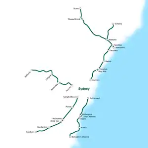
NSW TrainLink Intercity Map
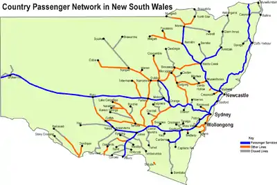
NSW TrainLink Interstate map (highlighted in blue)
For stations within the Sydney metropolitan area and shared with Sydney Trains, see List of Sydney Trains railway stations.
Stations
| Station | Code | Image | Line(s) | Distance from Central Station |
Date opened | Previous name(s) | |
|---|---|---|---|---|---|---|---|
| Aberdeen | ABD | (Scone Branch) | 300.730 | 20 October 1870 | |||
| Adamstown | ADT |  | 161.120 | 15 August 1887 | |||
| Albion Park |  | 103.340 | 9 November 1887 | Oak Flats (1887–1888) | |||
| Albury | ABX |  | 642.40 | 3 February 1881 | |||
| Armidale | ARM |  | 578 | 3 February 1883 | |||
| Austinmer | AUR |  | 68.590 | 1 September 1887 | |||
| Awaba | AWB |  | 137.310 | 15 August 1887 | |||
| Bargo | BZG |  | 102.870 | 13 July 1919 | West Bargo (1919–1921) | ||
| Bathurst | BHS |  | 239.900 | 4 April 1876 | |||
| Bell | BEL |  | 137.120 | 1 May 1875 | Mount Wilson (1875–1889) | ||
| Bellambi | BLM |  | 75.550 | 1889 | |||
| Bellata | BZT | 615 | 1897 | Woolbra (1897-1909) | |||
| Benalla | BEN |  | 742.6 | 18 August 1873 | |||
| Beresfield |  | 179.810 | 31 July 1925 | ||||
| Berry |  | 140.840 | 2 June 1893 | ||||
| Blackheath | BKE |  | 120.670 | 1 August 1862 | |||
| Blaxland | BXD |  | 71.480 | 11 July 1867 | Wascoes (1867–1879) | ||
| Blayney | BLA |  | 289.6 | 1847 | |||
| Boggabri | BGB | 515 | 1882 | ||||
| Bomaderry (Nowra) |  | 153.350 | 2 June 1893 | ||||
| Bombo |  | 140.840 | 9 November 1887 | North Kiama (1887–1889) Kiama (1889–1893) North Kiama (1893–1907) | |||
| Booragul | BGL |  | 146.390 | 24 October 1926 | |||
| Bowral | BWL |  | 136.340 | 2 December 1867 | |||
| Branxton | BNX |  | (Scone Branch) | 215.600 | 24 March 1862 | ||
| Brisbane Roma Street |  | 987.9 | 1876 | ||||
| Broadmeadow | BMD |  | 162.940 | 15 August 1887 | |||
| Broadmeadows | BMS |  | 921 | 1 February 1873 | |||
| Broken Hill | BHQ | 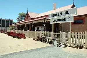 | 1,122.8 | 1919 | |||
| Bullaburra | BUB |  | 97.690 | 16 February 1925 | |||
| Bulli | BUI |  | 72.150 | 21 June 1887 | |||
| Bundanoon | BUN |  | 162.260 | 6 August 1868 | Jordans Crossing (1868–78) Jordans Siding (1878–1881) | ||
| Bungendore | BUX |  | 281.8 | ||||
| Burradoo | BUO |  | 138.840 | 1870, 1 March 1976 (reopened after closure in 1975) | |||
| Canberra | CBR |  | 329.610 | 21 April 1924 | |||
| Cardiff | CDF |  | 155.080 | 14 March 1889 (original site) 8 June 1902 (present site) | |||
| Casino | CSI | 803.9 | 1930 | ||||
| Coalcliff | CCF |  | 59.270 | 1 August 1920 | |||
| Cockle Creek | CCK |  | 150.630 | 15 August 1887 | |||
| Coffs Harbour | CFS |  | 607.810 | 30 August 1915 | |||
| Coledale | COL |  | 66.230 | 1 July 1902 (original site) 5 September 1906 (second site) 27 October 1912 (present site) | |||
| Condobolin | CBX |  | 546.300 | 1896 | |||
| Coniston |  | 84.100 | 1 April 1916 (original site) 1 November 1925 (reopen after closure on 29 April 1923) 20 May 1941 (present site) | Mount Drummond | |||
| Coolamon | CLO |  | 509.5 | 1881 | |||
| Cootamundra | CMD |  | 429.650 | 1877 | |||
| Corrimal | CIM |  | 76.990 | 21 June 1887 | |||
| Cowan | CWN |  | 48.810 | 1890 (originally) 6 October 1901 (with platform) | |||
| Cringila |  | (Port Kembla Branch) | 87.650 | 16 April 1926 | |||
| Culcairn | CUL | .jpg.webp) | 596 | 1880 | |||
| Dapto |  | 95.050 | 9 January 1887 | ||||
| Darnick | DNK | 879.2 | 7 November 1927 | ||||
| Dora Creek | DRK |  | 127.230 | 16 August 1889 | |||
| Douglas Park | DPK |  | 73.320 | 6 September 1869 (original site) 13 June 1892 (present site) | Douglass Park (1869–1891) | ||
| Dubbo | DBO | .jpg.webp) | 461.9 | 1881 | |||
| Dungog | DGG |  | (Dungog Branch) | 245.200 | 14 August 1911 | ||
| East Maitland | EAM |  | 189.097 | 27 July 1858 (original site) 2 May 1864 (second site) 25 March 1879 (present site) | Morpeth Junction (1858–1879) | ||
| Euabalong West | EUB | 617.8 | 1919 | ||||
| Eungai | ENG | 534 | |||||
| Exeter | EXT |  | 155.880 | 1878 | Badgery's Siding (1878–1890) | ||
| Fairy Meadow | FNW |  | 79.360 | 1887 | Cramsville (1887–1888) Para-Meadow (1888–1909) Balgownie (1909–1956) | ||
| Fassifern | FSN |  | 142.310 | 1888 (originally) 5 May 1891 (with platform) | |||
| Faulconbridge | FLB |  | 82.960 | 15 March 1877 | |||
| Gerringong |  | 128.560 | 2 June 1893 | ||||
| Geurie | GUI | 434.50 | 1885 | Ponto (1885-1889) | |||
| Glenbrook | GBR |  | 67.090 (present) | 11 July 1867 (original station) 11 May 1913 (present station) | Watertank (1867–1874) Wascoes Siding (1874–1878) Brookdale (1878–1879) | ||
| Gloucester | GCR |  | 309.30 | 5 February 1913 | |||
| Gosford | GOS |  | 80.910 | 15 August 1887 | |||
| Goulburn | GUL |  | 224.900 | 19 May 1869 | |||
| Grafton | GFN | 695.70 | 12 October 1915 | South Grafton (1915-1976) Grafton City (1976-2005) | |||
| Greta | GTA |  | (Scone Branch) | 210.800 | 6 September 1869 | Farthing (1869–1878) | |
| Griffith | GFF |  | 640.38 | 3 July 1916 | |||
| Gunnedah | GUH | 475.80 | 11 September 1879 | ||||
| Gunning | GNI |  | 278.60 | 9 November 1875 | |||
| Hamilton | HAM |  | 164.630 | 1872 | |||
| Harden | HRD |  | 385.40 | 12 March 1877 | Murrumburrah (1877-1878) North Murrumburrah (1878-1880) | ||
| Hawkesbury River | HKR |  | 57.400 | 1870 | Peats Ferry (1870–1888) Brooklyn (1888–1889) Hawkesbury River (1889–1890) Hawkesbury (1890–1906) | ||
| Hazelbrook | HZK |  | 93.470 | 1884 | |||
| Helensburgh | HSB |  | 46.380 | 1 January 1889 (original site) 30 May 1915 (present site) | |||
| Henty | HTY |  | 580.29 | 1880 (original station) 1904 (present station) | Doodle Cooma (1880-1891) | ||
| Hexham | HXM |  | 175.530 | 1 August 1871 | |||
| High Street | HGH |  | 191.410 | 27 May 1856 | |||
| Hilldale |  | (Dungog Branch) | 226.400 | 14 August 1911 | |||
| Ivanhoe | IVN |  | 816.40 | 19 August 1925 | |||
| Junee | JUE | .jpg.webp) | 485.67 | 6 July 1878 | Junee Junction (1881-1940) | ||
| Katoomba | KTO |  | 109.940 | 2 February 1874 | Crushers (1874–1877) | ||
| Kembla Grange |  | 91.590 | 1 January 1890 | ||||
| Kempsey | KPS | 503.65 | 3 December 1917 | ||||
| Kendall | KDL | 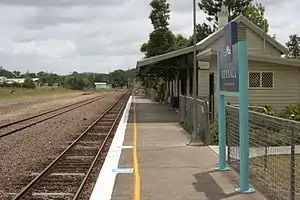 | 433.30 | 12 April 1915 | |||
| Kiama |  | 119.160 | 2 June 1893 | ||||
| Koolewong | KWG |  | 74.820 | 29 November 1920 | |||
| Kootingal | KNG |  | 472.10 | 9 January 1882 | Moonbi (1882-1914) | ||
| Kotara | KRZ |  | 158.920 | 12 November 1924 | |||
| Kyogle | KYO | 833.80 | 25 June 1910 | ||||
| Lapstone | LAP |  | 63.620 | 24 February 1964 | |||
| Lawson | LWN |  | 96.040 | 11 July 1867 | Blue Mountain (1867–1879) | ||
| Leeton | LEE | .jpg.webp) | 612.64 | 6 March 1922 | |||
| Leura | LEU |  | 107.590 | 6 December 1890 | |||
| Linden | LND |  | 86.810 | August 1874 (as tank stop) 26 October 1874 (with platform) | Linden Tank (1874) Henderson's Platform (1874–1879) | ||
| Lisarow | LRW |  | 87.730 | 31 October 1892 | Jenkins Siding (1892–1902) Wyoming (1902) | ||
| Lithgow | LTH |  | 155.780 | June 1877 (original site) 9 March 1855 (present site) | |||
| Lochinvar | LVR | (Scone Branch) | 202.600 | 2 July 1860 | |||
| Lysaghts |  | (Port Kembla Branch) | 86.270 | 30 May 1938 | |||
| Macksville | MXV | 552.4 | 1 July 1919 | ||||
| Maitland | MTL |  | 192.550 | 1880 | West Maitland (1880–1949) | ||
| Martins Creek | MCR |  | (Dungog Branch) | 218.500 | 14 August 1911 | ||
| Marulan | MRX |  | 192.910 | 6 August 1868 | |||
| Medlow Bath | MED |  | 115.800 | 21 January 1880 | Browns Siding Pulpit Hill (1880–1883) Medlow (1883–1903) | ||
| Melbourne Southern Cross | SSS | 17 January 1859 | Spencer Street (1859-2005) | ||||
| Menangle | MGE |  | 65.330 | 1 July 1863 | |||
| Menangle Park | MEK |  | 62.850 | 26 September 1937 | |||
| Menindee | MND | .jpg.webp) | 1006.60 | 15 July 1919 | |||
| Metford |  | 185.120 | 17 March 1995[1] | ||||
| Millthorpe |  | 302.60 | 1886 | ||||
| Mindaribba | MNB |  | (Dungog Branch) | 218.500 | 14 August 1911 | Dunmore (1911–1912) | |
| Minnamurra |  | 113.370 | 23 December 1891 (original site) 10 October 1943 (present site) | ||||
| Mittagong | MIT |  | 131.570 | 1 March 1867 | |||
| Moree | MRZ |  | 665.60 | 1 April 1897 (original site) 1904 (present site) | |||
| Morisset | MOI |  | 123.330 | 15 August 1888 | Morrisset (1888–1889) | ||
| Moss Vale | MSV |  | 145.710 | 2 December 1867 | Sutton Forest (1867–1877) | ||
| Mount Victoria | MVR |  | 126.720 | 6 September 1869 | |||
| Murrurundi | MDI |  | 352.30 | 4 April 1872 | |||
| Muswellbrook | MBK |  | (Scone Branch) | 288.800 | 19 May 1869 | Musclebrook (1869–1890) | |
| Nambucca Heads | NBH | 565.10 | 3 December 1923 | Nambucca Heads (original), Nambucca (1925-1964) | |||
| Narara | NRR |  | 84.600 | 15 August 1887 | |||
| Narrabri | NAA |  | 569.20 | 1 April 1897 | |||
| Narrandera | NRA |  | 583.48 | 28 February 1881 | |||
| Newcastle Interchange |  | 165.60 | 15 October 2017 | ||||
| Niagara Park | NIA |  | 86.190 | October 1902 | Tundula (1902) | ||
| North Wollongong | NHW |  | 81.320 | 19 July 1915 | |||
| Oak Flats |  | 105.130 | 1 January 1890 (originally) 9 March 1925 (with platform) 21 February 2003 (present site) | ||||
| Orange | OAG |  | 322.6 | 19 April 1877 | |||
| Otford | OTF |  | 52.639 | 3 October 1888 | |||
| Ourimbah | OUR |  | 90.610 | 15 August 1887 | |||
| Parkes | PKE |  | 445.5 | 18 December 1893 | |||
| Paterson | PTR |  | (Dungog Branch) | 213.200 | 14 August 1911 | ||
| Penrose | PRS |  | 171.400 | 1869 (as siding) 1 June 1871 (original site) 15 March 1916 (present site) | Cables Siding (1869–1871) | ||
| Picton | PIC |  | 85.250 | 1 July 1863 | |||
| Point Clare | PCL |  | 78.050 | 28 June 1891 | |||
| Port Kembla |  | (Port Kembla Branch) | 90.240 | 5 January 1920 | |||
| Port Kembla North |  | (Port Kembla Branch) | 88.770 | 9 March 1936 | |||
| Queanbeyan | QBN | .jpg.webp) | 321.46 | 8 September 1887 | |||
| Quirindi | UIR |  | 392.7 | 13 August 1877 | |||
| Rydal | RDL |  | 181.4 | 1 July 1870 | |||
| Sandgate | SDG |  | 170.510 | 1881 | |||
| Sawtell | SWT | 600.70 | 13 July 1925 | ||||
| Scarborough | SCB |  | 62.530 | 21 June 1887 (original site) 15 August 1915 (present site) | Clifton (1887–1888) South Clifton (1888–1903) Scarborough (1903–1915) Clifton (1915–1916) | ||
| Scone | NSO |  | (Scone Branch) | 314.660 | 17 April 1871 | ||
| Seymour | SEY |  | 20 November 1872 | ||||
| Shellharbour Junction |  | 110.660 | 22 November 2014 | Dunmore (Shellharbour) 800 metres away, 9 November 1887 | |||
| Singleton | SIX | (Scone Branch) | 238.900 | 7 May 1863 | |||
| Springwood | SPR |  | 79.670 | 11 July 1867 | |||
| Stanwell Park | SWP |  | 55.950 | 14 March 1890 (original site) 10 October 1920 (present site) | |||
| Stuart Town | SWN |  | 379.60 | 1 June 1880 | |||
| Tahmoor | TAH |  | 94.490[2] | 13 July 1919[2] | |||
| Tallong | TJG | 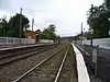 | 185.380[3] | 1869 (originally) 16 April 1878 (with platform)[3] | Barbers Creek Tank (1869–1905)[3] | ||
| Tamworth | TMW |  | 455.1 | 9 January 1882 | |||
| Tarago | TGO |  | 282.51 | 3 January 1884 | |||
| Tarana | TNJ |  | 198.3 | 22 April 1872 | |||
| Taree | TRO | .jpg.webp) | 378.60 | 5 February 1913 | |||
| Tarro | TRJ |  | 178.180[4] | 5 April 1857[4] | Hexham (1857–1871) Hexham Township (1871)[4] | ||
| Tascott | TSC |  | 76.910[5] | October 1905[5] | |||
| Telarah | TLR | 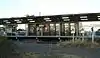 | (Dungog Branch) | 194.740[6] | 14 August 1911[6] | West Maitland Marshalling Yard (1911–1922)[6] | |
| Teralba | TBR |  | 147.570[7] | 15 August 1887[8] | |||
| The Rock | TRK |  | 550.29 | 1 September 1880 | Hanging Rock (1880-1882) Kingston (1882-1883) | ||
| Thirroul | TRL |  | 70.240[9] | 21 June 1887[9] | Robbinsville (1887–1891)[10] | ||
| Thornton | THO |  | 182.190[11] | 1 August 1871[11] | Woodford (1871–1877)[11] | ||
| Towradgi | TOW | 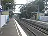 | 78.020[12] | 18 December 1948[12] | |||
| Tuggerah | TGG |  | 98.540[13] | 1890[13] | Tuggerah Lakes (1890–1891) Tuggerah (1891–?) Tuggerah Lakes (?-1911)[13] | ||
| Unanderra |  | 88.270[14] | 9 November 1887[14] | ||||
| Uralla | URL | 555.10 | 2 August 1882 | ||||
| Urunga | URA | 580.90 | 19 March 1923 | ||||
| Valley Heights | VHS |  | 77.410[15] | May 1875[15] | Eagers Platform (1875–1877) The Valley (1877–1880)[15] | ||
| Victoria Street | VST |  | 187.920[16] | 5 April 1857[16] | East Maitland (1857–1858) (closed) (1858–1877)[16] | ||
| Wagga Wagga | WGA | .jpg.webp) | 521.40 | 1 September 1879 | South Wagga Wagga (1879-1882) | ||
| Walcha Road | WLC |  | 517.9 | 2 August 1882 | |||
| Wallarobba | WLB |  | (Dungog Branch) | 231.700[17] | 14 August 1911[17] | ||
| Wangaratta | WAG |  | 28 October 1873 | ||||
| Warabrook | WBK |  | 168.690[18] | 23 October 1995[1] | |||
| Waratah | WTH |  | 165.970[19] | 9 March 1858[19] | |||
| Warnervale | WNV |  | 105.900[20] | 2 September 1907 (originally) 17 October 1910 (with platform)[20] | |||
| Warrimoo | WRM |  | 74.300[21] | 9 March 1918[21] | |||
| Wauchope | WAU | 455.00 | 12 April 1915 | ||||
| Wellington | WEL |  | 410.40 | 1 June 1880 | |||
| Wentworth Falls | WFS |  | 102.610[22] | 22 July 1867[22] | Weatherboard (1867–1879)[22] | ||
| Werris Creek | WCK | 410.7 | 1880 | ||||
| Wingello | WNE |  | 177.140[23] | 1 June 1871 (as siding) 1882 (as station)[23] | Unnamed (1871–1895)[23] | ||
| Wingham | WGM | 367.10 | 5 February 1913 | ||||
| Willow Tree | WTE |  | 375.70 | 13 August 1877 | Warrah (1877-1879) | ||
| Wirragulla | WGL |  | (Dungog Branch) | 238.000[24] | 14 August 1911[24] | ||
| Wollongong | WOL | 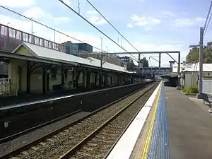 | 82.920[25] | 21 June 1887[25] | |||
| Wombarra | WMJ |  | 64.340[26] | 12 February 1917[26] | |||
| Wondabyne | WDB |  | 65.150[27] | 1 May 1889 (original site) April 1939 (present site)[27] | Mullet Creek Junction (1889–1890) Hawkesbury Cabin (1890–1891)[27] | ||
| Woodford | WFO |  | 90.370[28] | 11 July 1868[28] | Buss's Platform (1868–1871)[28] | ||
| Woonona | WOJ |  | 73.990[29] | 25 August 1919[29] | |||
| Woy Woy | WOY |  | 72.620[30] | 1 February 1889 (originally) 18 December 1891 (with platform)[30] | |||
| Wyee | WYE |  | 114.860[31] | 1 August 1892 (originally) February 1896 (with platform)[31] | |||
| Wyong | WYG | 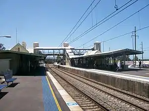 | 101.080[32] | 15 August 1887[32] | |||
| Yass Junction | YAS |  | 318.01 | 3 July 1876 | Yass (1876-1882) | ||
| Yerrinbool | YEB |  | 116.310[33] | 13 July 1919[33] | |||
| Zig Zag | ZIG |  | 150.940[34] | 15 April 1878 (originally) 1959 (after closure in 1910)[34] | |||
See also
- List of Sydney Trains railway stations
- Transportation in Australia
- Lists of railway stations
References
- Brian Langton MLA, "Questions and Answers – 491: Railway Station Openings" Archived 24 June 2014 at the Wayback Machine: New South Wales Legislative Assembly, Hansard, 16 April 1996, p. 1006. Retrieved 25 July 2007.
- Bozier, Rolfe, "New South Wales Railways: Tahmoor Railway Station. Retrieved 24 July 2007.
- Bozier, Rolfe, "New South Wales Railways: Tallong Railway Station. Retrieved 24 July 2007.
- Bozier, Rolfe, "New South Wales Railways: Tarro Railway Station. Retrieved 24 July 2007.
- Bozier, Rolfe, "New South Wales Railways: Tascott Railway Station. Retrieved 24 July 2007.
- Bozier, Rolfe, "New South Wales Railways: Telarah Railway Station. Retrieved 24 July 2007.
- Bozier, Rolfe, "New South Wales Railways: Teralba Railway Station. Retrieved 24 July 2007.
- City of Lake Macquarie, "Local History: History of Teralba". Retrieved 25 July 2014.
- Bozier, Rolfe, "New South Wales Railways: Thirroul Railway Station". Retrieved 24 July 2007.
- Forsyth, J.H. (ed.) (1988–93), Stations & Tracks; Vol. 1: "Main Suburban & Branches – Illawarra & Branches". State Rail Authority of New South Wales: Sydney, p. 145.
- Bozier, Rolfe, "New South Wales Railways: Thornton Railway Station. Retrieved 24 July 2007.
- Bozier, Rolfe, "New South Wales Railways: Towradgi Railway Station". Retrieved 24 July 2007.
- Bozier, Rolfe, "New South Wales Railways: Tuggerah Railway Station. Retrieved 24 July 2007.
- Bozier, Rolfe, "New South Wales Railways: Unanderra Railway Station. Retrieved 24 July 2007.
- Bozier, Rolfe, "New South Wales Railways: Valley Heights Railway Station. Retrieved 24 July 2007.
- Bozier, Rolfe, "New South Wales Railways: Victoria Street Railway Station. Retrieved 24 July 2007.
- Bozier, Rolfe, "New South Wales Railways: Wallarobba Railway Station. Retrieved 25 July 2007.
- Bozier, Rolfe, "New South Wales Railways: Warabrook Railway Station. Retrieved 25 July 2007.
- Bozier, Rolfe, "New South Wales Railways: Waratah Railway Station. Retrieved 25 July 2007.
- Bozier, Rolfe, "New South Wales Railways: Warnervale Railway Station. Retrieved 24 July 2007.
- Bozier, Rolfe, "New South Wales Railways: Warrimoo Railway Station. Retrieved 24 July 2007.
- Bozier, Rolfe, "New South Wales Railways: Wentworth Falls Railway Station. Retrieved 24 July 2007.
- Bozier, Rolfe, "New South Wales Railways: Wingello Railway Station. Retrieved 24 July 2007.
- Bozier, Rolfe, "New South Wales Railways: Wirragulla Railway Station. Retrieved 25 July 2007.
- Bozier, Rolfe, "New South Wales Railways: Wollongong Railway Station. Retrieved 25 July 2007.
- Bozier, Rolfe, "New South Wales Railways: Wombarra Railway Station. Retrieved 25 July 2007.
- Bozier, Rolfe, "New South Wales Railways: Wondabyne Railway Station. Retrieved 24 July 2007.
- Bozier, Rolfe, "New South Wales Railways: Woodford Railway Station. Retrieved 24 July 2007.
- Bozier, Rolfe, "New South Wales Railways: Woonona Railway Station. Retrieved 25 July 2007.
- Bozier, Rolfe, "New South Wales Railways: Woy Woy Railway Station. Retrieved 25 July 2007.
- Bozier, Rolfe, "New South Wales Railways: Wyee Railway Station. Retrieved 24 July 2007.
- Bozier, Rolfe, "New South Wales Railways: Wyong Railway Station. Retrieved 24 July 2007.
- Bozier, Rolfe, "New South Wales Railways: Yerrinbool Railway Station. Retrieved 24 July 2007.
- Bozier, Rolfe, "New South Wales Railways: Zig Zag Railway Station. Retrieved 25 July 2007.
- "Main Western Line". NSWrail.net. Retrieved 28 September 2011.
- "Main North Line". NSWrail.net. Retrieved 28 September 2011.
- "South Coast Line". NSWrail.net. Retrieved 28 September 2011.
External links
- Station details – Transport for NSW - Transport for NSW Info website showing details for all stations
| By state | 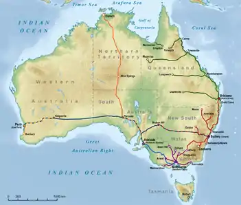 | |
|---|---|---|
| By capital | ||
| Stations |
| |
| Related articles | ||
This article is issued from Wikipedia. The text is licensed under Creative Commons - Attribution - Sharealike. Additional terms may apply for the media files.