List of National Natural Landmarks in Texas
From List of National Natural Landmarks, these are the National Natural Landmarks in Texas. There are 20 in total.
Texas National Natural Landmarks (clickable map)
| Name | Image | Date | Location | County | Ownership | Description | |
|---|---|---|---|---|---|---|---|
| 1 | Attwater Prairie Chicken Preserve | 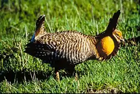 |
1968 | 29°40′08″N 96°16′00″W | Colorado | federal/US Fish & Wildlife Service | Contains the only significant segment of gulf coastal prairie. |
| 2 | Bayside Resaca Area | 1980 | 26°13′45″N 97°20′50″W | Cameron | federal/US Fish & Wildlife Service | Located in Laguna Atascosa National Wildlife Refuge, contains an excellent example of a resaca. | |
| 3 | Catfish Creek | 1983 | 31°54′27″N 95°54′09″W | Anderson | state/Texas Department of Parks and Wildlife | One of the few remaining undisturbed riparian habitats in the western Gulf Coastal Plain | |
| 4 | Caverns of Sonora |  |
1965 | 30°33′18″N 100°48′44″W | Sutton | private | Contains unusual formations, such as bladed helictites and coralloid growths |
| 5 | Devil's Sinkhole | 1972 | 30°00′57″N 100°12′31″W | Edwards | state/Texas Department of Parks and Wildlife | A deep, bell-shaped, collapsed limestone sink. | |
| 6 | Dinosaur Valley State Park |  |
1968 | 32°14′46″N 97°48′48″W | Somervell | state/Texas Department of Parks and Wildlife | The only known source of distinct and full-grown sauropod footprints. |
| 7 | Ezell's Cave | 1971 | Hays | private | Houses at least 36 species of cave fauna. | ||
| 8 | Enchanted Rock |  |
1971 | 30°29′46″N 98°49′12″W | Gillespie, Llano | state/Texas Department of Parks and Wildlife | A classic illustration of a batholith and of the exfoliation process. |
| 9 | Fort Worth Nature Center and Refuge | 1980 | 32°50′36″N 97°28′38″W | Tarrant | municipal/City of Fort Worth | Contains outstanding examples of the unique oak-hickory forest associations called cross timbers. | |
| 10 | Greenwood Canyon | 1975 | Montague | private | A rich source of early Cretaceous mammalian fossils. | ||
| 11 | High Plains Natural Area | 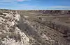 |
1980 | 34°55′10″N 102°06′40″W | Randall | federal/US Fish & Wildlife Service | One of the best developed, least disturbed natural shortgrass climax communities remaining in the Great Plains. Part of Buffalo Lake National Wildlife Refuge. |
| 12 | Little Blanco River Bluff | 1982 | Blanco | private | An unspoiled example of the limestone bluff communities of the Edwards Plateau. | ||
| 13 | Longhorn Cavern | 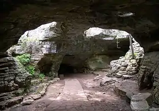 |
1971 | 30°41′04″N 98°21′03″W | Burnet | state/Texas Department of Parks and Wildlife | State park contains an outstanding example of cave features formed during the phreatic phase of development. |
| 14 | Lost Maples State Natural Area | 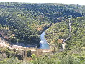 |
1980 | 29°48′28″N 99°34′15″W | Bandera, Real | state/Texas Department of Parks and Wildlife | An excellent illustration of Edwards Plateau flora and fauna. |
| 15 | Muleshoe National Wildlife Refuge |  |
1980 | 33°57′19″N 102°46′37″W | Bailey | federal/US Fish & Wildlife Service | Saline lake beds, and shortgrass grama grasslands characteristic of the high plains. |
| 16 | Odessa Meteor Crater |  |
1965 | 31°45′25″N 102°28′45″W | Ector | county | Contains two meteorite impact craters. The largest is 550 feet (170 m) in diameter. |
| 17 | Palo Duro Canyon State Park | 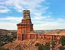 |
1976 | 34°59′05″N 101°42′07″W | Armstrong, Randall | state/Texas Department of Parks and Wildlife | Spectacular canyon that is an excellent example of a landform created by running water. |
| 18 | Santa Ana National Wildlife Refuge | 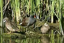 |
1966 | 26°05′07″N 98°08′04″W | Hidalgo | federal/US Fish & Wildlife Service | A living museum of the lowland forested area of the Lower Rio Grande Valley. |
| 19 | Natural Bridge Caverns | 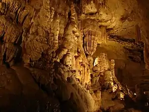 |
1971 | 29°41′32″N 98°20′34″W | Comal | private | A multilevel cavern system containing unusual speleothems and intricate helictites. |
| 20 | Cave Without a Name | 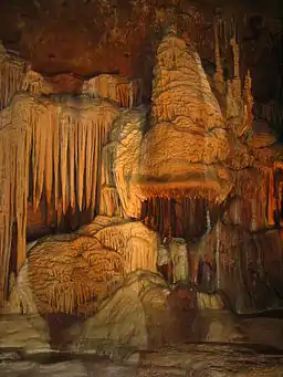 |
2009 | 29°52′45″N 98°38′31″W | Kendall | private | Contains rare and nationally outstanding examples of speleothems. |
This article is issued from Wikipedia. The text is licensed under Creative Commons - Attribution - Sharealike. Additional terms may apply for the media files.