List of bridges in the United States by height
This is a list of the highest bridges in the United States by height over land or water. Height in this list refers to the distance from the bridge deck to the lowest point on the land, or the water surface, directly below. A bridge's deck height is greater than its clearance below, which is measured from the bottom of the deck structure, with the difference being equal to the thickness of the deck structure at the point with the greatest clearance below. Official figures for a bridge's height are often provided only for the clearance below, so those figures may be used instead of actual deck height measurements. For bridges that span tidal water, the clearance below is measured at the average high water level.
.jpg.webp)
The minimum height for inclusion in this list is 130 ft (40 m), which may be either the deck height or the clearance below depending on available references. Note that the following types of bridges are not included in this list: demolished high bridges; historic high bridges such as those over reservoirs—regardless of current reservoir levels—that were filled after the bridge was complete, unless the dam has since been removed; and vertical-lift bridges, even those with raised span heights greater than this list's minimum height.
The clearance below required under bridges for the largest ships—container ships, ocean liners and cruise ships—is around 220 feet (67 m) so there are often bridges with approximately that height located in coastal cities with bays or inlets, such as New York City's Verrazano-Narrows Bridge and San Francisco's Golden Gate Bridge.[1]
List of bridges
Gallery
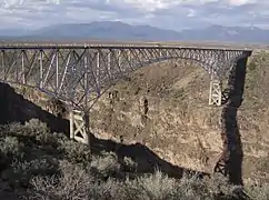
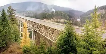
The ten highest bridges in the United States:
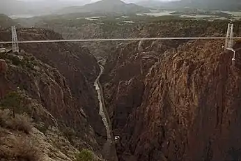 Royal Gorge Bridge—955'
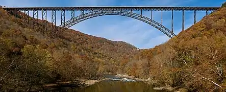
.jpg.webp) Foresthill Bridge—730'
Foresthill Bridge—730'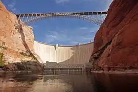
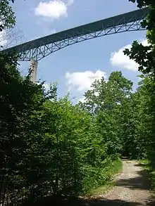
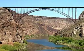 Perrine Bridge—486'
 Navajo Bridge—470'
See also
 Transport portal
 Engineering portal
 United States portal
- List of highest bridges
- List of longest bridges
- List of tallest bridges
Notes
- The americanbridge.net reference for Burro Creek Bridge provides a vertical clearance figure of 370 ft (113 m) which is 18 ft (5 m) lower than the deck heights for the two spans of this bridge as provided by highestbridges.com, the difference being due to the deck truss height.
References
- Sharp, John (August 10, 2014). "I-10 Bridge height to accommodate cruise ships, but what if they never come?". al.com. Alabama Media Group. Archived from the original on April 12, 2015. Retrieved October 28, 2016.
- Sakowski, Eric (December 5, 2010). "Burro Creek 1966 Bridge". highestbridges.com. Archived from the original on November 28, 2016. Retrieved December 20, 2016.
- Sakowski, Eric (December 5, 2010). "Burro Creek 2005 Bridge". highestbridges.com. Archived from the original on March 4, 2016. Retrieved December 20, 2016.
- "Burro Creek Bridge, Completion Date: March 01, 1966". americanbridge.net. n.d. Archived from the original on December 20, 2016. Retrieved December 20, 2016.
- Janberg, Nicolas (February 5, 2016). "Hoffstadt Creek Bridge". structurae.net. Archived from the original on October 25, 2016. Retrieved October 25, 2016.
- Sakowski, Eric (December 10, 2009). "Hoffstadt Creek Bridge". highestbridges.com. Archived from the original on October 25, 2016. Retrieved October 25, 2016.
- Sakowski, Eric (March 13, 2012). "United States Bridges 90 to 100 meters". highestbridges.com. Archived from the original on January 16, 2017. Retrieved April 7, 2017.
- http://www.ozona.com/pecos-river-highway-bridge
- Robinson Gibson, Allie (February 15, 2014). "460 Connector, CFX construction projects moving forward in SWVa". Bristol Herald-Courier. Bristol, VA. Retrieved June 15, 2017.
- "Corridor Q: Route 460 Connector - Phase I". Virginia Department of Transportation. February 24, 2016. Archived from the original on April 18, 2017. Retrieved June 15, 2017.
- "Evaluation of Condition-Responsive Work Zone Traffic Controls at the I-75 Clays Ferry Bridge". uknowledge.uky.edu. University of Kentucky. June 1998. p. 1. Archived from the original on February 25, 2018. Retrieved February 25, 2018.
- "Wrangell-St Elias National Park & Preserve: McCarthy Road Guide". nps.gov. National Park Service. n.d. Archived from the original on October 9, 2016. Retrieved October 26, 2016.
- "Iron Range celebrates tallest bridge in state". Twin Cities. 2017-09-17. Retrieved 2017-10-10.
- "Tallest bridge in Minnesota is dedicated. You can drive over it really soon". Twin Cities. 2017-09-17. Archived from the original on 2017-09-17. Retrieved 2017-10-10.
- Liebler, Kathy; Agnello, Joe (May 18, 1999). "New Mon/Fayette construction contract includes what will be the highest bridges on Pennsylvania Turnpike system". paturnpike.com. Pennsylvania Turnpike Commission. Archived from the original on October 26, 2016. Retrieved October 26, 2016.
- Cridlebaugh, Bruce (August 21, 2002). "Bridges & Tunnels of Allegheny County & Pittsburgh, PA: Pittsburgh West > East Street Bridge". pghbridges.org. Archived from the original on August 17, 2016. Retrieved October 26, 2016.
- Massachusetts Department of Transportation [@MassDOT] (29 May 2018). "District Highway in Lenox reports bridge design plans list approximately 166' from the road to the low water level in the river" (Tweet) – via Twitter.
- Lieberman, William (n.d.). "Pennsylvania Turnpike Commission; Retention of an Engineering or Construction Management Firm ... Reference No. – 5-087 [old name ref]" (PDF). paturnpike.com. Pennsylvania Turnpike Commission. Archived (PDF) from the original on October 27, 2016. Retrieved October 28, 2016.
- "The General Assembly of Pennsylvania; House Bill No. 1779; Session of 2009 [new name ref]". legis.state.pa.us. Pennsylvania General Assembly. June 24, 2009. Archived from the original on October 28, 2016. Retrieved October 28, 2016.
- "Benesch Transportation Projects [height ref: see 5th photo by scrolling down photo gallery, click on Clarks Summit Bridge photo, caption states height as 150 feet]". benesch.com. Alfred Benesch & Company. n.d. Archived from the original on October 27, 2016. Retrieved October 28, 2016.
- "Vietnam Veterans Memorial Bridge Design". modjeski.com. Modjeski and Masters. n.d. Archived from the original on November 11, 2019. Retrieved November 11, 2019.
- Turner, Jack (n.d.). "Rocky Mountain Exploration Part 3: Cumbres & Toltec Railroad". trainweb.org. TrainWeb LLC. Archived from the original on June 26, 2016. Retrieved October 26, 2016.
- "Cumbres & Toltec Scenic Railroad: Scenery Departing Chama, New Mexico". cumbrestoltec.com. Cumbres & Toltec Scenic Railroad. n.d. Archived from the original on March 29, 2016. Retrieved October 26, 2016.
- "The US 20 bridge over the Iowa River is a major transportation improvement and a distinctive feat of modern engineering". iowadot.gov. Iowa Department of Transportation. 2003. Archived from the original on May 23, 2009. Retrieved May 9, 2017.
- "Project overview: The bridge". iowadot.gov. Iowa Department of Transportation. 2003. Archived from the original on May 22, 2009. Retrieved May 9, 2017.
- Janberg, Nicolas (February 5, 2016). "Girard Point Bridge". structurae.net. Archived from the original on December 28, 2016. Retrieved February 5, 2016.
- "Henderson County Bridge 120 (High or Green River Bridge)". ncdot.gov. North Carolina Department of Transportation. July 11, 2018. Retrieved November 7, 2018.
- "High Bridge, Henderson County, North Carolina". bridgehunter.com. James Baughn. n.d. Retrieved November 7, 2018.
